Fun mix of south and east swells, best for the open beaches

South East Queensland and Northern New South Wales Surf Forecast by Ben Matson (issued Wednesday 4th May)
Best Days: Fun mix of east and south swells due from later Thurs throughFri/Sat.
Recap: Small pulsey E’ly swell across most coasts, plus a south swell that pushed up the Northern NSW coast yesterday, and is slowly fading today. Set waves have managed 2ft+ from the east, whilst the south swell reached 2-3ft at south facing beaches in Northern NSW. Ironically, I mentioned this south swell in Friday’s notes but in the rush to prepare this forecast on Monday, I completely forgot about it. Apologies! Wind wise, it’s been glorious with mainly light variable winds in most regions both days.
This week (May 5th - 6th)
Looks like more of the same for the next few days.
Although the current south swell is on the way out, the small east swell that’s been present all week is expected to continue into Thursday morning, before lifting slightly into the afternoon. This will precede a slightly stronger kick throughout Friday ahead of a peak on Saturday.
This east swell is being generated by a depresion that’s been developing south-east of Fiji over the last couple of days. It’s looking good on the synoptics, and with a slight westward push of the core fetch, we’ll see wave heights enhanced marginally over what would ordinarily be expected - which is a good thing as the large travel distance will erode eventual surf size at the coast.
The other good aspect for the rest of the week is a continuing weak pressure gradient will result in light variable winds both days across all regions. So there’s no need for an early surf as conditions will be favourable for much of the day.
As for surf size, we’re looking at inconsistent 2ft sets on Thursday morning lifting to 2-3ft throughout the afternoon across Northern NSW, though there will be a long break for the bigger waves. Surf size may be marginally smaller across SE Qld and the Mid North Coast (biggest in Far Northern NSW). Keep in mind that there'll be lully periods at times due to the distance source of the swell. And it'll be quite tidally influenced too.
On Friday, we can expect the morning to pan out similar to Thursday afternoon with inconsistent 2-3ft sets in Far Northern NSW (a little smaller elsewhere) but surf size should pulse throughout the day- probably after lunchtime - with a few bigger bombs at times. What will probably be more noticeable is the swell strength ratcheting up as the swell period increases by a second or two. However it will probably remain quite inconsistent.
It's also worth mentioning the chance for some more long period southerly swell in the water from Thursday afternoon into Friday, across Northern NSW. This will originate from the same extra-large swell that's pummelling the southern states today, exibiting swell periods in the 18 second range. These periods are likely to draw out a little more (19 seconds, maybe 20) as the energy pushes through the Tasman Sea however most of the swell was shadowed from our region due to Tasmania.
That being said, we certainly can't rule out the chance of reliable south swell magnets pulling in very inconsistent 3-4ft sets at times. Our model is estimating just 0.2m @ 18 seconds on Thursday afternoon (and moreso into Friday) but it frequently undercalls south swells that originate from behind Tasmania, so it'll be well worth keeping an eye on your favourite swell magnet throughout this time frame.
But, if you're at a beach that doesn't face due south, and especially if you're north of the border - you probably won't see much, if anything from this source. It will probably benefit just a handful of beaches at best, so don't work around it - try and maximise the east swell instead.
This weekend (May 7th - 8th)
The weekend forecast has improved, as an expected approaching front has been delayed by 24 hours, meaning the pre-frontal northerlies have been pushed back until Monday.
So, current expectations are that we’ll see mainly light variable winds both Saturday and Sunday.
As for surf, we’re looking at wave heights from the same east swell building into Saturday with the afternoon topping out at 3-4ft across most open beaches. It’ll ease slightly into Sunday but the morning should still have plenty of solid sets at times ahead of a gradual abating.
Friday's south swell - as flukey as it's expected to be - will ease slowly over the weekend. South swell magnets in Northern NSW should however continue to see 2-3ft sets at times, more so Saturday than Sunday. Don't expect much away from these locations.
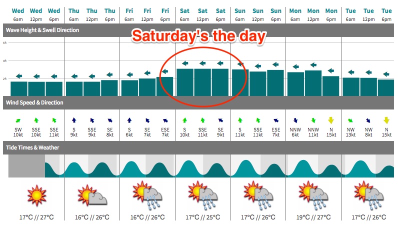
I’ll revise the model data on Thursday in case of any major variations (if so, will comment below) but at this stage it’s looking good both days - however certainly biggest on Saturday.
Next week (May 9th onwards)
The fetch responsible for the weekend’s swell is expected to remain active all the way through into Monday, though with a weakening trend. So we are looking at slowly easing easterly swell from Monday through until Wednesday, even Thursday morning may have some small residual lines. Despite the overall small size, that’s still a long lived swell event.
But, Monday now looks like it’ll be hampered by freshening northerlies. The Far Northern NSW and SE Qld regions may see a brief window of light winds in the morning but otherwise most regions will become wind affected throughout the day.
Winds should tend north-west into Tuesday as the front crosses the south-eastern corner of the country, ahead of over an overnight west-southwesterly change. Initially we’ll see no new swell during these days but regardless, Tuesday and Wednesday should have fun small waves across the open beaches as the east swell continues to abate, being brushed by nice offshores.
Gale-force south-westerly winds will also develop east of Bass Strait overnight Tuesday or early Wednesday (as the low tracks into the Tasman Sea) and this will generate a fresh south swell, probably arriving Thursday morning in Northern NSW. The acute southerly swell direction - in fact, more south-west if anything - will result in many beaches missing out, and only south swell magnets picking up any appreciable size. That being said, it looks like a larger version of what we saw yesterday so these exposed swell magnets could very well pick up occasional 4ft sets. Just keep your expectations low if you’re anywhere else, and also if you’re in SE Qld.
This period looks like it’ll see the end of the easterly swells, with several mid-latitude lows expected to track eastwards across our region. So the long term outlook suggests a series of southerly swells from next weekend and beyond.
See you Friday!
Comments
It's nothing like the Surf Coast, but this time of the year is sublime for the beachies. Looks like we've got plenty more to come!
Thanks Ben Saturday is a GO! I'm frothing out already
Unlikely high period sth swell for thurs arv... Duly noted Mr Matson
*taps finger to nose*
New long period S'ly swell (18 seconds) showing at Sydney buoy and starting to appear at Sydney beaches. Will be very interesting to see how much of this makes landfall at south swell magnets in Northern NSW.
this has been the best week of the year for rockfishing so I'll report back tonight. Been rockfishing three times a day and night all this week.
one thing about rockfishing exposed ledges....you become very sensitive to any and all swell directions, periods and sizes. It becomes a matter of life and death.
Energy has hit Coffs so shouldn't be too far off Steve.
Small but super clean and lined up nicely across the Superbank this arvo. Would be fun on a fish!
Super fun beachies again this morning, mix of east and south swells (S swell was inconsistent but most dominant, though not showing on Tweed buoy!), sets in the 3ft range at times. Just had lunch across the road and the swell seems a little more consistent out of the east, this is hopefully the expected afternoon pulse ahead of the peak tomorrow.
Fucking where, Ben? The sand, banks, options around here, ARGHHH! ... Might just give up and go fishing. Bloody deep long shore gutters!
Burleigh starting to show some form too.
And Moffs is looking mighty fine now too with this east swell.