Lots of swell from the east and south, for the next week or more

South East Queensland and Northern New South Wales Surf Forecast by Ben Matson (issued Friday 18th March)
Best Days: Small fun beachies early Sat before a S'ly change kicks in. Building S'ly swell Sun, best suited to semi-exposed points in Northern NSW (small waves north of the border). Wide range of E and SE swells for much of next week, potentially sizeable though this is more likely in the south.
Recap: Plenty of fun waves over the last few days, easing slightly from 2-3ft+ at most open beaches early Thursday to 2-3ft yesterday afternoon, holding in this size range through today though with a little less consistency. Yesterday maintained early SW tending SE winds however this morning we saw light variable winds and then afternoon NE sea breezes.
This weekend (Mar 19th - 20th)
No changes to the weekend outlook. A southerly change will move up the NSW coast overnight, reaching the Mid North Coast before dawn on Saturday, before then crossing the border just before lunchtime.
Ahead of the change we’ll see light W/NW winds but in its wake gusty S/SE winds will develop, so you’ll want to make the most of the early session for the best conditions (note: there may not be a window of opportunity south of Coffs).
As for swell, we’re looking at a small, inconsistent and somewhat weak residual E’ly swell, with occasional pulses from distant fetches embedded in what’s been a mainly moderate trade flow in our far swell window throughout the middle to latter part of this week. Wave heights should reach 2ft+ at most open beaches from this source for much of the weekend, with smaller waves running down the points.
A ridge will anchor itself in place behind the change, which will generate some short range windswell for most regions (nothing to worry about in general), however we’ll also see some southerly groundswell form the parent low (developing east of Tasmania this evening). The models have strengthened this system considerably since Wednesday’s notes, so the forecasts correspondingly been upgraded.
The swell direction from this source will be very southerly, so there’ll be a huge variation in size across the region - SE Qld won’t see much, if any energy from this swell, whilst south facing beaches in Northern NSW will see wave heights increasing all day, reaching 4ft to maybe 6ft at some of the more reliable swell magnets across the coast by the late afternoon (smaller earlier). However, this will be restricted to just a small number of locations, and they’ll be quite wind affected under the lingering southerly breeze (15-20kts). Winds may be lighter SW for a brief period early - but surf size will be smaller at this time.
Surf spots in Northern NSW not directly open to the south will see much smaller wave heights, so I’m not confident that - despite winds being favourable - the semi-exposed points will have any notable size. They will probably be your best bet though, with mix of refracted southerly swell, short range S/SE windswell and mid-range E’ly trade swell. - perhaps 3ft+ on the sets here, even smaller at protected spots with the E’ly swell more dominant.
Across SE Qld, Sunday won’t see much southerly swell away from the handful of exposed south swell magnets (which will be wind affected anyway) so aim for small runners across the outer points. Winds will be moderate to fresh S/SE but a few locations such as the southern Gold Coast may see a small window of early light SW winds. Certainly not worth too much attention, but there’ll be surf around the traps.
Next week (Mar 21st onwards)
Sunday’s building southerly swell will ease steadily through Monday though south facing beaches in Northern NSW should still ave plenty of size on offer early morning, anywhere from 3-5ft across the Mid North Coast and 4-6ft across the Northern Rivers (a little more size here as the swell will be decaying, so it’ll begin to ease earlier at southern locations). Expect smaller surf at semi-exposed points, and other protected locations.
SE Qld will see a smaller mix of peaky swells from the S, S/SE and E, perhaps around the 2ft mark at most open beaches and outer points, up to 3ft+ at south swell magnets ahead of an easing trend.
A new ridge is expected to build across the region some time on Monday, renewing gusty SE winds at most locations however there’s a reasonable chance for a slack period between ridges, so Monday morning may see a few hours of early light SW winds. But keep an eye out as it’s likely that the cross-onshores will redevelop earlier rather than later, relegating the only rideable waves to sheltered points throughout the day.
The remained of next week looks great for surf, thanks to a broad, slow moving high pressure system east of New Zealand that’s expected to slowly intensify through the weekend. A broad belt of trade winds across its northern flank will slowly enlarge and strengthen, and will also be fed by an approaching monsoon trough from the NW containing a couple of tropical systems (and maybe a tropical cyclone).
This is expected to supercharge the head of the trade flow, focusing it into an easterly dip just NW of New Zealand around Monday, and possibly forming a Tasman Low off New Zealand’s West Coast on Tuesday.
This setup presents several swell sources for the rest of the week. As a minimum, we’ll see building trade swell from the broad fetch above the high, which should be worth an inconsistent but long lived 3-4ft building from Tuesday through Wednesday and Thursday, maybe even Friday at a pinch. This swell should favour most coasts (though may be a little slow to build on Tuesday morning).
At the same time, as the E’ly dip develops we’ll see a new ridge strengthen through the southern Tasman Sea that’ll generate some mod-range SE swell for Northern NSW - nothing over the top, but a good 3ft for open beaches around Tuesday and Wednesday.
And then we have a stronger potential swell from the east from the E’ly dip itself.
Now, it’s worth pointing out that the models have been moving to and fro on the strength, timing and position of this fetch over the last few model runs so we’ll need to evaluate things again in more detail on Monday. In particular, the latest guidance is now focusing the core fetch towards Southern NSW and Tasmania, meaning we’d see a smaller spread of swell north of about Sydney.
So right now, whilst I’m reasonably confident on the broader swell prospects for the east, this E’ly dip-cum-Tasman-low is a far riskier proposition. As I’m sure Queensland surfers don’t really care if Southern NSW picks up a strong swell from this system - the only thing that matters is what eventuates in your own hood.
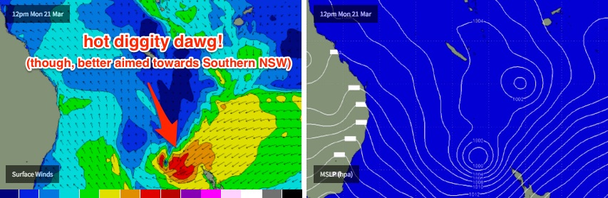
Gut feel suggests Southern NSW will end up seeing the best waves from this source (arriving overnight Wednesday, showing most prominently Thursday), with any longer period E’ly swell from the Dip likely to be biggest across the Mid North Coast (say, 4-5ft+ sets?), with size trending smaller with increasing northerly latitude. SE Qld may in fact see smaller swell from this source, than the pre-existing trade swell.
The other risk is that as the Dip/Low travels south through the eastern Tasman Sea, it may also drag the broad belt of trade winds (N and NE of New Zealand) south with it - and into the swell shadow of New Zealand. I don’t think this will pan out quite this far, but it’s worth considering - if it did happen I’d have to pull back on the estimates above (mainly the duration of the trade swell, that is).
Anyway, the positive news is that there is a bunch of decent swell sources in the forecast so there are plenty of waves on offer for at least the next week or more. Hope you score some of it!
Comments
The machine just won't stop!
No. You underestimated the strength of that S/SE swell here. Was still 3-4ft at S facing beaches here this afternoon.
Can anyone remember a better run of swell ? Not massive but fairly consistent on the mid north coast since Xmas day ! Couple of smaller days but nearly always something surf-able ! Global warming may well lead to the human apocalypse but we may well die happy in a surfeit of swell before!
I cant. Best run of waves I can remember, im tring to make the most of it where ever i can. Water still 26c on the sunny coast too
Après moi le déluge!
As evidenced by the total lack of response to this thread: http://www.swellnet.com/forums/wax/314352
Fun clean beachbreaks AND southwest winds. Hello and welcome Autumn!
Does anyone know if local seq winds will be light early Tuesday, we'd?
Ben, on the Sunshine Coast Surf Report page how is the data generated for the Wind History? (ie the forecast winds?)
too early to start getting excited over the WAMS for easter?
"Familiarity breeds contempt"...... May I suggest you all sink your teeth into the next week of swell...... Nothing lasts forever... And I bet many are taking this run for granted..... Easter onwards looks flat and shitty.... Could the longest run of swell be followed by the longest flat spell? Time will tell..
that S swell was strong today.
Could be wrong, and wouldn't be the first time, but I think that super long distance ese swell is in the water up on the sunny coast.. the swell i was talking about originating from east of N.I. NZ.
Quote Sheepio "east of N.I. NZ."
NI = Pig Island Sheepio, get it right next time please;)
Well I've lost Richie's keys and a Julius marlow in the pitch today Bill. The biggest crack I'd be aiming for would be the lack of groundswell on the Bundy buoy. The pitch is crumbly to the South with S'ly wind and groundswell :p
Geez, Tony.... Open ya fuckn eyes... This wasn't some scg wind swell on saturday afternoon through to sunday pulsing at 11 to 13 seconds.... Even the supporters up in Bundaberg could see that through the wind chop.... Now find Richies fuckn keys or we get no iced vo vo's with our tea :p
Jokes aside... Some odd period readings.... Had a look at a few selected cams.... Definite long period lines among the crud.
Haha yes, all I'm really saying is that I scoped the Eden buoy last night and it was a 15sec close range groundswell heading N. That's under the mask of the frontal windswell...
Doesn't explain long 2 to 3 foot lines at marcoola or coolum from ese this morning... Similar 11 second pulses at Mackay since sat arvo.
Doesnt really matter.... Wind fucked it anyway.
Canary yellow indeed
Umpire Les Behan: "wide"
What time does it take a swell to travel from out south of Samoa to our shores?
3 days min ?