Small peaky beachies for the most part; better E'ly groundswell mid-next week

South East Queensland and Northern New South Wales Surf Forecast by Ben Matson (issued Wednesday 16th March)
Best Days: Plenty of small beachies most days, wind affected Sat PM and Sun though. Fun E'ly swell early next week; stronger E'ly groundswell Wed onwards.
Recap: Lots of great waves over the last few days. Peaky E’ly trade swell persisted into Tuesday morning with solid 3ft+ sets for the early session across SE Qld and Far Northern NSW, but size eased throughout the day. As expected, a minor pulse of trade swell increased the surf to 3ft+ across these regions again today, though wave heights have been a little smaller across the Mid North Coast. Winds have been mainly moderate to fresh from the SW thru’ SE in northern locations, with lighter winds in the south.
This week (Mar 17th - 18th)
Our primary, near source of trade swell began to weaken yesterday so from here we’re looking at a slow easing trend into Thursday. However the trades are still quite active out towards Fijian longitudes, so we won’t lose too much size - the surf should continue to provide fun peaky options at most open beaches all the way into the weekend (and beyond, but more on that below).
In addition to this, the Northern NSW coast will receive a shot of S/SE swell on Thursday from a near-stationary fetch off the Southern NSW coast today.
As for size, early Thursday morning should still offer occasional 2-3ft+ sets across exposed SE Qld and Far Northern NSW beaches early morning (smaller running down the points), and the expected S/SE swell for Northern NSW should provide a similar size range at south facing beaches. Wave heights should ease a little during the day.
Winds are looking pretty good at most locations, with light SW breezes early tending S’ly then S/SE mid-late morning onwards. But no major strength is expected into the afternoon.
On Friday, both the E’ly and S/SE swells will weaken slightly, offering somewhere between 2ft and very occasionally 3ft at exposed beaches - down a little in size from Thursday, but probably more prominently in the strength department. Expect smaller waves at sheltered locations and points.
Fortunately, local conditions are looking very good with early light winds tending NE into the afternoon. The Mid North Coast will probably experience fresher afternoon breezes, but either way the morning will offer the best conditions at most locations.
This weekend (Mar 19th - 20th)
We’ve still got a tricky outlook ahead, but the expectations for a southerly change on Saturday are still on track.
In fact they’ve been pulled forward a little - it looks like the Mid North Coast will see the change through around dawn, with southerly winds reaching the border around lunchtime. Prior to its arrival, light northerly winds are possible. Moderate to fresh SW tending S/SE winds are then expected through Sunday as the ridge maintains its coastal presence.
As for surf, the next round of E’ly swell has also been delayed a little. A strengthening belt of trades south of Fiji on Thursday now looks like it’ll develop a small embedded tropical system for a day or two, but the main pulse from this probably won’t arrive until very late Sunday, or more likely Monday morning.
However, the head of the tradebelt will be active prior to this system reaching peak intensity, and closer to the mainland too. This should keep most open beaches humming with peaky 2ft+ surf all weekend. It’ll be a little slow, inconsistent and tidally dependent but there’ll certainly be waves about the traps. Don’t expect a great deal of energy across the points though, both days will definitely be best suited to wide open beach breaks.
Also in the water over the will be some remnant S/SE swell from the Thursday pulse (easing through Saturday) plus some building short range S/SE windswell on Sunday in the lee of the southerly change. Exposed south facing beaches will pick up the bulk of this low quality windswell, and they'll be bumpy under the southerly breeze too. So don't get too excited about it.
Putting this all together, and it looks like both mornings will offer the best waves, across open beaches. Early Saturday should see clean peaky beaches in the north ahead of the S’ly change (there’s a risk this won’t occur across the Mid North Coast), and Sunday morning should offer a period of early SW winds before the synoptic breeze kicks into gear again throughout the day, creating bumpy conditions after lunch.
Next week (Mar 21st onwards)
There is still plenty of swell on tap for next week.
As mentioned above, we’ve got a small pulse of E’ly swell due on Monday, with occasional sets in the 2-3ft range at most open beaches. I’m not overly confident for anything amazing but there’ll certainly be halfway decent waves at open stretches if the ridge generating Sunday’s winds eases enough to allow for a period of light variable winds in the morning.
Gusty trades are expected to remain anchored in our mid-to-far swell window over the weekend (S/SE of Fiji), whilst a broad tropical depression to the north pushes south, tightening the squeeze between the two and strengthening the fetch. By the end of the weekend it looks like we’ll have quite a healthy system north and northeast of New Zealand, that should generate a two or three day run of decent E’ly groundswell, somewhere between 3ft and maybe 5ft at exposed beaches.
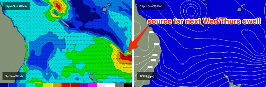
This swell is currently pegged to arrive Wednesday, with a peak in size likely around Thursday (I’ll fine tune the specifics in Friday’s notes). However early indications suggest that while the early part of this swell will be favourably aligned for most coasts, the southward track of the core fetch will push it slowly inside the swell shadow of New Zealand. This will initially reduce the size potential for more southern locations, so at this stage I’d be hedging my bets on an extended period of quality surf across the Gold and Sunshine Coasts.
The models are also suggesting a tropical cyclone will form near New Caledonia over the weekend though it probably won’t be in a favourable position for quite some time. Gut feel points towards a scenario whereby the cyclone becomes absorbed into the ridge early-mid next week, enhancing the surface wind field considerably and generating a second pulse of easterly groundswell for the end of next week or the weekend. But this is still quite some time away.
Elsewhere, the Tasman Sea will remain quite unstable throughout the entire forecast period thanks to a broad trough stretching its entire length. Whilst there are no major systems of interest in the current progs, many of the ingredentients are certainly lining up for a potential development sometime next week.
Let’s see how things are looking on Friday. ‘Till then, enjoy your beachies!
Comments
I love autumn, a cool wind, clean waves~~~
reminisce ~~~ 86' was a favourite;~~~~ 3mths of swell for NE NSW~~~~everyone had good waves~~~~(many boys in barrels....Thank you Mr C for that video)...
R.I.P. George Martin; music producer & fifth beatle.
A solid pulse at coffs this evening, well into the 4 foot range.
Great way to wash off a tough day in the office.
Fingers crossed we get an Easter swell thats pumping!!!
Super fun peaky beachies this morning, mainly 2-3ft but one rogue set came through when I was in the water that was just north of 3ft. Airbrushed by a light SW breeze. Love autumn!
Pretty sure I said a few weeks ago Autumn is the best time of year for "airbrushed" conditions in the mornings. Bring on April/May I say!!!
We haven't had a single airbrushed day here since autumn started Don. pretty relentless onshore flow or morning sickness gurgle under an anaemic sou-wester.
Well Ben said yesterday was one of them and I noticed it looked pretty clean and Autumn-ish on the comp on Wed morning also.
But I take your point Steve and this is why I also said "Bring on April/May".
Something brewing on the Byron buoy graph
What do you see Mitch? Doesn't look like much to me.
H and periods slowly building for more than an up and down spike today...
Don, part of that cape low may spin off to the se, and interact south if Fiji.... So that monsoon both you and I have been watching very well could still play a part..
Yeah def looks like Yvette forms, problem is she's very compact and no support ridge and moves away/across the great circle paths. Could be a secondary system "pop up" along the monsoon trough however very late in the piece.
Hmm, not at what I'm looking at... Crosses New Cal and snuggles up to that fetch?
Tasman sea looks far more interesting to me, first hints of a classic autumn pattern.
For something TOTALLY different, FR, I disagree lol
I find this waaaaay more interesting out east than anything I see southwards.... Time will tell
Rubbish up here. Southern Goldy the go again methinks.
Quick note for surf reporter Mark Pridmore.
Excellent reporting, no banks up here; everyone should head to snapper....I hear it's all time!
Ben, light sw winds still forecast for first thing tmrw morn Sunshine Coast?
Yep should be early SW winds. Sou'easters are up a little more than I'd like right now, but the synoptic flow should ease back overnight. Expect slightly smaller, weaker surf though.
Surfed late yesty and the swell had dropped a touch (still 2-3ft, just no 'plus' sets as was showing in the morning). SE winds were into it but there were still a few OK waves.
'Twas much cleaner this morning, but noticeably weaker for the most part with sets around 2ft. Every so often a bigger 2-3ft set would push through, with more strength - seems these very inconsistent sets were generated by that E'ly fetch north of NZ early/mid week. But the way the swell was behaving across the beaches, there was a lot of weaker short range stuff in the mix.
Still plenty of fun though. Sea breezes will be up soon though, there was no wind through the morning and it was heating up nice and early.
I noticed few solid sets from the south at an east facing ballina beach last night, Ben.
Would that be right?
Yep.. as per the notes above: "the Northern NSW coast will receive a shot of S/SE swell on Thursday from a near-stationary fetch off the Southern NSW coast today."
that swell was pretty solid where I went. Ballina magnet. lot of water moving around.
I reckon that rise in Hsig and Hmax early Thursday on Byron graph might have been SE swell from Tasman, just took a bit for the direction (graph) to change...