Easterly swells as far as the eye can see; aim for early mornings

South East Queensland and Northern New South Wales Surf Forecast by Ben Matson (issued Wednesday 17th February)
Best Days: Most days will have great waves but Thurs/Fri and maybe even Sat (mainly in the south) will probaly become wind affected from the NE so aim for an early paddle. Back to S/SE breezes from Sunday, favouring the SE Qld outer points though with smaller swells. Potentilaly a large, long period E'ly swell from Tuesday onwards with great surf beyond this, as far as my eyes can see.
Recap: Impossible to complain over the last two days. The expected renewal of E’ly swell came in bang on size expectations - generally 3-5ft across most coasts; a little lully but very well defined, and producing some incredible footage from the usual suspects. The only feature of major interest from a hindcasting perspective was that the swell kicked in early/mid morning on Tuesday, rather than in the afternoon as I had suggested in these notes. But I was never very confident with the timing on this particular pulse anyway, for a bunch of reasons that I’ve gone into detail about before (so I won’t bore you with the specifics a second time 'round). Tuesday’s winds were light offshore in most areas early, and fresh NE sea breezes created problems into the afternoon. Today’s southerly change was weaker than expected, which had two flow on effects - (1) the morning offshore persisted for a little longer, and (2) due to the weaker gradient flow, we’ve seen winds swing more to the SE, even E’ly in some regions.
This week (Feb 18th - 19th)
In short, no major changes for the rest of the week, which contains an an interesting dual swell situation for Northern NSW.
Essentially, our current easterly swell will continue to do what it’s done for the last few days, though we’ll probably see the consistency start to drop, thanks to the swell source retreating eastward earlier in the week as TC Winston tracked towards Samoa.
So, expect longer breaks between the bigger sets - across SE Qld, you’ll probably be doing most of your surfing in the sub-3ft range both Thursday and Friday, with fifteen minutes or more between bigger sets that'll be somewhere near 4ft+ (with smaller surf as you work your way down the points). These bigger sets may also have a smaller wave count than what we’ve been seeing over the last few days - again, attributable to the long travel distance. For crowd control reasons, this combo will favour the beachies over the points.
Aim for a morning surf with early light variable winds, as NE sea breezes will freshen from mid-late morning onwards. Similarly inconsistent swells will persist on Friday, and the nor’easter will become a little fresher, a little earlier - so you will have to aim for a morning paddle once again.
Thursday's size range will also hold steady from the east across Northern NSW, but we have a strong secondary southerly swell pushing up the coast that will provide solid waves to south swell magnets south of Byron. This swell was generated by a deep Southern Ocean low that stalled in our swell window yesterday (near Tasmania) and has today pushed up into the southern Tasman Sea.
Model guidance has every so slightly pulled back the strength of this low, so I have correspondingly wound back the size projections a smidge. We should see a peak through late Thursday afternoon (Mid North Coast) with Friday morning seeing the peak across the Far North Coast. South facing beaches should see solid 4-5ft sets from this source, though the swell direction will create much smaller waves at beaches not directly open to the south (though, this won’t be a problem as much as it usually is, because of the solid pre-existing E’ly swell).
Some south swell magnets north of the border may pick up occasional 3ft sets from the south on Friday but the easterly swell will probably remain dominant.
It’s also certainly not out of the question to expect occasional bigger rogue waves from time to time at exposed beaches in Northern NSW, if we see the easterly and southerly swell trains combining in the surf zone. But this will be the exception rather than the rule at most locations. Expect the southerly swell to ease slowly through Friday, more quickly in the south than in the north.
Light winds and NE sea breeze are expected on Thursday, whilst freshening NE winds will likely create problems through Friday at most locations so you will have to aim for an early surf will conditions are calm and/or variable.
This weekend (Feb 20th - 21st)
We’ve got a great weekend of waves ahead.
A weak trough near New Caledonia on Friday is expected to move slowly westward, and a narrow high pressure system in the central/northern Tasman Sea is expected to drive a ridge across the Queensland coast - but probably not until Saturday afternoon (and more so into Sunday).
So, Saturday is at risk of fresh NE sea breezes developing - mainly in Northern NSW, especially south of about Byron Bay. Elsewhere we may see more of an early light variable wind tend E/SE throughout the afternoon, ahead of freshening S/SE thru’ SE winds on Sunday (following a brief window of early SW winds). I’ll update the wind particulars in more detail on Friday.
As for surf, both of Friday’s sources - (south and east) will slowly ease. A minor intensification of the Tasman Low near New Zealand’ South Island tomorrow now looks like it won’t be quite enough to generate any meaningful increase, so expect easing size from Saturday morning (early 3ft sets at south facing beaches) down to 1-2ft by Sunday.
The E’ly swell should still manage peaky 3ft+ surf across SE Qld and Northern NSW beaches on Saturday, but it’ll ease slowly throughout the day and into Sunday, where we're looking at very inconsistent 2-3ft surf at exposed beaches.
However, the building ridge across the Qld coast will extend quite a broad distance into the Coral Sea and this should rebuild short range SE swell across SE Qld and Far Northern NSW into Sunday. Surf size will be biggest at open beaches on the Sunshine Coast (3ft+ by the afternoon, smaller earlier), but these spots will be wind affected. Surf size will become smaller with increasing southerly latitude - we’re probably looking at 2-3ft+ across the Gold Coast, with smaller surf at the outer points, and then smaller waves as you travel south of the border.
Next week (Feb 22nd onwards)
The latest model runs are holding true for TC Winston with a possible sharp southerly then westerly recurve later this week, aimed back into our region - and at Cat 4 strength, plus the added bonus of a strong supporting ridge to the south-east. The synoptics look insane.
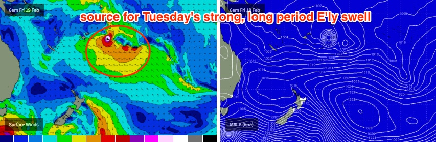
Whilst this system is still a considerable distance from the mainland, its impressive longevity and desirable forward track through our swell window (notwithstanding the potential interference by some South Pacific islands, depending on the precise location of the core fetch) augers well for an increase in strong, long period E’ly groundswell early Tuesday, persisting through Wednesday and then easing slowly from Thursday.
At this stage it’s completely reasonable to expect solid surf reaching 5-6ft+ across exposed coasts, though this size range will require a few things to come together - if the models change then we could see a downgrade. But confidence is certainly increasing on this prospects of this happening.
Otherwise, the Coral Sea ridge will maintain small but useful trade swell for SE Qld and Far Northern NSW on Monday and Tuesday.
TC Winston is currently expected to main strength in the South Pacific until the end of the model run, so in reality we could be looking at some kind of easterly swell persisting through until the end of next weekend. If that eventuates, then TC Winston could be the first weather system in a very long time to supply almost two weeks of continual swell. I’ll have to check on the specifics but could this be a record swell duration for a Tropical Cyclone? I’m not sure, but either way it’ll be worth celebrating.
Comments
Yeeha!
What's the snapped-board count right now?
c
2... in 3 days :(
Yew!
Waves, waves, waves, waves,waves.
No snapped boards here, fingers x.
This morning was the most powerful of the last 3 days IMO. Ballina shire.
No snapped boards but my back feels pretty fucking torqued.
Victor made me a believer on these long range E's. Here's hoping Winston provides more of the same.
Does anyone remember the "23 day swell" lol? Shit what year in the 70s was that?? I know it pumped the week before the 77 stubbies, then during the stubbies, then the week after.... But I cant remember the year of the 23 day swell... Interesting to see if it was El Nino, la nina, or neutral...
1974 rings a bell..
Do you think northern goldy beaches will be surfable early tomorrow morning? Or closing out still?
I really don't like the look of that wind forecast for the next 2 days
That damned system just keeps on giving, for the northern hordes at least.
I'm with you Kaiser, gutted about the winds for Friday I have that day off. Ben, what sort of wind do you imagine the sunny coast might have on Tuesday morning or is it too far away to even estimate at this stage? I'm might get up extremely early on Friday and hope for the best on the tweed
Too early to be totally confident but right now I'd hazard a guess for overnight SSE tending light to moderate SSW but with a slight wobble through the lineup. Clean on the points though. Tending moderate SSE during the day.
"As far as the eye can see"? Haha this is where you need my help Ben. I'm an expert in super long range forecasts, and I've just had a look at the charts and crunched some numbers for you. Yep it's going to keep on pumping for a couple more weeks at least. On March 10 it will then go more or less flat for about 2 weeks, from there it will fire pretty much non stop for most of Autumn. You are more than welcome to use this information, it's very reliable. Cheers
Well, I got it wrong about the consistency. Looks the same, if anything a little more consistent than yesterday. Solid sets here too, easy 4-5ft.
Coffs was pretty solid this morn, well into 5+ territory.
or maybe that is just fear talking.
Yep that correlates well with what my mate saw this morning down Ben's way. Sets well into the 5ft+/6ft range he said. But others on here might call that 3-5ft!!!
Got ready and headed out through a busy period of back-to-back 4-5ft sets. A bunch of us punched across the bar at the same time, and old mate on a longboard snapped his board in two pieces simply duckdiving a wave! There was a LOT of water moving around - it was the strongest day of swell in recent weeks, as far as I have seen anyway.
But after that early activity, it settled back to a more lully 3-4ft range in the sets, with bigger waves very infrequently. Ended up being quite a bit of northerly wobble through the lineup.
There were all kinds of swells in the water in the water too - a mid range and a long range E'ly swell, some of them displaying a distinct northerly component but it also appeared that there were some sets from the south too (as expected later today). These multiple swell trains probably helped contribute to the bigger waves, as the swells were sometimes combining into big A-frames.
Bloody wind though! Such a shame.
Yes ... FFS, Ben - STOP forecasting shit winds. You're track record isn't helping!
As for consistency, depends how you look at the multiple swells in the water. The east, tending a tad north of east lumps were on forecast of consistency, and well, so too those tending a tad south of east. Having both and a few long lines of straight east, seemed to keep waves breaking.
Where o where tomorrow - here we come Freeride!
Felt about the same as yesterday here, size wise, definitely no bigger, but really in these pulsey swells it can depend on what stage of the tide you are surfing. The power setting was still up thats for sure.
But you could definitely notice the S'ly energy in the water ( as well as those other swell trains Ben noted), and thats very evident on the spectral data on the Byron(Ballina) Buoy. I was actually hoping for more but it was there.
To me 6ft is another rubicon, a bit of a step up in size and power and volume. I haven't seen anything approaching that in these latest rounds of swell.
Yeah nothing near 6ft at the moment.
But christ almighty, I got my arse handed to me on a plate by a four footer, paddling out this morning. Those long period swells were strong.
And that's another topic worthy of discussion. Check the Tweed buoy data - doesn't look anything majorly different to the last few days. There are some swell characteristics that simply can't be recorded by wave buoys.
Looks to be very different on the Tweed buoy to me. Sig jump in Tpeak and Tzero Wed evening, not too mention the jump in Hs and Hmax overnight. That all points to me new swell was in the water this morning.
Byron buoy confirms as Steve's noted also.
I woulnd't call it a significant jump. 24 hours prior, Tp was only one second lower.
My point is, if you looked at the Tweed trace (for say, the last 5 days) in 6 months time, with the dates removed, would you be able to show where the biggest, strongest days were? I don't think it'd be that straightforward.
Agree with your last para Ben.
And this is why MHL have got their sh1t together and EPA are lightyears behind. One look at the Byron buoy this morning and it's sticking out like dogs balls.
Except at Sth Strads which was steady 6ft this morning. Snapped my stick on my 3rd wave and resorted to bodybashing for another half-hour to make the paddle worthwhile
5ft here and real consistent ,up on yesterday around coffs,winds gone n.
You check it this morning, Simba?
Some of the sets at McAuleys were as big as i've seen it handle.
I'm hesitant to call it 6+, but there were some bombs!
yeah would have called it 5-6 ft almost step laddering but more muscled up on yesterday.
Hey Simba or Ruby, Moonnee and back beach more so, was 1-6ft this morning.
Here till Sunday, camping, surfing relaxing, won,t be driving far.
Staying by the walkway bridge, end of road, black XV Sub, say hello if you have time.
Cheers Welly
Hi Welly thanks for in invitation might' drop in ' if im going past ....cheers
you can't miss Welly's head
How was your recent kiwi adventure, mick? Drop us a line..
Hey Welly - I didn't end up heading up Moonee way this morn. How did you fair with the Nthrly today?
I'll try poke my head in at some stage.. Hope you're getting a few!
Hey there R-D
Few this morning before this devilish wind, solid with a little more push than yesterday!
Would've been nicer a bit smaller and playful, my paddle power is lacking(
If we don't bump into each other's, all good.
Nice spot down here for camping, great swimming for wife and dog in the estuary.
Cheers
Reports from Southern NSW this morning (and late yesterday) are that the southerly groundswell is punching well above its weight, from Sydney north (some 8ft+ sets across the Hunter). So my 4-5ft estimate for this afternoon and tomorrow morning from this source may be a little, ahem, undercooked.
shame that S'ly swell will be running into the N'ly.
Would've been epic point surf here if winds were fav.
Long Reef is Sydney's south swell magnet to end all south swelll magnets, but here's an indication as to the kind of south swell moving up the East Coast this morning (note: it's much better aimed towards southern NSW than northern NSW, but the periods are quite strong so easy 6ft sets are likely at south swell magnets).
geez I'd hate to be a forecaster with Winston atm. And you would be super nervous if you lived in the Fiji/Tonga region.
Super nervous is the understatement of the year!! Fiji outer eastern islands look to bear the full brunt of a severe Cat 4 TC!!! And slow moving means sustained long term winds/damage.
Ben, any change to your SE Qld forecast for Friday?
Can't see any reason to at this stage. South swell magnets may pick up a little more S swell than anticipated but I still think it'll be smaller than the pre-existing E swell.
Of which, there's currently no data available to me that suggests we won't see any less than a continuation of lully E'ly swell.
Biggest problems tomorrow will be NE breezes. Chance for an early light NW in most spots but I'd be a littrle concerned about the pre-existing northerly wobble through the lineup.
So give the last few weeks (and months!) of great surf, and also what lies ahead, it's probably not worth rearranging your diary around.
Cheers Ben
Surfed southern end of Sunshine Coast this morning. Mostly 3-4ft, with 4ft+ sets that were more consistent then I expected. Packed a bit punch too. Mad fun!
I know one place in SE Qld that will be smoking tomoz!!!
The equivalent of a prickteaser.... Put out or shut up....... bahahahaha :p
So it's got some grunt yeah? Double ups and wedges yeah Ben? People writing in calling solid 5, maybe bigger? Well what do ya know..... BTW, i had a dig through my old surfing mag collection last night, because that 23 day swell in the 1970s was bugging the shit out of me..... It was 1975.... I was 9 years old lol....... But I'd assume that swell was actually several swells from different setups, that overlapped.... Here's a reference in a USA surfing mag "the 1970s" special..... great old mag;
Yeah I've heard about this swell a lot over the years.
The difference this time is that we're potentially looking at two weeks of swell attributable primarily to a single cyclone (albeit in conjunction with some lovely supporting ridges).
Well I suppose you'd have to count in the trade swell -you posted an awesome pic of late arvo snapper- sat arvo??, and it didn't really drop below 3 foot on sunday, then that tats pulse came in.... Again it didn't really go below 3 foot and this long range swell rocked up.... So one could argue that there's been continuous swell since last week...
Of course - we may potentially break that record too.
But I'm more interested in the fact that a single cyclone could be responsible for such a long lived swell event. It's an extremely rare occurence, and certainly has changed my thinking (a little) about the merits of cyclone swells.
I asked this question in the other notes and it feel on deaf ears.
Sorry mate, must have missed it.
My recollection of the 23-day swell is that it was back to back TCs, but they overlapped and there was no day off. Kirra was off and on a bit but Burleigh just pumped. I remember the Propeller crew of Jack McCoy and Dick Hoole shooting the crap out of it for weeks on end, then jumping on the plane to start the Bali season. We all had energy then!
I can't recall too much , phil, being a 9 yo southport grommet riding his treddly across the bridge to main beach, or getting the "surfside bus" to burleigh or coolangatta with a couple of mates..... Different times..... Would anyone let their grade 4 or grade 5 boys go by themselves on a bus to greeny for the day.....
Was allowed to take your board on the bus at no charge then..... For lunch we'd all chip in and buy hot chips, and wash them down with a big fat tube of nestles condensed milk... That stuff was the bomb lol
BTW, Ben, you'll notice true gutsy swell from cyclones/fetch's have their own peculiar form of power.... I tried to explain that a few days ago.... It's hard to describe... Different to the sweeping style of power down here....
Absolutely. And that's what the buoy doesn't record. I'm on a quest to see if it's possible to extract this data in one way shape or form, as it's a very important part of the puzzle.
I honestly think most of the power is attributable to the near-shore bathymetry, ie shallow sandbanks, that make even low period tradewind swells crack.
when you put a longer period straight swell onto them they really up the power settings.
yeah, possibly, fr..... It definitely has it's own feel "power wise" up there..... the best way I could describe it is a sort of "whip cracking"... When it grabs you , by fuck does it give you a whipping.... Very rare though, these true gutsy east swells....
Sweet baby jesus, we have a lot more swell on the way if Winston's track stays on target.
Yep, it's come back to what the models were forecasting two days ago. Oh Jesus, I've been meaning to get the smallest tail crack fixed on my go to shorty since early December.
It just won't stop!!
Hmmmm, JWTC track and intensity after dropping down into SE Qld swell window isn't being as optimistic as the GFS forecast and intensity!!!
http://www.usno.navy.mil/NOOC/nmfc-ph/RSS/jtwc/warnings/sh1116.gif
Watch this space I'd say.
JWTC do caveat however with a low confidence track.
Fiji Met calling Cat 5 before smashing Fiji islands. Downgrading to Cat 4 by the time he smashes Fiji.
http://www.met.gov.fj/aifs_prods/65661.html
Yeah could be real bad.
How long do you think the sand wall built in front of snapper comp scaffold will last ?
Jeez, too hard to speculate especially with the swell still not set in stone. Is there a chance this could happen?
Amateur's guess, but I reckon it's swell angle, which plays onto FR's theory. On a coastline that has been formed for millennia under a predominantly South to North flow (groynes aside), when the swell kicks around to be slightly North and is a proper groundswell (rather than a 'jellyfish shitwind' swell - nod to SD) it squares up on the shore with a lot more ferocity.
Almost like the coastline has evolved to deflect South swell energy in an orderly fashion, but has trouble when it goes around North of East, or even just straight East.
Or I could be completely wrong... Yes it's definitely one of those two options
For sure swell angle is crucial.
I think you're right: this coastline has evolved to accrete shallow sediment banks on the north sides of headlands , so when swells strike those shallow banks directly it has a unique feel.
I reckon "the ox" would be a great place to compare "power".... it's open to big powerful se winter swells, and e - ene cyclone swells.... A shame never had a few years there..... I'd guess the big se swells at ox would have a more "driving" sort of power ( drive and drag tumblweed), as compared to the whip crack of a cyclone swell..... And here's an interesting point.... Have you ever been in a cyclone FR? Or say within 200km of a serious cat 4+? Those that have will "get this"..... You get these incredible whip cracking gusts.... You'll see palm and coconut trees dead set cracking like whips... The wind almost makes that sound.... It might be a bit daydreamy and totally unscientific, but i wonder if those peculiar gusts that you only get with cyclones/hurricanes have some influence on the style of power in the swell, similar to say a vast steady driving fetch in the southern ocean may have some "driving" effect on swells in WA or SA...
possibly. I was in one in Cairns as a kid in early 70's but can't remember much except the hell of a racket, the windows smashing, creek behind us flooding and mum crying.
I'd put a 10 ft E swell at the Ox right up there as a pound for pound and just outright heavy place to surf, not to mention the heaviest place in the world to get in and out.
Was lucky to see a huge TC swell at the Ox many years ago. No idea how big, not a soul out. Big and heavy. Amazed how much water was moving. Sight to behold
FR how big swell do you reckon Greenough's Echoes footage is? I have never seen banks as good as they look in Echoes, but the swell itself looks 6-8ft to me?
He reckons it was 8-10 ft. Straight E groundswell.
No-one out.
makes sense. how he got a massive film camera out there in that size swell is beyond me.
took him a few goes apparently. And he's crippled from the attempts.
Do you wanna know where I got the saying "jelly fish shitwind"? lol
The lifted one
Nope...... Yonks ago, years ago, on the AFL footy show, they had their "street talk" segment with Sam newman in fremantle the year before Freo joined the league.... Sam was going around asking the most rough bogan and alcoholic freo people he could find "what should the new Freo teams emblem be?....... Well people were saying "the sharks" or "dockers", or whatever...... He went up and asked this old toothless bar fly "what should the emblem be/".... The old beanie wearing durrie smoking beer swiller turned to sam and said...... "The Fremantle Shitfish"............ Sam rocked back and said "what"?? He repeated "The Fremantle shitfish"............... I fuckn lost it, Mitch.... It just tickled my fancy...... So I "modified" it to represent that feral 15k ene to ne summer blue bottle filled seabreaze that fucks every surf break along the coast...... All hail the jellyfish shit wind!!!!! bahaha pmsl :)
I thought lifty was Sam Newman
:p
Bloody hell, if current model forecast hold true I don't think there'll be much change out of 8-10ft at this stage.
You mean 8-12ft?
Let's hope (for the sake of Fiji) JWTC track map is on the money. GFS not painting a very nice picture for Fiji whatsoever.
Winston has turned, slow drift westwards as it intensifies.
Weather forcast .com -Tonga synoptic 10 day animation of this looks unbelievable.
That's what I was angling at in the earlier comment. I hope for the pacific islanders it holds JWTC but even then they have it doing another u-turn after a while of heading west.
http://www.nrlmry.navy.mil/tc-bin/tc_home2.cgi?ACTIVES=16-SHEM-11P.WINST...
Let's see what 00z GFS has to offer.
Surfer dead on the goldy..... Bodysurfer I think.... Drilled into sandbar..... R.I.P dude........... Be careful out there, peeps.....
So sad, yeah heard bodyboarder? Also reports of surfer missing at Turimetta Beach, Sydney.
Yeah sorry, body boarder....
Turimetta today? That would have been super heavy...
00z is in and it's not good for Fiji.. but great for swell.
Following Winston also there's hints of another tropical low squeezing against a ridge over the Tasman and NZ.
And the beat goes on!
Damn, day off tomorrow but not too sure many back beaches will be holding the southerly swell...
Cruel cruel world.
Would it be a fair called to say this could be the swell off the season for us. Pending alot off variables off course. Just looking at how many sick days i have spare. Hahaha
http://www.stormsurfing.com/cgi/display.cgi?a=spac_height
sounds like everyone is having a good time.
So re. buoy periods Ben...
See how the Qld buoys dipped in Tz this arvo. N'ly picked up to above 15kts. So that increase in gap between Tz & Tp is due to the local N'ly windswell right? So extending that logic, bigger gap between Tz Tp greater the distance between swell sources. Then you can make an assumption about consistency too...
I see where you're coming from but the logic is flawed. The consistency of the pre-existing E'ly groundswell hasn't decreased just because of the presence of a local N'ly windswell (which triggered the drop in Tz).
Spectral wave buoys can actually measure a couple of interesting parameters (not currently publicly available) which I envisage can be used as a proxy for consistency. I've been trying to find ways to extract that specific data from live buoy data from the relevant agencies, but it's a slow process.
Rightio... I'll keep tweaking it and come back in a year or two
Simba wrote you a post page one
Hope they cope OK up in Fiji - looks heavy
Yeah, looking pretty bad!
Ben
Any thoughts on the long range forcast for the Noosa festival this year.
I really dont want to surf the finless division in 1 foot northerly slop[ this year?
But after the run of swell we have had im sure it will go flat for sunday the 6th of march, just to make it a bummer.
PLEASE let me be wrong......
Too early to tell at this stage.. ordinarily I'd be a little worried that these great waves couldn't go on forever, but then again it's been an incredible summer where nothing should be ruled out.
Craig, you mentioned a hint of another low following Winston, but there is a southern ocean monster on the charts for late next week, which if it plays out will see significant swell from Yorkes Peninsula to freeride country, as well as what Winston is delivering.
Fiji and Tonga could be in all sorts, serious and slow moving cyclone, don't often see them sit like that, and they will be there and thereabouts.
Cancel any trips to Fiji and Tonga for the next few weeks, maybe more. Blimey.
Wish 'em luck.
Dear tiny sweet baby jesus, thank you for this magic ....
and please let there be some more in the first ans second week in march
... and bless that too, amen .....