Fun weekend; building E'ly swell all of next week; unreal points Thursday onwards

South East Queensland and Northern New South Wales Surf Forecast by Ben Matson (issued Friday 27th November)
Best Days: Sat/Sun: fun peaky beachbreaks in the mornings, only small in SE Qld though. Mon: fun early beachies before the northerlies kick up, should be a reasonable E'ly swell on offer. Thurs/Fri/Sat/Sun: solid, if somewhat inconsistent E'ly groundwswell with good waves for the points.
Recap: Thursday’s gusty northerlies whipped up a peaky NE windswell across Northern NSW, with the largest surf size in the south and smaller wave heights grading north. However, conditions were tricky away from protected northern corners due to the winds. A southerly change moved across the region overnight, arriving at the NSW/Qld border around dawn, and a small leftover NE windswell in the 2ft range quickly eased throughout the day (though there were a few small peaky options early morning, thwarted slightly by the high tide). South facing beaches in Northern NSW have seen a building S’ly windswell in the wake of the change but conditions aren’t particularly flash under these winds.
This weekend (Saturday 28th - Sunday 29th)
No major changes to the weekend forecast, although the short range S/SE tending SE windswell from today has been upgraded a smidge, thanks to a stalled trough in the Far Northern Tasman Sea.
This is expected to maintain a modest SE fetch off the Northern NSW coast through Saturday before easing Sunday. Therefore, we’ll see short range SE swell for most of the weekend, mainly across Northern NSW with a smaller percentage of size into SE Qld.
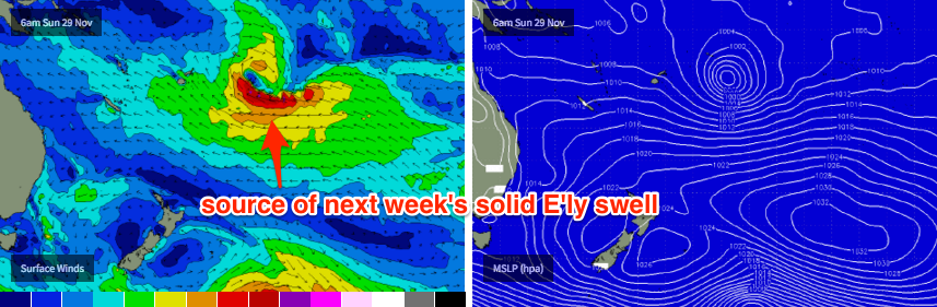
Additionally, the first new signs of E’ly swell will start to build across the entire region, originating from a deepening tropical depression near Fiji over the last few days. We’re expecting a slow, steady upwards trend for the next week or more so don’t expect Saturday and Sunday to offer anything amazing in the size department - but this will help fill out size at those SE Qld beaches unable to rake in much energy from the short range SE swell.
Southeast QLD: Expect building SE swell and E’ly swell through Saturday, before easing slowly into Sunday. Most beaches will initially see 1-2ft surf on Saturday from both sources, with bigger 2-3ft waves at south swell magnets, however mainly moderate to fresh SE winds will create bumpy conditions at exposed spots. Early SW winds are likely around the southern Gold Coast but open coasts will probably remain lumpy at best for the morning session.
On Sunday, the SE swell will fade but we’ll start to see a little more size form the east. Set waves will be very inconsistent but with some tidal assistance, should push up into the 2ft to almost 3ft range at open beaches through the afternoon. Conditions are looking clean with early light winds, but freshening NE sea breezes after lunch will create bumpy conditions into the latter part of the day (unfortunately, this is the period when we’re likely to see the bigger waves). Regardless, the morning should offer small peaky options at most coasts.
Northern NSW: Saturday should offer some reasonable waves. Winds are expected to be some form of light to moderate E’ly all day, however we should see isolated regions of light SW winds in the morning.
Exposed south facing beaches are looking at the most size with sets in the 3ft+ range at times on Saturday, but it’ll ease throughout Sunday. Expect smaller surf at beaches with less southerly exposure.
As mentioned for SE Qld, we’ll also see a slowly building E’ly swell throughout the weekend but it’ll probably be the smaller of the swell trains in the water, and wave heights will be smaller from this source across the Mid North Coast than the Far North Coast. Sunday morning’s conditions look really good with light offshores, but fresh NE sea breezes into the afternoon will create bumpy conditions away form protected northern corners.
Next week (Monday 30th onwards)
Next week’s surf outlook can be broken down into a couple simple points:
- The tropical system near Fiji will generate a steady, upwards trend in easterly swell all week, reaching a peak around Friday or maybe Saturday. At this stage we’re we’re looking at solid 4-5ft+ sets from this source at its peak, but with reasonable waits between waves due to the lengthy distance the swell will have travelled from its source.
- Northerly winds will dominate the region from Monday thru’ Wednesday, before a southerly change across Northern NSW late Wednesday builds a ridge into the southern Coral Sea overnight, establishing SE winds across the region from Thursday onwards that’ll favour the points for a few days at least.
- A small southerly groundswell will also fill into the region late Sunday (Mid North Coast) and Monday (remainder of Northern NSW), originating from a moderate frontal system below Tasmania today. However no great size is likely.
As for the early-week northerly flow, Monday doesn’t look too bad at this stage with pockets of morning NW winds likely to work in conjunction with a slowly building easterly swell. However it will become bumpy throughout the day.
Tuesday and Wednesday are at much more risk of a damaging northerly breeze, but the timing of the S’ly change may provide some afternoon options on Wednesday along the Mid North Coast. I'll have more on this in Monday's update.
As for the late-next-week-thru’-weekend peak in easterly groundswell: early indications are that we’ve got a great run of solid surf on target for the points. Set waves could posssibly push upwards of 4-5ft and into the 6ft+ range, based on the latest model projections - however the upper end of this size range would be restricted to a handful of swell magnets. Let’s see how the forecast models are stacking up in Monday’s update.
Until then have a great weekend.
Comments
Slim pickings at Snapper this afternoon.
A couple of those east swell magnets could be 6-8 ft with random 10 fters later in the week.......please devil winds stay away
what do you think Freeride ? DS is going to luv it !
Totally unrelated - IMO, 2 spots to watch over the next 4 weeks re tropcal low development is good old reliable solomons - not exactly going out on a limb with that one lol.... But I think eastern side of Solomons.......
The other thing I'd watch for is the Gulf..... In particular, I'd watch for an odd development - A "land low", or deep trough over Qld/NT moving north, being pushed pushed northwards by an early season larger than normal high.... As the dry low/trough encounters the 29'ish warm waters, anything can happen....
These quite rare lows can often turn cyclonic, head ese crossing the cape or even below (townsville), and then deepen again in the pacific..
Yes Sheepdog Solomans yes!!!!
Hey, Mick...... How ya been??
Pretty well. Got married, been getting small waves happy days!!!
Hi Udo very much doubt it will get that big but DS is waiting patiently under house
Hmmm I haven't done a Gold Coast run for a while. Oh look at that, no commitments Thursday or Friday. Am I tempted? Oh yes.
Its going to get super super crowded at the usually locations Every one being wave crazy. #Thinking out side the box.
http://www.usno.navy.mil/NOOC/nmfc-ph/RSS/jtwc/warnings/sh0416.gif
But I think we're relying on the ETT and squeeze against the large high to her south.
Hmmm....SE track obliquely to the circle paths and a fucking long way away....I'm going to temper expectations.
Yes I was dissappointed when I saw no S/SW track.
I think it's helping that the intense component of the fetch is at the front edge of the high pressure fetch. Kinda should kick along further the tradewind swell developed from the high pressure fetch created before the low moves down onto the top of the high.
Don't get too down , Don.... Whatever way you look at it, there'll be groundswell waves from the east bigger than 2 foot lol...... Not bad for first week of december.... Seen worse.....
Cheering at the word groundswell and Queensland in the same sentence after last long months. Hahaha
Boys, can someone enlighten me about this technical point arising from this forecast:-
"..... At this stage we’re we’re looking at solid 4-5ft+ sets from this source at its peak, but with reasonable waits between waves due to the lengthy distance the swell will have travelled from its source." (eg in this instance east of Fiji to say the Gold Coast)
with the fact that swells can travel 2- 3 times that distance to arrive at Indo up to 2- 3 times that size?
You're comparing apples with oranges. My reference to the consistency of the surf is based on the fact that - compared to regular swell producing systems for the east coast - this fetch is located much further away, so the surf will therefore be much less consistent than usual.
This inconsistency is a common characteristic of Indonesian swells so doesn't need to be mentioned with as much emphasis when discussing this region.
As for size, that's all relative to the strength, width and duration of a storm, as well as a number of other factors. So again, you're comparing apples with oranges - this particular storm setup is different to the kinds of weather systems that generate Indonesian swells.
Thanks Ben, I might have been displaying my ignorance with apples and oranges, but on face value, my logic was wrestling with the fact that swells travel much larger distances at bigger sizes and land in a thumping manner for days in Indo. (I accept there are other variables too) Looking at the WAM modelling with a category 1 cyclone dropping into and nestling up against a semi stationary HIGH, it seemed reasonable/logical to wonder why can't this set up deliver a pretty good swell. btw, love you work and not doubting the forecast; just pondering "why can't this deliver a bumper East swell, even tho it's a fair way out..." Fred
Strength length and duration of fetch plus almost impossible to get a captured fetch when the fetch is moving away from the swell direction.
Indian Ocean fetches nearly always move in the same direction of the swell. Makes a massive difference. Not to mention the strength of this fetch is tiny compared to the massive storms in the Indian Ocean / Southern Ocean.
Thanks Don, sounds like the word 'magnitude' comes into play - Indian ocean in winter equals magnitude in terms of strength, scale and duration (say 10/10) compared to East coast summer East swells equals 2 or 3/10. I get it now. Thanks.
Don's pointed out most of the issues. However another contributing factor is the pre-existing sea state of the Southern Ocean. Most large Indo swells are generated by weather systems working on the active sea state generated by the previous front/low (or series of). This greatly assists in furtger increase swell heights and periods.
But in the South Pacific, often weather systems are forming on benign or relatively inactive sea states. So, they're starting from zero, and therefore the responsible fetch requires a lot more strength, width and duration to get the swell up to an appreciable level.
More I look at this fetch the less confidence I have in it. Looks pretty raggedy on ASCAT this morning.
Hype could easily overwhelm reality.
not the first time
Tuni she is.
http://www.met.gov.fj/aifs_prods/65661.html
Earthnull.
No sign of anything here this morning: just a couple feet tops of post storm dribble.
Hate to be Captain Doomsayer but this TD turning into a cyclone is the worst case scenario. The fetch becomes concentrated around the (warm) core and the system usually becomes more mobile compared to a slow moving depression. That means, unless the system moves in the direction of the swell generating winds with respect to the circle paths the fetch becomes duration limited. Thats the great magic secret of the tradewind fetch , the fully developed sea state.
It's why a pretty lame looking fetch can produce days and weeks of fun punchy surf.
Take the fully developed sea state out of the equation and absent a perfect track and these long range cyclone swells don't add up to much.
Rant over, pass me another coffee please nurse.
edit: looks like it fizzles out quickly with another system forming way out near Tahiti.
Just did some more interrogation on observations. Tending to side you with on this one Steve. But will hold my final verdict until latter ASCAT images etc from late last night and into this morning.
Agree with your points Steve, but I still think we'll see good swell from this system, as the fetch length is quite impressive. I may back off size estimates a touch though (from Friday's notes).
Re: today's surf - our Coffs cam was showing a nice mix of southerly and easterly swells this morning, with sets aorund the 3ft mark.
Here's the S'ly swell pushing in long uniform lines:
And here's the E'ly swell. As it wraps around the headland and an offshore island, it breaks the swell lines up into peaks that cycle further south down the beach (see right of surfcam image).
If thats E swell at Coffs shouldn't We be seeing a bit more here on the Sunny Coast. 1 ft maybe 2ft at the swell magnets this morn.tho some lines looking like the longer range fetch. To small to ride really.
It would make some sense that right now we're just seeing a small aberration in the east swell. I was watching a Tweed Coast beachie yesterday dish out solid 3ft sets (head high, even a few slightly bigger ones), so we definitely saw a building trend over the weekend. However, the primary swell source - this Fijian system - is expected to provide almost a week of swell, so it's unrealistic to expect a continual upwards trend (albeit slow and steady) - there'll always be slack periods - and I suspect we're in the midst of one right now. The most difficult part of these near-stationary fetches is working out when these temporary lulls are going to occur.
Ben, that swell yesterday down the Tweed was NOT E'ly swell. Goldy was 1-2ft tops yesterday.
Well there's hope!first signs of 10 sec. E sweĺl on the Mooloolaba bouy
that looks good, helluva lot better than here. Wondering if that E'ly component swell might be left over from the proximate ESE fetch on the weekend.
no swell from tc in the water on the sc yet, just tiny wind waves from yesterdays wind
may see first signs tomorrow or even early Wednesday.
TC swell won't be anywhere near in the water until late this week. Pre-cursor swells are just a beefed up tradewind swell.
And BTW, I wouldn't be really referring to this swell as a TC swell. Without the cradling high, we'd see feck all from TC Tuni.
Don any prediction on what TC may bring ?
I don't publicly announce my predictions much these days for surfing locations too close to home. Sorry udo, but I'm sure you can understand.
Fuck Don, we're talking about SE QLD, the most well known, crowded surfing real estate on Earth under a regime of broad E'ly swell. You're not sending anyone anywhere by making a call on surf size and arrival times.
Thanks Steve....but who said I was going to surf SE Qld!!!
Haha, I'm with Steve on this one, Nth NSW, SE Qld, putting a size and timing on things won't inhibit you on your search for less crowded options, bit paranoid there Don.
No mate, not paranoid. Just observed it first hand. If you're thinking better than the pack then you will get less crowded waves. Experienced it many times.
no-ones taking about naming spots Don.
"donweather - No mate, not paranoid. Just observed it first hand. If you're thinking better than the pack then you will get less crowded waves. Experienced it many times."
OK Ebenezer.
By the way, Merry Christmas. :)
More importantly, when the feck are they gonna get the Byron wave buoy back up and running? Without that, we're all relying on observations like Ben's pics above, which BTW I think are pretty damn spot on for showing the two swells in the water so well done Ben capturing those.
just did a good run around the coast here. Dribble. Which makes me think that the Coffs swell was the result of leftover ESE swell from the weekend fetch.
Sydney buoy is picking up signals of distant E/NE swell but around 11s or so, higher than it should be at this stage of the swell..
I think we should kill any talk of cyclone swells,thats simply ludicrous .
Totally.
Too late, it's already a named system. It's not like we can just wish it away.
I would take a more cautious approach because as soon as people here cyclone swell they get excited. Sure it's been named, but I'd be referring it to a very distant and inconsistent easterly trade-swell, amplified slightly by the presence of TC Tuni.
Peoples ignorance is not my problem, the system is named so it's a cyclone swell. Fuggin hell, if people haven't worked out by now that most cyclones are hoaxes they're dumber than I look.
They haven't, hence why we try and downplay them every year.
Fuck you mob crack me up sometimes.....
Just a matter of time really,i mean they surf with there doggies up here now not much of a stretch to imagine a time when the doggies take to the waves of their own accord:)Yeah stuff it, the Mob is coming regardless..so,cyclone swell it is..Hey did someone say CYCLONE..........
It's a "look at meeee" type of persons dream up there, SM..... Personally, i think anyone who takes their dog surfing with them should be bitch slapped..... perhaps all that doggy stench in the water is bring in the sharks........ lol....... :p
Hahahahaha
Just fix your dings, stop ya whinging, organize an early morning thursday or friday, and go catch some better than usual waves for early December.... 3 foot.... 4 foot.... 4.21597feet... Maybe 1.038 meters.... maybe 11.6648791458 seconds..... 3 wave sets every 10.44589 minutes, but a 4 wave set after six 3 wave sets in a row, followed by a 13 minute lull.... Winds ranging from nw to se..... The tides will be coming in, then going out, then coming back in again...
I hope this is helpful...
Now you've really done it SD ya gave away the game
The beaches around me will be overun
x 2 whoops
you're missing this aren't you Dog....all the cyclone swell hype . I mean there's fukall happening in South Oz.
I haven't seen/heard of any hype...... The only word of "hype" I have seen is right here on SW, Free Ride....
Yeah fuck all here today.... Walked in to a different beach today..... The most exiting part was swallowing 400 flies........ Took a photo, turned around, walked back to the car..... Shithouse but heaps of potential.... Great view from up on the dunes...
mate, you've got to get away from all those churches, feral goat fuckers and nuclear waste dumps and get back to Gods Country.
lol..... What and hang with bearded hipsters eating "quinoa salad with roasted baby beetroot and Persian feta" for only $42.50? Wash it down with a $10 free trade soy decaff latte? Work 2 jobs just to pay the mortgage on a shitbox that I went into debt for over 700k? Surf points I used to have with a handful of mates now with 700 gherkin breaths from take off to shorey?? I've heard "that left" is now fully packed with wankstains in boats, and jetski's, go pro's strapped to their weeners.....
Nahhhh maaaaate....... I'm in gods country....
why do you hate roasted baby beetroots so much?
I love roasted baby beetroots..... But not at $42.50........
Todays little sightseeing..... About a 10 minute walk in...... Not a freek'n lycra wearing boomer or council dog inspector or quinoa muncher in sight..... Should've taken a rod, FR..... Some really decent gutters and banks...
looks like good mulloway country. west coast?
Nice and quite. Like the head land I am heading to hoping its wrapping around be some long rides happy days.
Not saying FR...... With the pic taken at midday, and the sun directly above, could be west coast, but it could be facing se, sw, nw....... Who knows...... ;)
whats a bloke do to earn a crust in South Ozzy?
apart from fitness training and tuna farming.
.
FR, I am working for the family again..... I can't say which media/advertising outlet, coz I might blow my cover lol....... Mostly phone blowing/advertorials..... Back to the fucking future..... But hey, my little brother is easy to push around, the boss you have when you haven't got a boss...... Sell a grand on the phone in a day - 30% commission.... small retainer... Set one room up as an office.... Do that 3 days a week, and cruise....... Have to bust by nuts 6 days a week up your way just to cover bills........
The part of S.A I am in seems ok..... Fair bit of activity.....