Can the synoptic outlook get any more complex?

South East Queensland and Northern New South Wales Surf Forecast by Ben Matson (issued Friday 9th January)
Best Days: Entire period: plenty of quality trade swell, with workable winds (except the Mid North Coast). There's also still a chance for a decent E'ly groundswell but probably not until later next week.
Recap: Pulsey trade swell with periods of really fun waves both days. Whilst afternoon winds were onshore, Thursday morning saw light variable winds in most areas apart from SE Qld where they were S’ly. NE winds have ramped up this afternoon across the Mid North Coast, but strengths are lighter (and more E’ly) in the north.
This weekend (Jan 10-11)
The weekend forecast is pretty straight forward - slowly down on Saturday and slowly up on Sunday. With no major pressure gradient across the SE Qld and Far Northern NSW coastlines, winds should be light/variable early here but freshening onshore throughout the days.
In the south, an approaching trough will tighten the pressure gradient across the Mid North Coast, resulting in strengthening NE winds south of about Coffs, so expect marginal conditions here at times.
Saturday’s easing swell will be - as per the last few days - biggest on the Sunshine Coast (say, inconsistent 3ft+ sets at open beaches), with slightly smaller waves with increasing southerly latitude.
Sunday’s increase will originate from a strengthening trade flow SE of New Caledonia at the moment that is retrograding very slowly (to the west). This should provide a slightly more uniform size range to the region, but we’ll still probably see the biggest waves across the Sunshine Coast in the afternoon as the swell continues to build (in fact we’re looking at a peak in size on Monday).
I’ve pulled back my estimates a shade since Wednesday, we should see 3-4ft+ surf on the Sunshine Coast late in the day (smaller earlier), 3ft+ on the Gold Coast and then 2-3ft+ across most of the Northern NSW coast.
Next week (Jan 12 onwards)
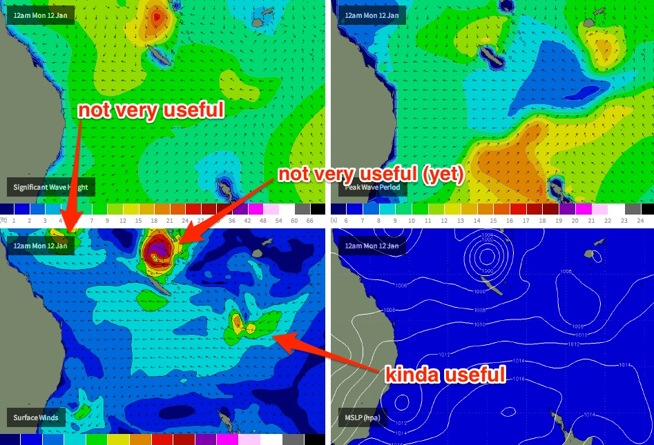
Jeez, we’ve got a complex period ahead in the weather forecasting department. And unfortunately we’re no closer to having a great deal of confidence on the prospects of a significant swell event for any section of the East Coast.
All of the ingredients are still there but the various computer models are still quite erratic between model runs and there’s too many possible scenarios that could play out.
Key features are:
1) a steady supply of quality trade swell through until about mid week at least (and probably the weekend), sourced from a ridge between New Zealand and New Caledonia. It’s likely to weaken early next week but could potentially be reinvigorated shortly afterwards by a southward tracking Tropical Cyclone. Regardless, we should see at least 3ft of trade swell from this source (bigger at times in SE Qld near 4ft+) for most of the forecast period and beyond.
2) a strong southerly change into the lower Tasman Sea around Wednesday (thanks to a low SE of Tasmania), with an associated increase in punchy southerly swell for exposed south facing beaches in Northern NSW on Thursday.
3) Tropical Cyclone developments in the Coral Sea, although the prospect of a NE groundswell around Tuesday or Wednesday (as discussed in Wednesday’s notes) have diminished quite a lot.
Obviously, we’re all focused intently on the prospective TC developments up north. Right now the models still agree on a couple of features:
1) the evolution of two separate systems, one near the Solomon Islands and the other embedded in a vigorous monsoon pattern crossing Cape York Peninsula
2) the Solomons system will probably track southwards, then southeast into the swell shadow of New Caledonia, before possibly becoming embedded in the broader existing trade flow (but from there who knows whether it’ll slip to the south east, forever to be forgotton, or stall and become significant swell generating system for us - either option is plausible and suggested by some of the models)
3) the Cape York system will meander about the Northern Coral Sea for a few days, and is unlikely to be useful for us (swell potential wise) for quite some time, if at all
The GFS model is maintaining a small degree of hope that during the Solomons system’s initial southward track, that it may display gale-to-storm force N’ly winds about its eastern flank for a day or two.
Whilst this scenario - if it happens - could technically occur within SE Qld’s rare NE swell window, there are several factors working against a decent swell event happening: (1) the lack of a supporting ridge to draw out the fetch length (the core winds around the cyclone would be too short for significant groundswell production, no matter how strong), and (2) the cyclone’s steady S’ly then SE track would generally be across the preferred great circle path, further inhibiting swell production.
So, in short: hang tight, and wait for Monday’s forecast update. If there are significant changes to the model data over the weekend I’ll update this forecast in the notes below. But at this stage the most likely scenario is for a week or more of really fun, pulsey trade swell.
I’ll detail all of this more comprehensively in Monday’s update. Have a great weekend!
Comments
Re' Cape York "not very useful".... I agree for now.... Not even good for FNQ barrier reef too close, too windy..... But that system may hang around like a bad smell ( like you said), toing and froing, interacting with other smaller embedded cells over the Cape/Townsville.... Could become a player further down the track....
Was getting excited about that northerly groundswell. Any hope left?
Rees0, mate... Most charts have the low slipping down the wrong side of New Cal'.... Bit of a piss off... Just keep watching the charts in case the low heads due south - on our side of New cal, not Fiji's.... That's the only hope... Real long shot...But hey, stranger things have happened....
Cheers SD was going to clear work on tues too. One of these days...
What a frizzler would love to here a swell getting upgraded feels like the bubble always busts
Cyclone track for the Solomons system not looking good as per official BOM chart.
No cradle either.
Pppppfffftttt
IMO there are too many models out there for people to froth on, way in advance.
Keep it simple go down the beach or look out the window and have a go.
Gday, boys... If you want swell from this solomons system, probably pray to the accessg huey, as it has a possible merger on Tues - solomons low and smaller low east of New Cal - an ok fetch below New cal...
If the low off the cape is more your style, then a sacrifice to the gfs huey is in order... Some really interesting scenarios with that one and an inland trough running north - south... On gfs, the low is predicted to move west over Innisfail back towards the gulf, then fester for several days.. Next Friday, a high pushing in from sw WA helps push all of this tropical muck east.... This is when things could become quite interesting for SEQ...
Anyway, Donny..... Looks like a cyclone will form at 159/13.... Now AGES and AGES ago, I said a circle, 600km radius, 163/12........ A quick calculation - 448km... With that own goal of donny's (wa/nt cyclone), at the 5 minute mark of 2015, and the sheer hail maryishness of the solomons call, the dawg skips ahead 3 nil...... ;).... And yes, I am an annoying prick of a man...... But deep down, you love it..... :p
Yep SD....well done mate. You did well for sure with this long range prediction. HOWEVER, I'm only giving you half a cigar, or perhaps even a third of cigar for the following reasons:
1. Your original prediction was for tropical cyclones in the Coral Sea and/or the Gulf. Neither of which has occurred. You then subsequently changed your prediction to tropical depressions.
2. You also said (when I was predicting the WA cyclone) that you couldn't give a feck about that system as you were only interested in systems that generated swell for SE Qld/East Coast. Unfortunately, I can't see any noteworthy swell coming from these systems for SE Qld or the East Coast.
3. I'm a cvnt of a hard marker!!!! ;)
BTW, you rubbished my WA system as you weren't interested in it given it wasn't going to generate any swell.....but isn't it this WA system that's about to unload your SE swell for Tassie that you're getting excited about?
Geee.... Thanks, Don......... Hmmm, ok... Hard marking time for Donny... ;) Pulling out the red texta for some c*nt of a hard mark, nnnnnnnnnow....
"Your low" is still over the Nt... The one about to ruin our cherrys spawned out of a trough... lol..... Your low is still sitting there blocking highs.....
Full cycle here-
http://www.bom.gov.au/australia/charts/synoptic_col.shtml
Trying to con the headmaster, Donny... Extra demerit..... D for D minus....
As far as the coral sea goes, I'm not totally writing it off yet... Accessg and Gfs have been shocking this week.... ABC24 even drew in a cyclone this morning... You said "SE Qld or the East Coast."........ I would consider Fraser island and north of there as the east coast :) .... I personally consider SEQ to end around the A**** W**** area... And during east or ene swell events inside New cal, it's amazing how many folk disregard this area....
I'll give it another 24 hours, Don....
So you are set in stone?? Don't wanna sit on the fence with me for 24 hours? Last chance.....
Nah mate, not set it stone. Just wanted to get in early to rub some salt in!!! ;)
hahaha... yeah... You're good at getting in early... Saw that with your wa/nt cyclone call.......... ;P Jokes aside, it's a real food blender out there at the mo'..... Sure beats watching winter highs and praying for ecls.....
Don, gfs has an interesting "prediction" for thurs/Fri, as that low merges with another ne of NZ.... Just in seq window... We saw a few small to medium sized but good quality long period swells from that area last year... We'll see.
I'd still keep an eye on the gulf over the next week or two....
Any y'all know if the BOM 4 day forecast and MSLP analysis charts use the same projection? I.e. if I drew imaginary lines WSW of Bass Straight could i expect them both to take the same path? For the purpose of comparing systems by eye...
Hows that trough line extending down from Perth to the 50th Parallel on SD's BOM chart above . Crazytown .
On a side note: sorry for the delay in this evening's report - I got struck down with small case of gastro this afternoon whilst preparing the Sydney report (kids had it yesty) - and I've had to spend some time recuperating ever since. I'll get cracking on the forecast shortly.
hows that eastside madagastro forecast while your at it .
madagascar sorry ben
Haha, get him while he's down ay Camel!
That cyclone off Madagascar turns into one hell of a swell produced once that supporting ridge strengthens to its south.
Haven't seen something like that ever I'm pretty sure. First short-range E/SE-SE swell and then larger pulses of E/SE groundswell!
I was watching a show on SBS about a couple 4wd'ing on the east coast of Madagascar. Fcuking unbelieveable looking coastline open to trade and cyclone swells.
be a good time to be there youd get surfed out
Madagascar dangerous as, horrific crimes against tourists.
Sharks ...... That's the response I got from a mate who travelled through there .
Could imagine, especially with all the activity around Reunion.
Mozambique would be a great option also once the cyclone (Bansi) slips south of Madagascar's swell shadow.
Hey just wondering when the report is going up ?
Ben came down with something yesterday afternoon and is still crook today.
Basically we're looking at easing levels of E'ly trade-swell right through this week, with a small and inconsistent kick in long-range E/SE energy Saturday and Sunday.
Poor conditions tomorrow with N'ly winds, good for the beaches Thursday morning with offshore NW winds ahead of a late shallow SE change that probably wont reach the Sunny Coast, while Friday should see light morning S/SW winds ahead of E/NE sea breezes.
The Northern NSW coast should also see small and inconsistent levels of S'ly groundswell Friday and then again later Sunday/Monday.
Hahahahahahahaaaa ...
Perfect timing ... just as the swell hits the Qd points Ben is ah "cough cough" coming down with something!
The good 'ole surfers sickness ... AWESOME. ;)
No worries thanks for the report Craig.
Yeah sorry guys - been crook as a dog all day. Seems to be passing now so should be back on deck tomorrow.
Getting better as the swell drops, hey Ben ;)
Sharks.....
Horrific crimes against tourists.....
I know what that's code for!
;)
I posted , but somehow it disappeared this morning .
S'dump ... google Sharks NE Madagascar ( I haven't , but it has been relayed to me numerous times ) that the region is the most dangerous spot on earth for Bull sharks and god knows what else ie Hippos's , croc's etc .... I'm sure if the rumours are true yo'll find your answer somewhere online .
[ PS. 5 min search showed swimming is banned , and has been longer than RI . ]
Wow, crazy!
Pretty full on weather down here..... Howling onshore though.... MickF - East coast NZ would be on the pump.....
Another thing for keen weather watchers to note are 2 developing weak lows through this week, 1 in the lower gulf of C, and another below it over inland Qld... Some charts suggest a merger and eastward movement off the Qld coast in the Mackay/ Rocky region early next week... Perhaps Ben and Craig have some more info on that....
Nice swell for you Sunday though SD!