Easing S'ly swell followed by a building NE swell

South East Queensland and Northern New South Wales forecast by Craig Brokensha (issued Wednesday 13th July)
Best Days: Thursday morning, Friday morning, early Saturday on the North Coast, later Sunday, Monday
Recap
Yesterday started off fun across the North Coast with a moderate sized short-range S'ly swell and offshore winds, while the Goldy was in the small 1-2ft range with a small background E'ly swell.
A stronger S'ly groundswell built into the afternoon but conditions were poor with a fresh and gusty S/SE breeze across most spots.
Today the S'ly swell was hanging in around 3-4ft at south facing beaches with much smaller waves in protected spots, and winds were less favourable and fresh from the SW early across selected breaks before strengthening from the S'th.
This week and weekend (Aug 14 - 17)
S'ly swell pulses will continue to dominate the coming days with a couple of pulses due through the end of the week ahead of one final S'ly groundswell on Saturday morning.
This is related to a node of the Long Wave Trough moving slowly east through the Southern Tasman Sea directing front after front through our southern swell window.
The biggest pulse of the period is due tomorrow morning, keeping south facing beaches on the North Coast topped up with 3-4ft sets before easing slowly into the afternoon. The Goldy should continue in the small 1-2ft range at open beaches, with bigger sets at exposed spots.
A drop is then due into Friday but come Saturday the final long-range and inconsistent S'ly groundswell pulse should fill in. This should push exposed south facing breaks back up to the inconsistent 3ft range before fading through Sunday.
Winds will remain less than perfect tomorrow with an early SW breeze expected across most locations (fresh S/SW on the Goldy) before swinging fresh to strong S/SE into the afternoon.
Friday looks cleaner with a better W/SW offshore due across the North Coast and SW winds on the Goldy with lighter E/SE winds into the afternoon. Moving into Saturday, light offshores should continue across the North Coast, but the Goldy is likely to see a more variable breeze early before strengthening NE winds develop across all regions into the afternoon.
This NE'ly will be related to a deepening inland surface trough slowly moving east and squeezing against a strong high pressure ridge in the Tasman Sea.
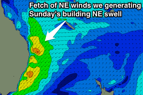 As the trough starts moving further east a tightening northerly pressure gradient will be seen, with a fetch of strengthening NE winds forecast to be aimed directly at us through Saturday afternoon/evening before the trough moves offshore Sunday morning along with the fetch.
What will result is a steady increase in NE windswell growing into short-range NE swell, reaching 3-5ft across north-east facing beaches during Sunday afternoon (much smaller at remaining locations and tiny at south facing beaches). Winds are expected to be poor Sunday morning and fresh to strong from the N/NE along with poor weather and torrential rain, but with the trough moving offshore during the day, winds should also swing offshore from the NW to W/NW through the afternoon (probably later on the Mid North Coast).
With the trough moving offshore, a drop in swell is then due into Monday out of the E/NE, but there should still be plenty of size around as a fetch of NE gales are still generated mainly in the North and Mid North Coast's swell window Sunday evening.
Open beaches should ease from 3-4ft, while the Goldy is expected to see smaller easing 2-3ft waves. Conditions should be great though with a fresh and gusty W'ly breeze.
Longer term we should see some new S/SE swell mid-late next week on the return flow of the trough turning into a Tasman Low in the Southern Tasman Sea, but more on this Friday.