Small weekend ahead of a solid week from the south

Southeast Queensland and Northern New South Wales Surf Forecast by Ben Matson (issued Friday 27th June)
Best Days: Mon/Tues/Wed/Thurs: strong S'ly groundswell, biggest Tues/Wed.
Recap: Plenty of directional south swell across the Northern NSW coast on Thursday, around 2-3ft at exposed south facing beaches (and much smaller elsewhere), although tiny elsewhere. Smaller surf this morning although a small secondary pulse has made its way up the coast during the day (not quite reaching the heights seen Thursday). Very small waves in SE Qld over the last few days although there were a few clean little waves this morning at exposed beaches. Generally clean conditions with offshore winds.
This weekend (June 28-29)
Not a great weekend for surfing anywhere really. The existing small south swell is expected to ease from Saturday morning onwards, and it’ll become almost flat through Sunday, assisted by strengthening NW tending W’ly winds. Your best chance for a surf will be at exposed south swell magnets early Saturday morning. Otherwise, keep your expectations very low.
Next week (June 30 - July 4)
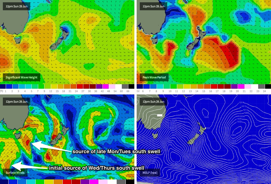
The Long Wave Trough is expected to amplify across Tasman and then New Zealand longitudes early-mid next week, and the upside of this is that its western flank should be positioned inside our southern swell window. This means that rather than having short-lived fetches within flukey parts of our swell window, we’ll have a much broader range of S/SW fetches working from polar latitudes right up into the southern Tasman Sea (see image below).
This is expected to result in around four days of strong southerly swell of varying size and quality, from Monday thru’ Thursday; even Friday should see some small trailing energy off the backside of this pattern. The only (slight) downside is that the overall wind regime will swing more to the SW (following on from morning W/SW winds at many locations), and there’s a risk that we’ll see some periods of S/SW thru’ S’ly winds (Tuesday afternoon and Wednesday looks to be the most likely day for this, especially in the north). However we should see plenty of size with some good refraction into sheltered spots.
Set waves should reach somewhere in the 4-6ft range at exposed south facing beaches throughout this period, which may kick in as early as late Monday along the Lower Mid North Coast but most locations will see a peak through Tuesday and Wednesday. Slowly easing surf is then expected form Thursday onwards.
As per usual, expect smaller surf away from the North Coast's south facing beaches, and it’ll remain very small across most Gold and Sunshine Coast beaches due to the dominant southerly swell direction. That being said, the handful of super exposed south facing beaches in SE Qld should pick up 2-3ft+ sets at the height of the swell (later Tues/Wed); the only risk here is that southerly winds may kick in on Wednesday that’ll have a negative influence on surface conditions at these locations. Still, it's a small bump in size during what's been an extended period of very small conditions north of the border.
Long term (July 5 onwards)
Nothing of significant beyond next week’s long spell of south swell, but I’m sure we’ll see something materialise by Monday’s updated forecast notes. ‘Till then enjoy the weekend and prepare for some good surf from Monday morning onwards.