Plenty of waves for the short term

Southeast Queensland and Northern New South Wales Surf Forecast by Ben Matson (issued Wednesday 11th June)
Best Days: Thurs: good SE swell, best across the Mid North Coast as it'll have the most favourable winds. Fri: clean beachies early with light winds. Fri PM: strong new SE swell but may only reach the Mid North Coast before dusk. Sat: Strong, easing SE swell with a W'ly change before lunch (best in the a'noon, although the swell will be easing). Sun: small clean beachies.
Recap: Peaky mix of swells across the coast - short range SE energy in the north and some mid range SE energy in the south. Generally average conditions at exposed beaches with fresh and gusty S’ly winds winds. A new SE groundswell has just hit the southern NSW coast and will arrive across the Northern NSW coast overnight.
This week (June 10-13)
The new SE swell expected to fill in tonight will produce the best waves about the Mid North Coast on Thursday, as winds will be light and variable here (a lingering SW tending SE flow will occupy waters north of about Yamba). Set waves should approach 3-5ft at exposed south facing beaches but protected spots will be smaller; that being said the swell was showing a respectable wavelength off southern NSW beaches this afternoon so the exposed points in the north should pick up some good runners.
Unfortunately, this swell will have a reasonable percentage of south in its direction so most SE Qld beach will remain on the small side (inconsistent 2ft+ sets) and although south friendly locations will be bigger, they will be wind affected. So expect small peelers on the exposed points as your best option on Thursday.
Friday will generally see a mix of easing SE swell and a small new SE swell (mainly across Northern NSW), the latter originating from a fresh fetch that developed within a broad trough off the West Coast of New Zealand yesterday. Set waves should hover in the 3ft+ range at exposed beaches in Northern NSW (smaller in SE Qld again) with early light variable winds tending N’ly in the south and NE’ly in the north throughout the afternoon.
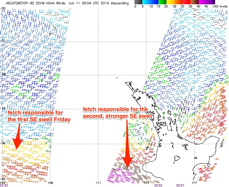
In fact, this NZ trough has produced two separate fetches that have generated two individual pulses that’ll arrive during Friday - however the second pulse will be the stronger/larger of the two, and I’m a little concerned at the prospects that only the Mid North Coast may see this new energy arrive before darkness falls (it’s expected to kick in across the Far North Coast around dinner time, probably too late to be of any benefit).
This second, stronger, long period SE swell will have been generated by the primary E’ly fetch which was picked up by the ASCAT satellite this morning displaying a healthy 40kts (see image below). In fact, this fetch is still strengthening and broadening, and should reach full maturity this afternoon. However, model guidance has slightly pulled back expectations for this system, mainly due to a minor downgrading of the strength of the fetch, its width and also its westerly trajectory. This may also affect the consistency of the swell (which was already expected to be somewhat inconsistent anyway).
As such, I’m going to pull slightly back wave height expectations for this swell to 4-5ft+ across most open beaches across the Mid North Coast, with an outside chance for a handful of 6ft bombs at exposed swell magnets in the few hours before dusk. Wave heights will be a little smaller than this in the Far North - if indeed it arrives before sunset - owing to a slightly less-favourable alignment of the primary fetch. And it’s unlikely we’ll see much of an increase before dusk north of the Qld border, so don't expect anything notable in the water away from the swell magnets on Friday.
This weekend (June 14/15)
Friday’s new SE swell will peak across the North Coast during Saturday morning before trending downwards during the day. Exposed beaches in Northern NSW should see occasional 3-5ft sets at first, however the swell direction cap wave heights across SE Qld around 2ft+ at most open beaches, reaching 3-4ft at the region's small number of exposed south facing beaches early morning. Expect long breaks between the bigger sets, and an easing trend all day.
Conditions are looking best for the afternoon with a moderate westerly change expected to cross the coast during the morning (with N’ly winds prior). So the open beaches will certainly offer the best waves after lunchtime.
Rapidly easing surf will then prevail on Sunday with mainly moderate to fresh W/SW winds.
Next week (June 16-20)
A routine winter Tasman Low is expected to develop off the southern NSW coast this weekend, and will generate a strong south swell early next week - probably reaching the Mid North Coast later Monday, filling in across the North Coast by Tuesday morning and then easing through the afternoon and into Wednesday.
Only south facing beaches will pick up any notable size, with remaining locations likely to be small due to the swell direction. Conditions should be good with mainly W/SW winds.
Looking further ahead and there’s nothing significant on the charts beyond the middle of next week at this stage, but I’ll take a closer look at this on Friday.
Comments
So are you leaning towards ACCESS G/EC with respect to the movement of this trough and formation of a Tasman low over the weekend Ben? I'm specifically referring to local winds as opposed to any real swell from the Tasman low over the weekend.
Well EC's been continually forecasting this fetch to be aimed more so at our southern brethren and it looks like its coming to fruition as we speak.
To be honest I've been splitting the difference. GFS has had slightly stronger local winds but I've pulled back from this a touch.
Fair enough then. Thanks.
hahaha how good is the shot of the pelican and seagull today
No updated forecast?
Got snowed under with things yesterday - will have an update this afternoon. Sorry for the delay.
Guess you were busy again.
Geez was surprised this morning, went for a walk with little NinjaGirl along Palmy.
Every say 15 mins just before High tide solid 3 foot sets, very straight and lined up but, a couple overhead for sure. Very surprised, looked more Easty direction to me....? Also from a long way away...?
Anyone elses feed back on that...?
Swell is def not east, it's south with maybe a touch of east.
Weird all the buoys have that east direction.
Look at the D'Bah cam it's coming in over the bar and into the beach from the south.
Byron spectral shows it's S/SE and the uptick in size is the same as Tweed..
Craig, check the Byron buoy this morning around the time Welly was down the beach. it certainly wasn't from the south then. It was the long range E/SE groundswell from the E/NE of NZ Friday/Sat last week. S'ly swell didn't filter over the border until close to lunch today.
Yep, I see it.
Cheers Craig, just an observation champ, love ya input ;)
I never really know what direction sometimes when on Palmy, it is so tucked away but like you have just documented swells can bend. Cheers
Geez 15 secs...? That coming from somewhere a long way.........?
Coming from a deep Taman Low that formed off the Southern NSW Coast yesterday. Surf this morning in Sydney was 6ft+ at exposed south facing beaches, but kicked to 6ft later yesterday as well.
Just checked ASCAT, there should be some distant E/SE groundswell in the mix from a low over the back of New Zealand and that could be it, but sets overhead seems too big.
Quote Craig "but sets overhead seems too big"
Yeah I know Craig but trust me I witnessed this. I would not say overhead unless I saw this for myself, as I seen 2 guys take some drops and they were overhead, solid 3ft IMO.
I under call wave height as well..?
Just letting you guys from SN know...? It got under my radar as, I've been down there the last 4 days and had one little broken wing surf that didn't feel too well but I managed to get 3 goodies :)
Cheers
Yeah looks like this one slipped through, not discounting your sighting at all. Go and get surfing!
You'd struggle to get 15 sec period swells from a Tasman low off NSW Craig. The longer period stuff is def from the east.
Not really, not when winds were clocked at 45kts. Reached 13.8s down here so would of grown longer in period further north.
Fair enough then. All SE Qld buoys picked up the forerunners of this new E/SE groundswell late yesterday, and the peak of this swell arrived this morning. Whilst I'm not disputing Welly's observations, I note the Mooloolabah buoy was only around 0.7m this morning so I'm not sure the size difference from Byron to SC is as drastically reduced as SD is implying.
Yeah, Welly's seeing the E/SE swell, just saying periods could be around 15s from the Tasman Low as well.
Agreed
Craig, that's because it's not hitting byron, thanks to north island nz........ But I am trying steer clear of forecast notes, so I'll just post this one time... A tight fetch behind the north Island of nz has created a long period ese swell that arrived today..... Virtually nothing at Ballina, but steadily bigger as you head north out of NZ's shadow..... 3 foot sets Sunshine, maybe bigger at D.I....
All Qld buoys confirm size, direction and period....... Will be gone by tomorrow afternoon.....
http://www.ehp.qld.gov.au/coastal/monitoring/waves/index.php
13/6/14 - 6.22pm - "Cheers, mitchvg.. I don't base my voting on single issues either...... BTW, Between you and me (lol) it'd be worth keeping an eye on the northern end of the sunny coast monday/tues..... I'm not gonna say why........ Just this little tip for you my friend ;) ..... long ese swell, 3 - 4 foot..... Nothing to do with any swell mentioned in the report.... You'll figure it out....
Cheers, bloke"
SD it did hit Byron. Look at the multispectral history of the Byron buoy. This morning at 7am it was recording 1.3m (Hs) @ 13.8sec from 112 deg. Mooloolabah buoy around this time was recording 0.7m (Hsig) at 15 sec from the E/SE.
Interesting stuff, Love it ;)
Yeah it's from that low SD. Unfortunately I haven't been able to update the SE Qld forecast since last Wednesday so this swell effectively slipped under the net (I'll explain in a little more detail in this afternoon's notes).
Cheers, Ben..... Cheers, boogyfever...........
What Boogiefever was not there, it was too big for him, amasingly massive I say :)
was definitely in the water at Ballina SD.
surfed a beachie mid morning with OH sets.......few and far between but worth the wait, specially with a bit of S swell wedged into them. tubuloso.
Good call SD !!!! Geez it looks all time down your way too....
Yeah, nearly back on the horse, Mick.... Was all time at ******* ........ To big at the river by reports......
didnt u also write......
Sheepdog commentedMonday, 9 Jun 2014 at 3:55pmnew
That second system has sped up...... NSW looks like it'll get the best of it..... 15th - 17th.....
so 1 of ur 7 predictions was sorta close, ur other 6 predictions were totally wrong!!!!shitdog.... some advice for free...... if u happen to get something remotely close to almost nearly kinda right..... let the forecast do the talking. dont climb on the roof and start waving ur pin dick all around as if u just cracked da vincis code!!!! problem has always been that u get it wrong as much, if not more than every other forecaster on this site, difference is that the others cop their medicine whereas u lie ,deflect and and deny until u make urself look a bigger tool than anyone else could make of u. dont let me stop u predicting, just dont act like ur shit dont stink..... cause it does...
The second system has come through, boogie fever.... And nsw is getting the best of it... Today NSW was solid 6 foot...... Todays the 16th last time i checked...
I predicted both lows back on the 2/6, if you'd like to go back further,,,
2/6/14
"Don, looks impressive.... Bottomline, somethings on the brew.... Seen warm starts to winter like this before -all 4 maps show heaps of warm moist easterlies.... Big "dead" area between 2 highs off east coast..... Upper level moisture moving in from west on 2 predicted occasions (9th - 11th, 15th -17th) - even that benign ecmwf map you supplied showed inland rain over NSW with no surface system - obviously an upper level trough....... All 4 maps metvuw, bellmere, ecmwf, accessg show strong indications to possible ecl..... one scenario for 11/6 coinciding with upper system, second scenario for 16th/17th with next upper system....... Just a matter of which of the two upper systems, and what part of coast between Townsville and Eden.... Time will make things more clear on that one..."
And time did make it clear..... Both lows formed down near eden...... But bottomline, I predicted both upper troughs back on the 2nd of june.... If you are going to be taken seriously by anyone here, boogiefever, you have to get your facts right.....
so ballina isnt in nsw? its flat remember? N.Z forbid any swell from entering ballina??? bullshit!!....from the 3 or 4 confirmed sightings and the data received from don. poo dog,nasa refocussed the hubble telescope and confirmed that u got ur pin dick out again! put it away,this is why ur not taken seriously by so many shit dog. u predicted swell for the eastern seaboard sometime in june.... well done. i predict a swell for australia, any time between now and 2016, ill narrow it down a bit...2015. if a swell comes in my forecast period, im gonna gloat and wave my cock in the air and tell all of u ad nauseum how right i was. is that how it goes poo dog?
Nah, boogiefever....... Everyone here but you knows the ese swell has come froma separate system, a separate swell altogether, boogie fever..... Most here understand that.......You are the only one that doesn't..... And if you look at the bouys, you can see how the ese swell size increases the further the further you go north from byron.
In fact, the byron buoy isn't even registering any ese swell right now, whereas Mooloolabah still has 1.5m of ese swell coming in......
So, the two lows I predicted on the 2/6 both formed.... Both gave NSW decent swell
And the separate ese swell that I predicted on friday ( that no one else predicted) today also came in.....
Anything else I can help you with boogiefever?
7.30pm, moo'ba has well less than a metre of swell......tweed 1.6m. thats south of moo'ba isnt it? anyways who cares???? only u by the sounds. as i said, i understand.... swell for the eastern seaboard in june....get ur dick out and wave it all about!!!
say hi to gary for me!
SD I'll give you credit. You know you're forecasting for the east pretty damn well and as I've always said you seem to have access to the NOAA computers. But FFS mate sometimes you do have to swallow your pride. Quite a few observations today have pointed to the fact that your E/SE groundswell was pretty much the same size south of the border as it was on the SC today.
And you may have been the only one to call it on the SN forums but some of us like it when these swells sneak under Ben's radar......me included. I can show you an email I sent to my mates last week calling Mon/Tues was gonna be on from the east.
We'll never reeaaaaaaaly know if the swell decreased in size towards Ballina will we, considering bathymetry to teh buoys. Does anyone have a surf report from somewhere like Clarke's or Byron Main, vs Noosa beach to really compare surf? Probably not. Anyway, there was no intention of accurately forecasting the surf between NNSW and Fraser. I think it was just a heads up to say to me, if one of your irregular trips to teh SC can be on the mon/tues, keep an eye out. Don't just assume going sth will be better.
EDIT: just saw Padre76's comment also, guess it was sizey enough down into NNSW
As a general observation the traditional peak months April May for goldy have been shifted back by two months and its starting to get good and consistent in the past two weeks. So maybe you are in for a cracking winter.
Not based on current form.
And Ben and Craig might see it differently but that last system was no ECL.
Don, show me the email...... Ben still should have my personal email, as does Mick if you know him..... The difference is I was confident enough to predict publicly....
Don, so you endorse your mate boogiefever's angle and foul rhetoric, personal filth, re' "swallowing pride"..... Good for you, don.... Show me where you've swallowed yours..... You can hold the moral high ground when you practice what you preach.
Backhanded compliments are seethrough....
Don , I've even tried to be nice and factual to your mate.... But all you take out of the conversation is a chance to highlight "VIRTUALLY nothing" at ballina, but STEADILY bigger as you head north......
Well I'll go your favorite angle , semantics.......
We all know a dominant se swell was in the water at byron..... Have a look at craigs post above...... Not much of a hint of ese in the byron buoy.....
As that Low sat for 1 or two hours just north of NZ, Byron may have had 1 to 3 hours of faint ese swell, which was magnified by the dominant se swell..... Big deal!! 1 to 3 hours of 1m swell is VIRTUALLY NOTHING........ The low moved rapidly behing NZ's shadow, and from late morning on there was feck all ESE swell at byron, but the further you got away from NZ's shadow, the ese swell continued ... In fact the ese swell is till in the water NOW further north...... 24+ hours of ese swell on the sunshine coast - "something"..... 3 hours at byron -"virtually nothing".....
Thankyou, welly........ You are the only one here that didn't want to sit back and enjoy the semantic bullshit...Note that over the past 2 months, boogiefever has not posted anything.... that's right, ANYTHING..... other than foul personal attacks on me..... Nothing in wax on..... Nothing in Wax off..... politics.... NOT ONE POST....... Zilch....Just stalking he dog in forecast notes..... That's all he does.....
Blind boy, stu etc know I dont mind a bit of rough and tumble, as long as facts, and knowledge are being thrown around.... But crass deliberate attacks on character, lies and untruths I will not put up with....
So for now forecast notes can stick it...... Couldn't be fucked pointing out something I can see in the distance, which I do btw.... I'm sure the essence wont be looked at.
Sheepy sheepy sheepy, keep posting what you see on those maps...please..
let the other fuckers rant and wank......no need to respond to them !
you have a GIFT at reading synoptics ol son keep on sharing your info.
Yeah, I reckon too.
Ol school synoptic map man.
Harden up princess! Why does it matter if I comment elsewhere or post pics or not? I'm not here to please u poo dog.i couldn't give 2 fucks about politics or wax on wax off!!! All of us use swellnet in different ways. As for ur mystical swell in the distance.... Get off my coat tail..... I predicted a swell coming this year or next already, it's even written above so get ur own swell! Maybe thats where u got the sheep bit from..... Baaaa..... Just another follower.
SD, I think you'll find that under privacy laws Ben's not permitted to give out your email address to me, and also I'm pretty sure he doesn't have time for this sh1t.
And there's a reason I don't publicly broadcast swells that sneak under the radar.....but because you live and surf in Tassie, those reasons don't apply to you!!! Ask Welly how many people were in the water at Palmy yesterday morning compared to a day when a swells been forecast on here!!!!
And mate, if you don't believe that I respect your wealth of knowledge and experience when it comes to forecasting swells for SE Qld, then that's fine mate, but I do respect you with regards to this and I know you know you sh1t when it comes to forecasting.
But, you do need to eat some humble pie sometimes, particularly when multiple people who are completely unrelated are agreeing on the same thing (ie Freeride posted his observations from surfing yesterday morning......we didn't collude to make this up mate).
And I'll say it for the ummmpteenth time. You cannot rely on swell directions from the EPA Wave buoys, particularly Mooloolabah, Goldy and Tweed. Is it just coincidence that the Mooloolabah wave buoy rose yesterday afternoon and into this morning (apparently it's the E/SE groundswell) about exactly the same time the S/SE groundswell was marching past the coast late yesterday and into this morning? Again the Brisbane buoy shows a marked jump to the S/SE after lunch yesterday.
And as for me admitting I'm wrong, check my posts above mate. I made a statement about 15sec swells from the Tasman low and Craig responded with some information to back up his claim and I then accepted and agreed with his response and moved on. Simple acknowledgement of being wrong and then moving on. Not writing a three thousand word essay to state why I believed I was right. Sometimes one can gain much more respect by acknowledging they were wrong rather than trying to justify all the reasons why they thought they were right.
And my point originally to your comment of "Byron got no swell from the east" was to point out it did get swell. Wave buoys showed it and Steve's observations also showed it. Now your saying, OK, it got swell but only for 1-3 hours. So which is it....no swell or swell for 1-3 hrs which BTW Steve just happened to luck into the exact timing of it's arrival.
And mate, take a compliment when it's given. I respect your opinions when it comes to forecasting and recognise you have a damn impressive talent for forecasting long range swells for the east coast. I just wish sometimes you didn't broadcast them to the masses as I hate surfing with crowds!!!! So I'm being selfish!!! ;)
Quote Don "Ask Welly how many people were in the water at Palmy yesterday morning compared to a day when a swells been forecast on here!!!!"
Spot on there Don so true, I shouldn't of said anything, This morning 20 blokes on the main bank that was worth it...?
Fuck I blew it my apologies.
.
Cmon now Welly, you didn't give directions to any good banks. No need to be so hard on yourself
I was in the same area as Welly the last 2 days and can confirm there weren't nearly as many in the water yesterday compared to today, however Monday's swell was VERY straight and long. Today was probably similar direction, but the walls were not quite as long for the most part. If I had to pick a day to surf that beach, today would've been the day. Seems plenty of others agreed...
I'm gonna ask a swell period question: If the swell period is 7 seconds, you expect set waves every, say, minute. The 15 second swells bring set waves about every 8-10mins. So if these swells are going past the buoy every 15 seconds are they then, due to bathymetry etc, going off to different parts of the coast to make landfall?
Sorry for the basic language, difficult to get what's in my head onto the screen....
Quote kaiser "I was in the same area as Welly the last 2 days and can confirm there weren't nearly as many in the water yesterday compared to today, however Monday's swell was VERY straight and long. Today was probably similar direction, but the walls were not quite as long for the most part. If I had to pick a day to surf that beach, today would've been the day. Seems plenty of others agreed..."
True kaiser, fair call, yesterday was the sneaker, I suppose it's all about getting down there everyday eh, have a quizz.
You'd expect a given swell train- and particularly a set within that swell train- of a certain period and direction to be refracted by the shelf bathymetry and near-shore bathymetry uniformly.....
and likewise swells of different periods and directions to be refracted differently.
There's been mostly multiple swell trains in the water over the last couple of swell events. Hence different patterns of refraction.
Good for wedges and places that optimise phase enhancement for multiple swell trains.
Thanks Freeride. So a wave does pass through every 15 secs, they just go off to different parts of the coast. So is it exponential? Sets in a 7 sec swell are more than twice as frequent as a 15 sec swell (at least it feels that way, but I hate standing in queues so I could be imagining things)
...Or then is the consistency of the swell train the governing factor...
Kaiser you need to understand the definition of the wave buoys.
Tsig (Significant period) = average period of the waves used to define Hsig.
Hsig (Significant wave height) = average height of the waves which comprise the highest 33% of waves in a given sample period (typically 20 to 30 minutes).
So a 15 sec period swell doesn't mean you will have continuous supply of waves every 15 sec (I think that's what you were asking?)
Thanks Don. That's sort of what I was asking. Seems the buoys are a very specific way of providing a very generalised measurement. I think I'll stick to my simple ways of using my eyes to see what the surf is doing.
DW do you know a more detailed, worded form of the formula for Hsig? e.g. The mean of the highest 33% of the individual wave crests? OR maybe: the median of a range from Hmax to (Hmax - (Hmax - Hmin) x .33))? Cheers.
It's really very simple Mitch. The buoy records all of the waves within a data burst (usually 26 mins, don't ask why), and Hsig is simply the average of the highest 1/3 of all of the waves recorded.
Wikipedia has more detailed information if you're interested (seems to be pretty good too): http://en.wikipedia.org/wiki/Significant_wave_height
Cheers Ben. Since consistency in sets is proportionate to distance from fetch (right?); a groundswell which increases Tsig, TP1 and Hsig could be considered as closer range than a groundswell which only increases TP...?
"Since consistency in sets is proportionate to distance from fetch (right?)" - as a general rule, yes.
"...a groundswell which increases Tsig, TP1 and Hsig could be considered as closer range than a groundswell which only increases TP...?"
Hmm, interesting theory - I hadn't directly thought of it in this way, but it would appear to work in many cases.
However Tsig will always increase with a new swell - and during long range groundswells, there's a varying lag time between the J-curve on Tp compared to Tsig, so you'd have to crunch the numbers to establish some kind of relationship.
That being said, there is another way to calculate consistency that we're working on here behind the scenes. Not sure if it'll ever produce anything worthwhile but I have been (slowly) working on a couple of related ideas over the last few years.
My point was kind of just more to confirm that the ESE swell is easily masked. But yes also probing about trends the graphs which are characteristic of certain swell types... Thanks
U guys crack me up, you are all obviously well experienced and informed of ocean processes and also have your own interpretations of how these processes play out. A lot like surfing really isn't it, a truly individual connection to the wave/ocean which means all roads lead to the same view- love of surfing/wave creation.
I recently had an interesting conversation with an old mate from Kingy who's daughter is a multiple world champion who informed me he now never looks at any charts or forecasts, but just grabs his board and goes and old mate is just as stoked surfing slop as well as perfection. Food for thought I reckon.
I think you'll be pleasantly surprised that I do the same Dave. Surf it all from 6ft+ perfection to 1-2ft slops. Can't surf perfect waves all the time and you always get at least one decent wave in the slops.
Yeah Craig I know what you're saying but, as Dave just pointed out many a people just go have a look at the beach, maybe they are in close proximity and it is easy.
Craig, surf forecasting is your job and you have the insight regards to many here, well in advance and you probably know what you are going to expect.
I have to travel by car 20-25 mins to the beach, so sometimes I will quickly have a look at the SN forecast for the morning or will know from looking at it 2-3 days ago, what to expect. Saying that many a times I just go, because I don't really care what kind of waves that have been forecasted, as many a times Ive gone to the beach, it is so emotional, I mean places like TOS, you never know what to expect.
So you take it on the chin and just go and surf.
Love your guys dedication to surf forecasting and also love other peoples input, DW, Sheepio, Mitch Very Good etc.
Cheers, keep up the good work, hey its free :)