Weekend o' trade swell aplenty

Southeast Queensland and Northern New South Wales Surf Forecast by Ben Matson (issued Friday 16th May)
Best Days: Sat/Sun: strong tradeswell, biggest in SE Qld. Mon thru' Fri: slowly easing trade swell, biggest in SE Qld. Mon thru' Fri: Small, intermittent long period south swells on the Northern NSW coast.
Recap: Small combo of swells on Thursday, building steadily (mainly across SE Qld) today with a new tradeswell. Freshening E/SE winds in SE Qld and the Far North, but light and variable across the Mid North. Early periods of favourable winds in many areas.
This weekend (May 17-18)
There’s only one major surf focus for the weekend and that’s a building trade swell that’ll peak in size later Saturday or early Sunday, although the overall trend will be slow so there shouldn't be much of a difference either side.
Because of its close proximity to the swell source, the Sunshine Coast will rake in the most size from this event, up to 4-5ft+ at exposed beaches but smaller on the points. The Gold Coast will see smaller waves (say, 3-4ft) with wave heights becoming correspondingly smaller as you head south of the border.
We’re not expecting any swell from the Tasman Sea this weekend, so trade swell will be your only option in all areas. As such expect only small surf across the Mid North.
Wind wise, we’re looking at a mixed bag with mainly fresh and gusty SE winds for the most part, mainly across the SE Qld and Far Northern NSW coasts. There’s a chance for early periods off lighter S’ly winds but overall it’s expected to be quite windy.
Further south from about Yamba, winds will be more light and variable with sea breezes, even tending N/NE across the lower Mid North Coast in the afternoons. But unfortunately these improved conditions will be accompanied by much smaller surf.
Next week (May 19-23)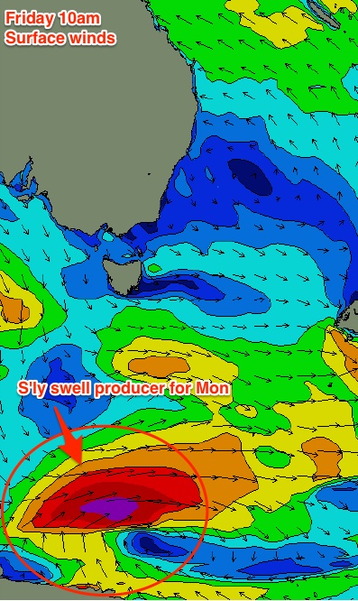
Next week’s surf potential will consistent of two parts. Firstly, the weekend’s trade swell will ease slowly all the way from Monday through Friday, as the trades slowly abate in strength. On Wednesday I estimated that the daily drop would probably be in the order of about half a foot a day (give or take), and that still seems to be about right as per today's model guidance.
Fortunately local winds will also ease throughout this period so local conditions should improve. The overall synoptic flow will remain similar to the weekend (SE in the north, light and variable in the south), just with less strength, and a probable longer period of light offshore winds in all areas early mornings.
Elsewhere, we’ve got some interesting south swell possibilities for exposed swell magnets in Northern NSW next week. Two small south swells are expected to build across the NSW coast on Monday; the primary swell will be related to some highly refracted energy originating from an intense low passing just south of Tasmania on Saturday. It’s very hard to be confident on the likely size due to the poor orientation of this system, however its sheer size and strength overrides this factor (to a degree) and I think there’s a reasonable chance that super exposed south swell magnets could see inconsistent 2-3ft sets. However, very little energy from this source will make its way to protected locations, and there'll be very long breaks even at the swell magnets.
The second source of south swell is already under production at this moment, much further to the south of Tasmania. As per the image to the right, a stationary polar low has formed right off the ice shelf today, and is generating a secondary south swell that’ll fill in behind the first one. It will probably reach the lower Mid North Coast overnight on Monday, showing up best along the Northern NSW swell magnets on Tuesday, with (again, very inconsistent) sets in the 2-3ft range. It’s likely to ease throughout Wednesday.
Unfortunately, our wave model isn't resolving either of these swells very well right now so we'll have to keep an eye on the MHL buoys to tracks its arrival along the NSW coast. Also, I don’t think they'll penetrate into SE Qld at all, but that’s fine because this region will still have plenty of trade swell in the water.
As for the rest of the week, more south swell is expected courtesy of another reasonably strong frontal progression south of Tasmania on Monday and Tuesday. Although not as strong as Saturday’s system, this fetch will be a little better aligned and we should see intermittent pulses of S’ly swell in the 2ft+ range through Thursday and Friday. But there will once again be long breaks between sets.
Long term (May 24 onwards)
Nothing significant standing out in the long term forecast at this stage. Although the trades south of New Caledonia are expected to weaken throughout next week, a second high pressure cell just north-east of New Zealand will develop a new fetch located to the SE of Fiji early in the week, that may supply some small infrequent trade swell later next week and into the weekend. However, no great size is expected from this. More on this in Monday’s update.
Comments
Ben, might be hard to say but what size would you expect in the port Macquarie region over sat&sun? Cheers mate!
'Bout two feet, probably later Saturday and most of Sunday. Make sure you're nicely exposed to the north-east.
Nice jump in swell this arvo,now why should we have sweells coming at us from the ENE up here at the Nth end of the region.Looking at ascat winds are SE out in the Nth Tasman with no Easterlys any where.Refraction? well some times even with a long period ESE it still does'nt make it in to the Points up here,like it sometime does with these SE trade sweels.And it's definitly Nth of East,with 3 Ft sets at the Pot,and the wave bouy at MOObah showing that too.
Another low to form in "el nino alley"..... The umpteenth one this season... Expect long period east to ese swell around Thurs/fri.... 13 - 15 seconds or there abouts..... 3 foot.... Sunny coast in particular...
3ft@15 sec around Thurs? I'd say more likely 11-12 sec around Sat/Sun 3ft.
Don, are you referring to 17th/18th,as in tomorrow? Or 24th/25th? If 17th/18th, that's a given.... Obviously.....
I'm talking about this developing low.....
3ft @ 11-12 sec this Sat/Sun? WTF? C'mon SD, I'm talking about 24th/25th.
Yeah well you better check that low out for yourself, Don.... Fully formed with strengthening fetch this sunday, really booting in overnight to monday..... 6 to 7 days? ok........ I know I call them late but cmon ......
SD are you an employee of NOAA? Cause every time we talk about this the charts move in your favour. Latest 12z GFS run has the fetch closer to the dateline but again not fully ramped up until Tuesday our time. Fetch intensity is also ramped up. So the arrival time now has been brought forward due to less travel distance and longer period. Current arrival time is progged for late Friday afternoon and into Saturday at 3-4ft@13 secs!!! I don't know how you do it SD!!
Thanks, Don. I've got a line to Huey... But he only tells me coral sea stuff.... Wont fill me in on southern tassie.... lol... Oh, last week, when that gutsy south swell hit (swellnet showed hobart points from the air), a mystical left hand point down the road here broke for the first time in ages.... Needs se swell.... Well, broken boards, broken bodies, a real nasty piece of work... Didn't get photos, caught everyone by surprise..... Biggest crowd I've seen here (7)..... A bit like Old woman island at low tide, but with kelp..... Scary stuff...
BTW, you did "get me" re' 17th/18th - 11-12 seconds... lol..... Just assumed you were talking about this weekends swell..... Didnt pay attention to your period..... ... 8 to 9 seconds this weekend..... My bad.... A bit sloppy on my behalf late on a friday night ;)
Re next friday; I'll be a bit more specific now, extra 12 hours to look at charts.... Last nights call was thurs/fri - 13 to 15s, 3f+......... Fine tuned to; swell arriving late thurs (midnightish) initial period in your bracket of 10 to 11s, period increasing during friday to 13+ seconds.. Definitely 13........ Size; well, I hate upgrading, but, I might have to call 4 foot.....
And unlike that last east swell that was butchered by local winds, let's hope the charts are correct and things are a bit calmer up your way....
What day was that SE swell? Thursday 7th May?
Yep.... I should've been more specific..... This spot needs some form of s/e IN the swell.... Not just s/e swell...... Sse, se,ese...... Big BIG south swells also can penetrate around the corner, but they have to be massive, often associated with strong cross shore/onshore into the barrel.....
this spot broke for 3 days.... Almost a record....
I'm just a little surprised that this swell 'caught everyone by surprise' as Craig listed it in his forecast notes the Monday and Wednesday prior, noting it as a "reinforcing and rare S/SE groundswell for (Wednesday) afternoon and Thursday morning".
He even created a specific image for it!
"Caught everyone by surprise" was more of a comment re' taking camera, and the quality of the left..... We expected 3 -4 foot..... Was going to that little spot I sent photos of a while back, but the day wasn't as sunny or photogenic, so didnt take camera...........
http://www.swellnet.com/forums/swellnet-forecast-notes/115551
Ben, you can work out where the left is by looking at the background of the righthander and comparing it to the photos of the left....
But I can tell you it was solid.... I reckon bigger than Craigs call..... Wasn't expecting that.... only seen this place work "properly" 3 times in 5 years..... So charts etc will definitely go into archives.... Must've been the perfect angle for the place, front on drawing every ounce of size and power.... Web photos don't do it justice..... Really hairy eerie dangerous place...... Old deserted graveyard on the headland......
Should've taken the phone at least........ Often no reception down there with my provider....
Dawwwwgio, how about the "ice floe" swell, EC Tas report was pumping! did you get a wave that day? Sorry can't remember exactly which day it was. Mid last week I think
Yeah that's the swell Mitch..... Got a few, but was a bit overawed... Never surfed the left before.... Just caught a few wide ones.... Actual take off was f*ckn hairy for a bloke thats just getting back into it.... If you mucked up, straight onto rock..... I could bullshit and say yeah man got barrelled off my nut, but hey........
Hang on a sec I looked back at the notes...
This was posted on mon 12th... http://www.swellnet.com/reports/forecaster-notes/south-east-queensland-n...
Then I checked the EC Tas reports for a few days, one was pumping.
I think that was different to the above swell, cos Ben mentioned the 7th. Is that right? If so, did that swell (generated on 9th) go good alright for ya?
Well I hope you're on the money SD as I'm going away from Fri-sun of that weekend and I'll literally be 10m from the beach!!!
I'm assuming you've knocked off work from NOAA for the day as the 18z GFS run has just killed your swell!!!
Classic stuff DW :)
Geez yeah SD,
i viewed that wave down Tassie, the one from the air, reminded me of a wave in Mahia which used to break like that in the 80's, right along the railway line... magic stuff
Looking tasty at First Point Noosa this morning.
Donny, the moment you jumped in with 3 foot - 11/12seconds - sat/sun, it became "our swell".... hehehe.... Cross your fingers co sweller ;)
Wellymon. This is the left I was talking about...
oopps
I was looking at SN's FB thingey from the air, but breaking the other way...:)
Looked better than that...... Well?
NOAA employee ehhhhh, classic maybe you should get a full time job with them Sheepio :)
Only for the Coral Sea tho.
It was absolute rubbish on the Goldy today.
Can anyone confirm if Noosa was pumping, I surfed Alex stretch in the arvo, quite hard picking any gems, but the swell was consistent, might join the hoard tomorrow either way i guess.
Boring
SD have you not paid your phone bill as your line to Huey seems rather down at the moment!!!
Noosa's pumping!with crowds, oh yes the Crowd is absolutley pumping,pump pump pumping.Bring Your biggest ugliest board Dromo and join the fun.
And You may have to walk in from as far away as Coolum as thats how far the cars are backed up.
Gee the pick Ben posted above may not have contributed to the crowds at noosa much!!!
Of course. No one had planned on surfing Noosa this weekend until I uploaded a surfcam frame grab.
Ouch!!! ;)
Don... If you are referring to this weekends short tradeswell, I firstly was away for a few days - went to watch my footy team get whipped in melbourne, which was expected..... Didn't post anything for a couple of days..... Pointless talking about it when I got back, cos' it had already been predicted.
Welly, here's another photo of that left 20 minute drive from my place, on a way smaller day. Both photos I supplied are not mine.... From the web...
Nice one Sheepio
Great waves down there eh...!
4/3 steamer in the Winter, wouldn't be as cold as the SI, NZ.....!
Yeah welly, but this left makes noosa look as consistent as Dbah...... long long wait to get it on..... Note photo1 (big day) - on horizon is land on left hand side.... Note photo 2 - land on horizon right hand side....... Tiny swell window..... Has to be s/e and strong.... A rarity in Tassy....
how is it the Noosa food and wine festival gets the only decent wave, whoa be to anyone who drives up that way, with us sunshine coast drivers only coming a close second worst in the state after Mackay, it's a roundabout not a stop sign!!!
Dromo.... You still haven't figured out my tip from ages ago re' noosa.... i can't publicly tell you... A contract on my head would be declared...... I cant even think of a way to cryptically say something, cos it's a dead give away.......
Quote - " It's a roundabout not a stop sign. "
Gold.
Ok ACCESS has been tracking this low dropping down behind NZ NI for a bit now, producing a...
13-14sec swell for arrival mid Thu 22nd.
METVUW is progging a nice, attenuation, of the fetch. But it looks sketchy.
WWIII's peak period is only 11-12secs.
A bit borderline for me, I think I'd rather bank on consistent tradeswell with slackening pressure gradient for the early week.
Make that a nice elongation... not attenuation
Delusion can be a beautiful thing.... I had the nicest dream that I knew something, anything about the weather.
Then I started looking at Swellnet.....and woke up.
I am the only one on here that is lost in this sea of acronyms ?
FFS Blowin, Omg, from my pov it's more than aok to be dac, afaiu...... ;)
Accessg is a weather model - http://www.weatherzone.com.au/models/
metvuw is another weather model - http://www.metvuw.com/forecast/forecast.php?type=rain®ion=swp&noofdays=7
ww111 is the end of the world......... Nahh, another weather/wave model - http://polar.ncep.noaa.gov/waves/index2.shtml
TAB is "totally awesome, beeeatch"
And Boms is "Bitch!! Outta my space!!!!"
:p
good links.
YKW?YCAA = You Know What ? You Cunts Are Alright.
of course we are this is the internets....evryone's right all the time.
YKW,I'm far from it....
Well, that tropical low is being a good girl like I asked her to be :) This friday early, local winds look good re' SEQ.... Slightly inconsistent long range groundswell.... Clean lines....
Should start picking up on thurs'.... Hmmm, sunny coast semi secret spots.... yum.....
I wonder what happened after this? This is from the 17th, just to the NE of NZ. I couldn't follow it onto the next satellite passes, did it just spin off into obscurity, not adding much to the fetch of what might be arriving Thu/Fri? was it spun off from that low behind NZ on the 14-16th?
The swell for this Thursday/Friday is being created today as shown similar to the latest ASCAT pass:
http://manati.star.nesdis.noaa.gov/ascat_images/cur_25km_META/zooms/WMBd...
The fetch intensifies again Tuesday night but this one is further away so it creates the slightly longer period swell but slightly smaller swell for the weekend coming.
Yeah Don that fetch looks further south in a SE QLD direction altho along away away and only 30+ knots, what positions are these fetches important for SE QLD and how strong........? IE between 25 -30 and 177 to 171 as the fetch above in your last post...?
Would like some feed back as I'm just sussing this realm out with your guys posts.
Cheers Welly
rOGER, cheers Don
Is an offset is needed to determine true wind direction at surface level for the ASCAT 25m.Anyone?
Welly, Bom Fiji has issued a gale warning for that area re' low.... e + ne at least 35kn...
SD as you'd know there's a lot more to just wind speed when it comes to swell generating potential. So are you still calling 3-4ft @ 13 sec for thurs Fri?
cheers Sheepio.
Thanks Don........
Maybe 3ft at least thrus maybe friday night
My latest notes are up. I reckon we'll see occasional 4ft sets at the height of the event, probably later Friday and into Saturday - but the leading edge should kick in later Thursday.
Yeah still 3 to 4.... arrival some time late thurs early fri.... swell should last to sat/sun... More size on the sunny coast than Goldy.....
Periods a bit of a worry.... Initial arrival at 10 -11 sec, like I said to you on 17th......... Stretching out to hopefully 13 on Sat.... 12 might be closer to the mark but fingers crossed...You still calling for the swell to arrive sat/sun?
Oh, and Don, what I do like about this little setup is the "double low" atm..... The low further east is already creating swell/active sea state, which is being pushed into the closer low..... Almost a slingshot effect... That combined with the strengthening fetch between the closer low and the high below it means something should rock up.... Inconsistent, but hopefully real nice quality..... As I said, some lesser know sunny coast spots could be real good fri morn if local winds co operate....
Swell def thurs Fri in the 11 sec class. And then another pulse of new swell sat in the 12-13sec class but not as big as Friday. So around 3ft later Thursday and more so into Friday. And 2-3ft Sat/Sun. And I agree with SD. SC should fair better on the thurs Friday swell. But not as good on the sat/sun swell.
SD which low further east are you referring too?