Smaller end to the week, great weekend down South

South Australian Forecast by Craig Brokensha (issued Wednesday May 18th)
Best Days: Today South Coast, South Coast magnets over the coming days, later Saturday both coasts, Sunday South Coast
Features of the Forecast (tl;dr)
- Small tomorrow with moderate N/NE tending N/NW winds (N/NE all day in the gulf)
- Small, inconsistent W/SW swell for Fri/Sat
- Moderate N/NE tending N/NW winds Fri (N/NE all day in the gulf)
- Moderate N/NE-NE winds Sat, easing later
- Moderate sized, inconsistent W/SW-SW groundswell for later Sat, peaking overnight, easing Sun with strengthening N/NEE tending N/NW winds
- Large W/SW swell for early-mid next week with strong winds out of the west
Recap
The surf was solid but bumpy and not great at dawn yesterday across the Mid Coast but winds backed off and conditions improved through the day, fun into the afternoon as the tide filled in.
This morning is much cleaner and a fun 2ft+ still with options all over as the tide rise. The South Coast was a little raw and best in protected spots yesterday, cleaner and better today with a straight offshore wind and sets to 3-4ft across the Middleton stretch.
This week and next (Jun 19 - 27)
Looking at the rest of the week, the current mid-period swell will continue to fade through today, bottoming out tomorrow morning with 2ft waves left across Middleton, while the Mid Coast looks to still be 1-1.5ft or so.
A small, inconsistent, long-range W/SW groundswell may be seen later in the day, though Friday/Saturday are more reliable.
The source of these swells was a distant but strong Southern Ocean frontal progression across the Heard Island region, with slow 2ft sets due across Middleton while the Mid Coast may see 1ft to occasionally 2ft sets on the favourable parts of the tide.
Winds will favour the South Coast magnets with a moderate N/NE tending N/NW breeze tomorrow, N/NE all day inside the gulf, similar Friday.
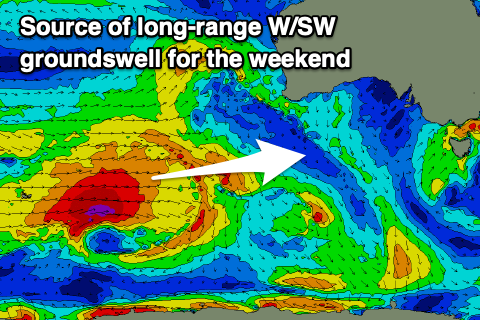
Come Saturday, persistent N/NE-NE winds are due and into the afternoon, a stronger, long-range W/SW-SW groundswell is due to fill in, generated by a great polar frontal progression that formed over the weekend and pushed across the Heard Island region earlier this week while generating fetches of gale to severe-gale W/SW winds.
Last night, the final stages of the progression still saw severe-gale W/SW winds being generated south-west of Western Australia, with a moderate sized groundswell due into later Saturday, pulsing to 3-4ft by dark across Middleton, easing from the same size Sunday morning.
The Mid Coast should offer a bit more size in the 2ft range, though slow and apart from a window later Saturday, winds look to strengthen from the N/NE tending N/NW on Sunday, favouring the South Coast and adding chops inside the gulf.

This strengthening northerly will be ahead of a strengthening and broadening mid-latitude frontal activity through the Bight, with a node of the Long Wave Trough expected to bring sustained, cold, windy weather through early-mid week.
We’re set to see multiple frontal systems pushing east through the Bight followed by polar activity mid-week, generating a large run of W/SW tending SW groundswell under strong westerly winds, easing a little later week.
Check back here Friday for an update on the timings, sizes and local winds for this incoming frontal passage.