Large swell for tomorrow, plenty more to follow

South Australian Forecast by Craig Brokensha (issued Monday May 16th)
Best Days: Mid Coast tomorrow from mid-late morning, South Coast tomorrow, Mid Coast dawn Wednesday, South Coast Wednesday and Thursday, South Coast Sunday morning
Features of the Forecast (tl;dr)
- Large W/SW groundswell for tomorrow AM, easing with moderate W/SW tending variable winds on the Mid in the AM, weak sea breezy, then variable late (W/NW tending weak SW down South)
- Easing swell Wed with early N/NE-NE tending N/NW winds on the Mid, N/NE tending N/NW down South
- Small Thu with N/N/NE tending N/NW winds
- Small, inconsistent W/SW swell for Fri/Sat
- Mod-fresh N/NE tending N/NW winds Fri, fresher N/NE-NE Sat
- Moderate sized, inconsistent W/SW groundswell later Sat, peaking Sun AM with strengthening N/NW tending W/NW winds
- Lots of activity for next week
Recap
The surf was small and slow to kick off the weekend with a further drop in W/SW energy from later last week, while a mid-latitude low moving through Sunday brought with it a kick in poor windswell across the Mid Coast but better waves down South. A mid-period, peaky swell cleaned up and improved through the day, with this morning now seeing super clean but smaller, easing levels of swell.

Fun waves yesterday afternoon
This week and weekend (Jun 17 - 22)
The coming period revolves mostly around the large westerly swell due later today and tomorrow morning across the state, generated by an initially very strong but weakening low moving in from the south-west of Western Australia since Friday.
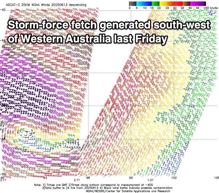
This low was initially tight and generated a great fetch of storm-force W’ly winds, weakening while slowly moving east and under Western Australia, with it weakening below storm-force once pushing under the Bight yesterday evening.
A large W/SW groundswell is now in the water, with it possibly showing on dark today but the peak is due early tomorrow with the Mid Coast coming in at 3-4ft while the South Coast should see 5-6ft sets off Middleton.
Local winds look to improve through the day across the Mid Coast as the low continues east, with a moderate W/SW’ly at dawn due to tend variable through the morning, giving into weak sea breezes and then variable again later.
The South Coast should see a W/NW breeze through the morning, tending weaker SW through the afternoon if not variable later also.
Easing surf is then due on Wednesday from 2ft on the sets across the Mid Coast (mostly 1-2ft) and 3-4ft down South under early E/NE-NE winds on the Mid, shifting N/NW through the day and persistent N/NW winds all day down South.
The swell will continue to ease through Thursday and N-N/NE tending N/NW winds will favour the South Coast magnets.
From later in the day Thursday but more so the Friday/Saturday we’re expected to see increasing levels of small, W/SW groundswell filling in, generated by increasing Southern Ocean activity pushing slowly towards Western Australia, under the influence of a strong node of the Long Wave Trough.
Initial activity will be in our distant swell window and unconsolidated, with Friday/Saturday seeing small, inconsistent pulses to 1ft to possibly 2ft on the favourable parts of the tide across the Mid Coast, while Middleton only looks to come in at 2ft+.
A N/NE tending N/NW breeze will again favour the South Coast Friday, fresher N/NE-NE on Saturday.

Now, later Saturday and more so Sunday, the best of the long-range groundswells is due, generating by a great fetch of gale to severe-gale W/SW winds traversing the polar shelf across the Heard Island region over the coming days, with the activity stalling just east of that region into Wednesday morning.
An inconsistent, moderate sized W/SW groundswell should be seen from this source, offering infrequent 3-4ft sets across Middleton with slow 2ft sets across the Mid Coast and with strong N/NW tending W/NW winds as a deepening trough moving through the Bight edges in.
Now, this trough looks to signal the beginning of a stronger progression of Southern Ocean frontal activity under the country, bringing larger swells from the south-western quadrant mid-late next week.
More on this Wednesday.
Comments
The new swell has just hit the Cape du Couedic wave buoy but it'll not likely arrive before dark.