Great Mid Coast for the coming days

South Australian Forecast by Craig Brokensha (issued Wednesday May 11th)
Best Days: Mid Coast tomorrow afternoon and Friday, South Coast tomorrow morning, Friday, Saturday, Sunday afternoon, Monday morning and Tuesday
Features of the Forecast (tl;dr)
- Large mix of W/SW swells building tomorrow, strongest later, easing slowly Fri (biggest South Coast Fri)
- N/NE-NE tending variable winds tomorrow (E/NE into the PM South Coast)
- E/NE tending N/NE then light NW winds Fri on the Mid, N/NE-NE down South
- Easing swell Sat with strengthening N/NE tending N/NW winds
- Moderate + sized W'ly swell Sun with fresh W/SW tending NW winds
- Strengthening N/NW tending W/NW winds Mon
- Larger W/SW-SW groundswell building later Mon, peaking Tue with W/NW tending NW winds
Recap
The surf was poor across both coasts yesterday with tiny, lumpy waves across the Mid Coast, strong onshore and a mess down South.
Today conditions have improved rapidly on the South Coast with the arrival of a new, inconsistent SW groundswell to 3-4ft. The Mid was still 1ft but lumpy and not great.
This week and next (Jun 12 - 20)
Looking at the end of the week and we’ve got our large W/SW groundswell due tomorrow afternoon and Friday, with a strong mid-latitude low that formed west-southwest of Western Australia now moving in under Western Australia towards the Bight in a weakened form.
This secondary intensification of strong to gale-force W/SW winds will generate some additional mid-period swell for tomorrow, with a building mix of swells to 3ft into the afternoon, easing from a similar size Friday with the South Coast only building slowly tomorrow, reaching 3ft by dark across Middleton with Friday coming in more around 4ft+, easing through the day.

Local winds look great for the Mid Coast into tomorrow afternoon with a moderate N/NE-NE tending variable breeze, with winds tending more E/NE across the South Coast into the afternoon.
Friday looks a bit better for the Mid Coast now (compared to Monday's outlook) with an E/NE tending weak N/NE breeze and N/NE tending E/NE-NE winds down South.
Into the weekend, the swell will continue to ease Saturday with strengthening N/NE tending N/NW winds and easing 2-3ft sets across Middleton, choppy and 2ft on the sets across the Mid Coast.
Into Sunday, another mid-latitude low forming in the Bight and pushing across us looks to bring with it a low-period W’ly swell to 2-3ft with fresh W/SW winds, easing and then tending more N/NW through the day.
Across the South Coast no major size with a long-range inconsistent groundswell being more visible, building through the day to 3ft across Middleton with those improving winds.
Come Monday, strengthening N/NW tending W/NW winds will be ahead of a yet another strong mid-latitude low pushing in from the west.
This low will be slow moving, forming to the south-west of Western Australia later this week before pushing right over towards us through the weekend and Monday.
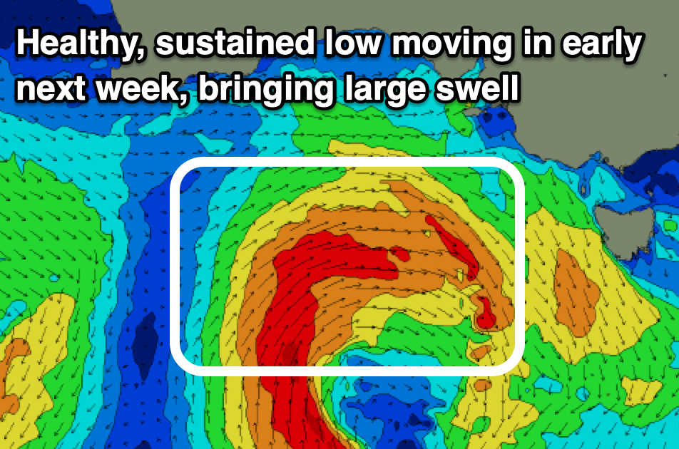
Fetches of strong to gale-force winds should generate a large W/SW-SW groundswell for later Monday and more so Tuesday morning to 2-3ft across the Mid Coast with the South Coast coming in more around 6ft off Middleton.
Local winds look best for the South Coast and moderate W/NW tending NW breeze Tuesday, strengthening from the N/NW on Wednesday as the swell eases.
Longer term the outlook is active with the Southern Ocean expected to produce increasing frontal activity to the south-west of Western Australia, bringing building energy from later next week and more so the following week. More on this Friday.