Flukey week, windy, larger swells from the weekend

South Australian Forecast by Craig Brokensha (issued Monday May 2nd)
Best Days: South Coast today, South Coast for the keen Wednesday morning, South Coast Thursday, protected spots South Coast Sunday/Monday
Features of the Forecast (tl;dr)
- Small with strong S/SE-S winds tomorrow
- Small-mod sized mid-period S/SW swell Wed with fresh NE tending E/NE winds
- Smaller, easing S/SW swell Thu with fresh N/NE tending N winds
- Tiny Fri with strong N/NW tending NW winds (building windswell on the Mid Coast)
- Large W/SW swell Sat with strong W/NW-W winds
- Large S/SW groundswell building Sun, peaking in the PM, easing Mon
- Strong W/NW-NW winds Sun, W/NW Mon
Recap
The South Coast was great all weekend with a good pulse of new S/SW groundswell Saturday morning with offshore winds, still a decent size yesterday morning thanks to a reinforcing swell.
Today is clean again but only small and to 2ft off Middleton, best across the magnets.
On the Mid Coast a small W/SW swell generated by a weak low projecting under WA Saturday is offering 1-1.5ft sets.
This week and weekend (Jun 3 - 8)
Make the most of today’s conditions, as an approaching trough will bring with it a strong S/SE-S change tomorrow along with no decent swell.
The onshore blow will only be temporary, with an approaching mid-latitude low pushing in from the west expected to swing winds back to the E/NE-NE quickly on Wednesday along with some new, small mid-period S/SW swell.
It looks like the models are overcooking the size a little, with a weak front attached to the trough moving through tomorrow expected to generate 2ft to possibly 3ft sets across Middleton on Wednesday, easing back from 2ft+ through Thursday.
The Mid Coast isn’t due to see any major size with tiny peelers expected for beginners.
Winds on Thursday look great and fresh from the N/NE tending N through the day as the mid-latitude low nears closer, shifting strong N/NW-NW on Friday as it then starts to move across us.
Swell wise, the South Coast will become tiny Friday while the Mid will see building levels of NW windswell.
The weekend is a different proposition, with swell generating fetches on the backside of the mid-latitude low expected to move in.
Firstly, a strong front pushing in on the backside of the low, under Western Australia will generate a great fetch of strong W/SW winds through the Bight, kicking up a large sized W/SW swell for Saturday.
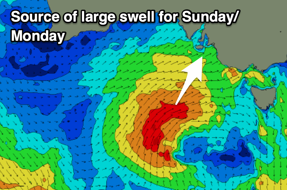
Of greater significance is a secondary front projecting from under the Bight, up towards us and into the low Saturday/Sunday as the low stalls directly south of us.
This will produce larger levels of S/SW swell Sunday/Monday but depending on where the axis of the low sits, winds will either result in favourable though strong W/NW-NW winds or strong S/SW-SW breezes.
At this stage the more reliable European forecasting model has the more favourable winds but we’ll assess this over the coming updates.
Coming back to Saturday and the first pulse of W/SW swell looks to come in at a solid 3ft to occasionally 4ft across the Mid Coast under strong W/NW-W breezes. The South Coast looks to come in around 4ft, with the larger swell for Sunday/Monday likely to 8ft on the South Coast but we’ll have a closer look at this Wednesday.