Average run for the South Coast ahead

South Australian Forecast by Craig Brokensha (issued Friday April 25th)
Best Days: South Coast this morning, Mid Coast tomorrow in protected spots, Mid Coast early Sunday, South Coast Monday morning and later week
Features of the Forecast (tl;dr)
- Moderate + sized SW swell building tomorrow, peaking in the PM with a reinforcing SW groundswell Sun AM, easing
- Fresh to strong S/SE-S winds tomorrow, fresh S/SW on Sun (S/SE early Mid Coast)
- Easing surf Mon with variable tending S/SE winds down South
- Smaller Tue with early W/NW tending S/SW winds
- Small-moderate sized S/SW swell for later Wed, easing Thu
- Fresh E/SE-SE tending S/SE winds Wed, NE tending SE Thu
- Freshening NE winds Fri, stronger N-NW Sat
Recap
The South Coast has offered great waves the past two days with a drop in swell back from the 3ft range across Middleton with favourable winds and conditions most of the day. Today our new SW groundswell has kicked in with great conditions and 3-4ft sets off Middleton with the Mid Coast coming in at 1ft.

Good swell kick this morning
This weekend and next week (Apr 26 - May 2)
Make the most of this morning down South as a trough will bring S’ly winds into the mid-late afternoon that will strengthen into tomorrow as the trough pushes further east, followed by high pressure.
Size wise, our current swell will back off, but we’re set to see some new, moderate sized mid-period SW energy taking its place.
The source was a healthy polar frontal system that projected from the south-west of Western Australia, up under the country the last couple of days, with fetches of strong to sub-gale-force winds due to generate a decent increase in size through tomorrow, peaking later.
Middleton should build back to 3-5ft through tomorrow while the Mid Coast should see 1-2ft waves on the favourable part of the tide into the afternoon, easing slowly Sunday.
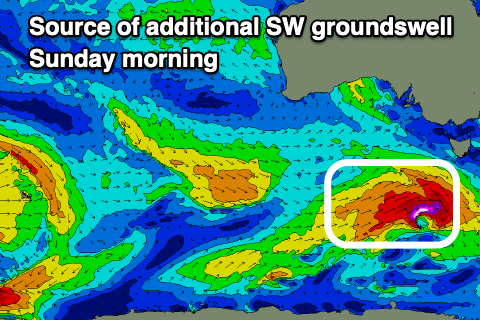
The easing trend will be slowed Sunday by a reinforcing SW groundswell, with it upgraded a little from earlier in the week.
This is thanks to a trailing front generating a small fetch of W/NW gales coming in a little stronger, spawning a low pressure system south-west of Tasmania, late in our swell window today.
This looks to maintain similar sized surf into Sunday morning across both coasts before starting to ease into the afternoon, smaller Monday.
As touched on earlier, gusty S/SE-S winds will favour the Mid Coast tomorrow with Sunday seeing winds shift more S/SW though the Mid Coast should see early S/SE winds again.
Into Monday, a more variable breeze is likely down South through the morning (tending S/SE into the afternoon) with the SW swell energy on the ease, backing off from 3-4ft across Middleton, tiny inside the gulf.
Smaller surf is the due again Tuesday with a possible early W/NW’ly before another trough brings S’ly winds, strengthening from the S/SE into the afternoon/evening and then holding from the E/SE-SE on Wednesday.
Swell wise besides a small to moderate sized increase in mid-period S/SW swell later Wednesday/Thursday, there’s nothing of any real note until the following week.
Winds will switch back to the N’th though into Friday/Saturday, favouring the South Coast with small, easing levels of swell.
Longer term we’re looking at a significant mid-latitude frontal progression firing up next weekend, generating some large W/SW groundswell for the following week, but more on this Monday. Have a great weekend!
Comments
cheers Craig,
hey, what's the deal you south locals with 'Parsons to Goolwa' becoming a designated surf something.. local news just said something officially happens sunday? good thing? what's the goss..
Info in this link:
https://www.facebook.com/surfingsouthaus/posts/after-six-years-of-prepar...
Cheers, mate. middleton point at 11am tomorrow? I'll be there.. can we moon the swellnet cam?