Autumn finally kicking into gear

South Australian Forecast by Craig Brokensha (issued Monday May 20th)
Best Days: Wednesday morning, Friday morning, Saturday, Monday morning, most of next week
Features of the Forecast (tl;dr)
- Easing swell tomorrow with a moderate S/SE-SE breeze, freshening through the day
- Late pulse of new S/SW groundswell, easing Wed with N-N/NE tending E/SE winds
- Easing swell Thu with N/NE morning winds
- Moderate sized, mid-period SW swell building Fri, peaking in the PM, easing Sat
- N/NE tending fresh E/SE winds Fri, similar but weaker into the PM Sat
- Easing swell Sun with N/NE tending SE winds
- Small background SW groundswell later Sun, easing Mon with N/NE tending E winds
Recap
Another strong kick in S’ly groundswell was seen Saturday morning but conditions are a little lumpy and not ideal across the South Coast, clean but tiny in the gulf.
Yesterday saw smaller waves down South with a workable onshore wind that freshened through the day.
Yesterday’s wind was linked to a swell generating front clipping us, with the swell coming in today to 3-4ft down South but with lingering onshore winds, tiny and windswelly across the Mid Coast.
This week and weekend (May 21 - 26)
We’ve got one more average day of winds before we look at an extended run of fun swells and offshore winds. This will be thanks to the blocking high responsible for the run of south-east winds moving more to our east, across Tasmania and into the Tasman Sea, directing persistent north-east winds across the state. The autumn we’ve been waiting for.
But for now, onshore winds will prevail on the South Coast as high pressure sits directly west of us, with moderate S/SE-SE winds due tomorrow morning with a drop in swell from today, back from 2-3ft across Middleton.
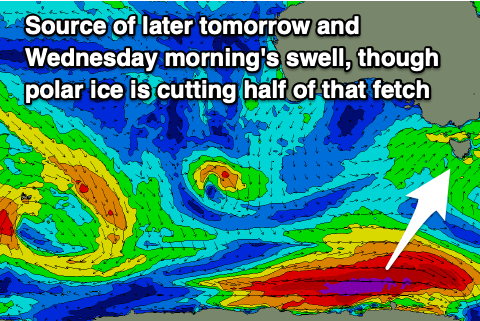
A new pulse of S/SW groundswell due into late tomorrow afternoon and Wednesday morning looks to have been downgraded thanks to the polar low linked to it forming a little later and further east in our swell window.
We should still see a fresh pulse of energy though coming in at 3ft across Middleton later tomorrow and Wednesday morning along with cleaner conditions as winds tip N-N/NE during the morning ahead of relatively weak sea breezes
Thursday looks clean as well with a N/NE offshore but easing 1-2ft waves across Middleton, best on the magnets.

Moving into Friday, and morning N/NE winds are again expected along with a new pulse of building, mid-period SW swell.
The source is a relatively weak but healthy polar low moving under the country over the coming days, generating a fetch of strong to near-gale-force W/SW winds. The swell should build to 4ft across Middleton into the afternoon with 1ft sets likely across the Mid Coast and winds will be favourable most of the day, freshening from the E/SE later.
Saturday looks good as well with the swell easing back from the 3ft range under a morning N/NE breeze, lighter E/SE into the afternoon with Sunday coming in smaller as north-easterly winds persist.
Besides a small pulse of inconsistent, background groundswell fro later Sunday and Monday, we’ll see an active pattern of W/SW swells with those northerly winds into next week, with mid-latitude storms due to fire up towards Western Australia but not make it into the Bight.
This pattern looks to persist until next weekend when one of the fronts finally pushes east, but we’ll have a closer look at this on Wednesday.