Strong swells from the weekend, cleanest in the gulf
South Australian Surf Forecast by Craig Brokensha (issued Wednesday 28th)
Best Days: Keen surfers South Coast tomorrow morning, Friday morning both coasts, Saturday Mid Coast, Sunday Mid Coast, Mid Coast for the keen Monday morning, South Coast Monday morning and Tuesday morning
Features of the Forecast (tl;dr)
- Small surf continuing tomorrow with light W/NW winds down South in the AM, S-S/SE on the Mid in the AM
- Moderate sized W/SW-SW swell filling in Fri with E/NE winds down South in the AM, E/SE on the Mid ahead of sea breezes
- Stronger moderate-large sized W/SW-SW swell for Sat with mod-fresh S/SE winds, strengthening
- Reinforcing, more consistent moderate-large sized W/SW-SW swell Sun with fresh SE winds, strengthening from the S/SE
- Moderate-large, reinforcing S groundswell Mon with E/NE tending SE winds, easing Tue with N/NE morning winds
Recap
Good, improving conditions through yesterday down South with 2-3ft surf across Middleton and favourable winds holding into the afternoon/evening.
This morning is smaller and was best early with clean conditions before winds shifted W/NW and strengthened. This is a little earlier than expected and we'll see winds remaining strong from the W/NW for the rest of the day now.
This week and next (Feb 29 – Mar 8)
Today's strengthening winds are linked to a weakening mid-latitude low moving across us, and this will bring an evening SW change that looks to revert back to the W/NW tomorrow morning and be much lighter. The Mid Coast will likely see light, S/SE winds early.
Swell wise, a tiny pulse of mid-period W/SW swell is due, coming in at 1ft to possibly 1.5ft, with 2ft waves continuing across Middleton.
Of greater significance are the pulses of W/SW-SW swell into Friday and Saturday, with some strong, reinforcing pulses now on the cards for Sunday/Monday.
Friday and Saturday's swells have been generated by a strong polar low that fired up to the south-west of Western Australia earlier in the week.

Friday's mid-period energy was generated by a fetch of strong to gale-force W/NW winds at the head of the low, with a stronger pulse of groundswell Saturday being generated by gale to severe-gale W/SW winds at the tail of the low.
Friday's swell looks to come in at 1-1.5ft across the Mid Coast and 3ft+ across Middleton, with Saturday's looking better to 2ft (on the sets) and 4-5ft+ respectively.
Local winds on Friday look favourable for both coasts, E/NE down South in the morning and E/SE in the gulf, while Saturday will be best in the gulf as moderate to fresh S/SE winds strengthen into the afternoon.
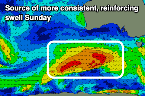
Now, come Sunday a strong and more consistent pulse of reinforcing SW swell is due, generated by a strong frontal system firing up on the tail of the polar low, pushing under Western Australia tomorrow (shown above left). This should maintain 2ft sets across the Mid Coast and 4-6ft surf across Middleton as winds hold out of the SE-S/SE, strengthening into the late afternoon/evening.

One final pulse of strong swell is due Monday across the South Coast, generated by late forming low south of us on the weekend. A fetch of severe-gale to storm-force SW winds should generate a moderate-large S/SW groundswell Monday morning to 4-6ft across Middleton, easing through the day, down from 3ft Tuesday.
The Mid Coast won't see this swell energy, fading from 1-1.5ft on Monday and E/NE winds will start to clean up the South Coast, great Tuesday with a N/NE offshore.
Longer term the outlook is slower into the end of the week ahead of some possible new swell the following weekend. More on this Friday.

