Morning windows of fun surf for the coming days

South Australian Surf Forecast by Craig Brokensha (issued Friday 16th)
Best Days: This morning South Coast, tomorrow morning South Coast, Sunday morning South Coast, Monday and Tuesday mornings South Coast
Features of the Forecast (tl;dr)
- Reinforcing mid-period SW swell tomorrow, with a less consistent SW groundswell for later in the day and Sun
- Variable tending fresh S/SE winds tomorrow, variable early Sun ahead of a S'ly shift mid-AM, slowly freshening thereafter
- New small-mod sized mid-period SW swell for Mon PM, easing Tue
- Light E/NE winds Mon AM ahead of fresh sea breezes, light N/NE-NE Tue AM ahead of sea breezes
- Easing swell Wed with W/SW-SW-S winds
- Tiny Thu
Recap
The better pulse of stronger mid-period swell energy filled in nicely yesterday morning with clean 1.5ft+ waves on the Mid Coast, cleaner but still lumpy 3-4ft across Middleton with winds remaining favourable most of the day in the gulf.
Today the swell is easing with the South Coast being the pick as the swell eases from the 3ft range.
This weekend and next week (Feb 17 - 23)
Looking at the weekend ahead and we've got some fun, reinforcing levels of swell due on the South Coast as the Mid remains tiny.
Firstly a mid-period SW swell is due tomorrow, generated by weak frontal activity passing under the country the last couple of days, then a stronger but less consistent SW groundswell for later tomorrow and more so Sunday morning, generated by a distant but strong polar low.
Sets to 2-3ft are due across Middleton most of the weekend with tomorrow offering the cleanest conditions under a variable morning wind, freshening from the S/SE during the day.
Sunday's window of cleaner conditions looks smaller, with early variable winds likely to tending S'ly mid-morning and then slowly freshen. It'll be OK for most of the morning but keep your expectations in check.
Moving into Monday, light E/NE winds will create lumpy, peaking conditions again with a temporary low point in swell ahead of another mid-period SW swell through the day.
This will be generated by a slightly stronger but late forming frontal system under us on the weekend, with a pulse back to 2-3ft due through the afternoon, easing from a similar size Tuesday morning.
Conditions will be best Tuesday morning with a light N/NE-NE offshore breeze, while fading surf with dicier winds will leave Wednesday and Thursday as lay days.
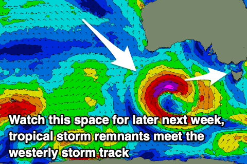
Longer term, we could see a significant low deepening under the country mid-late week, with the catalyst for it being a tropical cyclone drifting from the Indian Ocean into the Southern Ocean storm track. We'll have a closer look at this and the swell possibilities on Monday. Have a great weekend!