There are no standout days this period

South Australian Forecast by Craig Brokensha (issued Friday December 29th)
Best Days: Desperate, experienced surfers Sunday morning down South, Monday morning down South
Features of the Forecast (tl;dr)
- Moderate + sized S/SW swell building tomorrow with mod-fresh S tending S/SW winds, peaking Sun with moderate E/SE tending strong S/SE winds
- Easing swell Mon with variable E/NE tending S winds
- Smaller Tue AM, with a new pulse of mid-period S/SW swell for later, easing Wed
- Light-moderate S/SE winds Tue AM, tending S/SW into the PM, similar winds Wed AM, stronger S/SW into the PM
- Strong S/SE winds Thu/Fri
Recap
Winds were light most of yesterday across the South Coast with a mix of S/SW swells to 2-3ft and fun options for the keen, micro on the Mid Coast. There was also sad news from the Yorke Peninsula. Condolences go out to the family, friends, those who witnessed and the greater South Australian surfing community. Rest In Peace.
This morning onshore winds are up early on the South Coast, creating poor surf with tiny to flat conditions across the Mid Coast.
This weekend and next week (Dec 30 - Jan 5)
We’ve got plenty of size due over the weekend thanks to a strong polar frontal progression moving up towards Tasmania, but there’ll be no real let up to the onshore winds across the South Coast thanks to the front clipping the state, followed by high pressure.
Moderate to fresh S’ly winds will shift S/SW through tomorrow, while Sunday should see winds shift E/SE through the morning down South but remain moderate in strength ahead of gusty S/SE sea breezes.
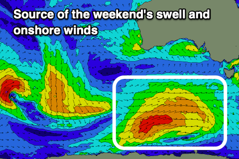
Looking at the polar frontal progression generating the swell, and a good fetch of strong to gale-force W/SW-SW winds have been generated along the polar shelf, with the front now pushing towards Tasmania.
The swell should start building through tomorrow afternoon, with Middleton being 2-3ft in the morning, reaching 4ft later, while Sunday looks solid and to 4-5ft+.
The Mid Coast isn’t expected to really get over 1ft unfortunately.
Monday morning’s window of more variable E/NE winds is still on track but it’ll be relatively short-lived, with a trough due to swing winds around to the SE later morning, fresh S’th into the afternoon.
This looks like the best window for surf though with easing 4ft sets across Middleton, tiny in the gulf.
Some small sized reinforcing S/SW swell is due to arrive through the day Tuesday afternoon, generated by a strong polar front swinging in from the south-east Indian Ocean, generating strong, off-axis NW tending W/NW winds.
The size looks to be around 2-3ft across Middleton easing from a similar size Wednesday morning but with moderate S/SE winds tending SW winds on Tuesday, similar Wednesday but stronger into the afternoon.
With a trough lingering in the region, there’s the chance for more variable winds both Tuesday and Wednesday mornings, but we’ll review this on Monday.
The rest of the week looks poor as high pressure sits south of the Bight, to our west, while polar fronts continue to skirt around the south-east, bringing a return to strong S/SE-S winds.
When will this pattern let up? It doesn’t look to be until possibly Sunday next weekend, but with small levels of swell. More on this Monday, have a great weekend!
Comments
My forecast, guaranteed, first day back at work...offshore winds with a nice swell.
Agree Seabiped.
Although it has been onshore for nearly 8 weeks.
Solid swell on the south coast today and we even got a sunny day.