Poor surf continues this week

South Australian Surf Forecast by Craig Brokensha (issued Monday December 25th)
Best Days: Keen surfers Friday morning
Features of the Forecast (tl;dr)
- Moderate + sized S'ly windswell building this afternoon, easing tomorrow and further Wed
- Inconsistent SW groundswell also in the mix later today and tomorrow AM
- Strong S winds tomorrow
- Mod-fresh S/SE winds Wed AM, easing and tending moderate S/SW
- Moderate sized S/SW swell for Wed, easing slowly Thu and smaller Fri
- Light E/SE winds Thu AM, fresh S/SE into the PM
- Possible variable winds Fri AM ahead of strong S winds into the PM
- Small-moderate sized S/SW swell building Sat with gusty S/SE winds
- Moderate sized S/SW swell Sun with moderate E/SE tending strong S/SE winds
Recap
Merry Christmas!
There were small workable waves across the South Coast for the keen Saturday morning, average yesterday with a moderate onshore wind from the get go. The Mid Coast was tiny all weekend, cleanest Saturday morning.
Today is poor, windy and onshore with nowhere to recommend under strong S’ly winds along with a localised, building windswell.
This week and weekend (Dec 26 - 31)
The current synoptic setup responsible for the poor winds and stormy swell down South is a deep, inland low, squeezing against a strong high to our west, just south of the Bight.

This interaction will continue over the coming days but in a weakened form as the low starts to break down and the high pushes east ahead of weak front moving in Thursday.
This will see winds remaining strong from the S tomorrow, with a poor mix of chunky S/SE windswell and easing SW groundswell.
Wednesday should see winds relax but there’ll still be moderate to fresh from the S/SE in the early morning, swinging moderate S-S/SW through the late morning and afternoon.
Unfortunately there doesn’t look to be much of a window of cleaner surf Thursday morning with winds only easing temporarily while shifting E/SE. With the onshore winds the evening before it won’t be pretty at all and a poor, junky 3ft or so.
Friday morning could offer more variable winds and cleaner conditions and a mix of S/SW swell to 2-3ft along with some weak, easing windswell. We’ll review this on Wednesday as it’s quite a flukey period of winds with the troughy weather.
The Mid Coast will be tiny with some weak windswell generated by today’s winds, easing through Wednesday.
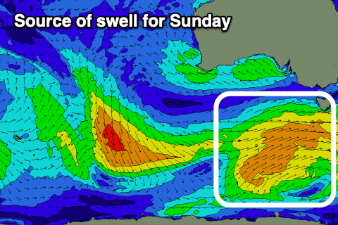
Into the weekend we’re looking at moderate sized + mid-period S/SW swell, generated by a strong and sustained polar frontal progression projecting up and towards Tasmania later week.
This should generate a decent sized swell for Sunday, coming in at 4ft+ across Middleton while only reaching 0.5-1ft max on the Mid Coast.
Conditions will remain poor though as a trough moving in Friday afternoon, bringing strong S’ly winds is followed by a high, shifting winds S/SE on Saturday (still fresh and gusty), with E/SE breezes on Sunday morning for the peak of the swell. Next Monday could be the best chance for a surf with lighter offshore winds but we’ll review this Wednesday. Have a great Christmas!
Comments
Thanks for putting in today Craig
No worries Mitch.
Onya Craig hope you had a good one mate. Here's to hoping we do a hell of a lot better weather and swell wise for next year's Chrissy holidays!
yeh, further to blackers' well wishes, cheers and thanks from this side of the border, Craig. The most un-phoned-in-forecast-on-Christmas-Day we could wish for, especially with the grim outlook. Your work is very much appreciated, happy 2024 : )
Cheers Basesix!