Poor surf continues down South, with hope in the gulf

South Australian Surf Forecast by Craig Brokensha (issued Wednesday November 29th)
Best Days: Mid Coast Tuesday afternoon and Wednesday
Features of the Forecast (tl;dr)
- Moderate sized S/SE windswell easing slowly tomorrow, further Fri
- Small, weak mix of swells Sat and Sun
- Fresh SE-S/SE winds tomorrow, strengthening from the S'th into the PM
- Mod S/SE winds Fri
- Strengthening S/SE-S winds Sat
- E tending S/SE winds Sun
- Tiny Mon with N/NE tending E/SE winds
- Moderate sized, inconsistent mid-period W swell building Tue, peaking later, easing slowly Wed
- N/NE tending S/SW winds Tue, E/SE tending S/SE Wed
Recap
A deepening inland low drifting south-east across the region yesterday brought severe weather and flash flooding along with poor surf. Strong onshore winds plagued the South Coast with nothing to surf in the gulf.
Today winds have backed off a touch as the low drifts south-east but conditions are still a mess on the South Coast, flat across the Mid Coast.

Satellite capture of the current synoptic setup across the country
This week and next (Nov 30 – Dec 8)
The current interaction between the deepening inland low which is now shifting towards the Tasman Sea and the high sliding east under Tasmania will see onshore winds easing slightly across the state, though remaining strong enough to spoil conditions.
Fresh SE-S/SE winds will persist tomorrow, shifting more S'th into the afternoon while strengthening along with moderate levels of S/SE windswell.
Friday will see weaker, moderate S/SE winds across the the South Coast creating slightly more workable surf, but again the swell will be weak and localised windswell from the S/SE, easing from 2-3ft.
The Mid Coast will remain tiny to flat through this period.
Moving into the weekend, winds will strengthen from the S/SE-S again on Saturday, keeping weak levels of windswell hitting the South Coast, improving slightly on Sunday as winds ease and shift E'ly for a period.
Unfortunately swell wise, there's nothing significant due with a weak mix of background swells to 1-2ft due across Middleton.
Winds will finally swing offshore from the N/NE on Monday but there isn't expected to be any swell at all left in the tank. The South Coast will be clean but tiny.
There's no new swell for Tuesday morning when winds are expected to be N/NE head of another trough and S/SW change through the day.
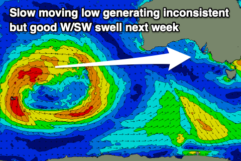
Into the late morning however, some small, inconsistent mid-period W/SW swell is due to start building across the Mid Coast.
The source is a slow moving mid-latitude low pushing through the Indian Ocean, through the Mid Coast's western swell window. A fetch of strong to sub-gale-force W/SW winds will move slowly east over the coming days, breaking down on approach to Western Australia.
This swell will favour the Mid Coast and come in small down South, with it due to build through Tuesday and peak later in the day. The Mid Coast should build to 2ft+ through the afternoon, with slowly easing sets from 2ft on Wednesday, with Middleton only offering 1-2ft surf.
Winds as touched on above will shift from the N/NE to S/SW through the day as the swell arrives Tuesday, with Wednesday seeing E/SE-SE morning winds ahead of sea breezes.
Longer term the outlook remains tricky but not ideal. More on this Friday.