Large swell with average winds for the South Coast

South Australian Surf Forecast by Craig Brokensha (issued Friday October 6th)
Best Days: Mid Coast today, Mid Coast tomorrow working the tides, South Coast Sunday morning, Monday morning, Tuesday morning and Wednesday
Features of the Forecast (tl;dr)
- Large SW groundswell building this afternoon, easing slowly tomorrow with mod-fresh E-E/NE tending S/SE winds
- Easing S/SW groundswell Sun with moderate E/NE tending S/SE winds
- Moderate sized, inconsistent SW groundswell Mon AM with E/NE tending S/SE winds
- Easing swell Tue with E/NE-NE tending S/SE winds
- Smaller Wed with N/NE tending N/NW winds
Recap
Deteriorating conditions across the Mid Coast yesterday with 2-3ft sets on the magnets, a choppy mess into the afternoon with strengthening W winds. Middleton was fun in the morning and a little lumpy with surf to 4ft off Day St and Cliffs, wind affected and smaller into the afternoon.
Today a S'ly change has moved through creating poor conditions down South but with plenty of swell to 4ft and the Mid Coast is slow and to 1-2ft. Early lumps have cleaned up and the surf looks better.
A large new SW groundswell has just hit the Cape du Couedic wave buoy with peak periods pinging at 20s and we should see sets pushing back to a consistent 2ft on the Mid Coast this afternoon with 6-8ft sets across the South Coast. Winds will freshen from the S/SE in the gulf but keep conditions relatively clean.

Slow sets on the Mid Coast this morning
This weekend and next week (Oct 7 - 13)
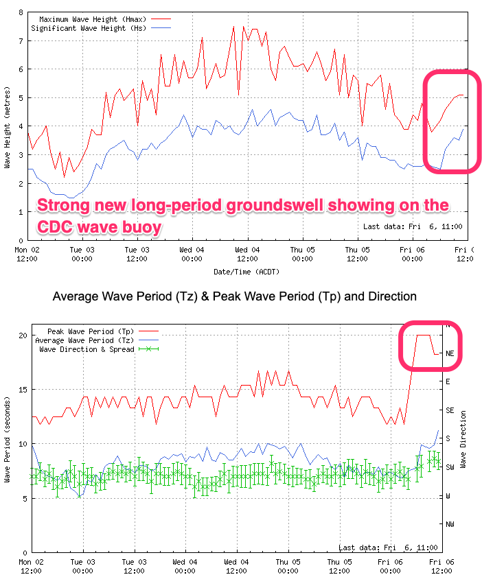
This afternoon's large SW groundswell is due to ease into the weekend while tending more S/SW in direction, with tomorrow morning still due to be large across the South Coast.
Easing 6ft+ sets are due across Middleton with 2ft sets on the Mid Coast, smaller through the day. Winds now look to be a bit better for the South Coast, tending E/NE through the morning but with the large swell, options will be limited.
Sunday will see similar E/NE winds in the morning and smaller, easing sets from 3-4ft, tiny on the Mid Coast.
Into Monday our reinforcing SW groundswell is still on track, generated by a trailing front behind the low linked to today's swell.
A distant fetch of gale to severe-gale W/NW winds around the Heard Island were produced and we should see this generating a fun reinforcing pulse of energy to 3-4ft across Middleton Monday morning, easing into the afternoon. The Mid looks to persist around the 1ft range, ideal for beginners.
A stubborn high sitting west-southwest of us on Monday will continue to bring less favourable E/NE winds in the morning ahead of sea breezes, likely more favourable and E/NE-NE on Tuesday as the swell backs off.

Wednesday will be nice and clean but small and fading from 2ft across Middleton, best on the magnets.
Longer term it looks like a strengthening mid-latitude and polar storm combo will bring W/SW-SW winds later next week and into the weekend along with building levels of lower quality swell. All in all not great so make the most of the coming swell and tricky winds. Have a great weekend!