Tricky period as a strong mid-latitude low develops across us

South Australian Surf Forecast by Craig Brokensha (issued Wednesday September 6th)
Best Days: Today South Coast, dawn tomorrow Mid Coast, South Coast Saturday, Sunday morning, Monday, Tuesday morning
Features of the Forecast (tl;dr)
- Easing surf tomorrow with early variable winds, quickly strengthening from the NW then W/NW, shifting strong to gale-force SW into the PM
- Large, stormy S'ly swell Fri with strong SW winds
- Steadily easing S swell Sat with W/NW-NW winds
- Fun moderate sized S/SE groundswell for Sun AM, easing quickly with N-N/NE tendin fresh E/SE winds
- Moderate sized S/SW groundswell building Mon with N/NW winds, easing Tue with N tending S winds
Recap
A day of contrasts across the Mid Coast yesterday, with terrible conditions at dawn that rapidly improved as expected with winds easing and tending light into the afternoon. This provided super fun 2-3ft waves form the afternoon and evening surf. Today is still 2ft+ but choppy with strengthening northerly winds.
The South Coast was fun and best in protected spots yesterday with 3-4ft of swell, much cleaner today and a great 3ft across Middleton but with the size now on the decline.

Mid Coast last night

South Coast this morning
This week and next (Sep 7 - 15)
Today's strengthening N/NW winds are associated with a rapidly deepening, eastward moving low pushing in from the Bight.
The low is sitting a little too high to be favourable for any major swell production on the Mid Coast, but we do have is an upgrade in the intensity and strength as it moves across and under us tomorrow evening.
Tomorrow looks tricky as the trough moves across us, with dawn variable breezes likely to strengthen quickly from the NW and then W/NW ahead of a strong to gale-force SW change int the afternoon.
Size wise, Middleton looks to be a small 2ft tomorrow morning with 1-2ft sets across the Mid Coast ahead of a building windswell to 2ft+ by dark as the change hits.
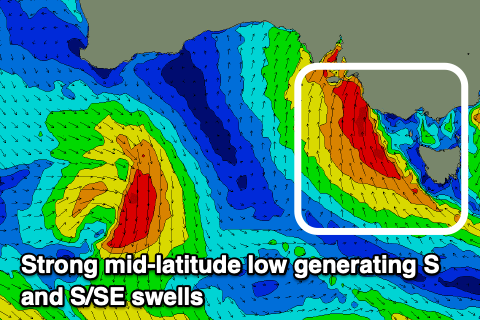
Come Friday we're expected to see gale-force S'ly winds projected up through the South Coast's swell window producing a large stormy S'ly swell to the 6ft+ range but with strong SW winds.
The Mid Coast also looks semi-stormy and to 2-3ft.
The low is due to move off to the east during Friday afternoon and a small trough will swing winds to the W/NW-NW Saturday morning along with a steady drop in localised S'ly swell from 4-5ft. The Mid Coast looks to ease back from a bumpy 1-2ft.
A good pulse of S/SE groundswell is due Sunday morning thanks to gale to severe-gale S/SE winds forming off the Tasmanian West Coast Friday. This should boost the South Coast back to the 3-4ft range ahead of an easing trend during the day along with light N-NNE winds and fresh E/SE sea breezes.
Moving into next week we've got a fun S/SW groundswell due Monday/Tuesday before things go quieter along the South Coast.
A late forming polar frontal progression along the polar shelf, to the south-southwest of Tasmania is expected to produce SW gales through our southern swell window, generating a fun kick in size through Monday, peaking into the afternoon to 3ft+ across Middleton, then easing through the day.
Winds look favourable and out of the N/NW on Monday with a trough possibly bringing a shallow change Tuesday. We'll review this Friday.
Longer term, a strong high that will setup camp in the Tasman Sea and extend west across the continent looks to keep a cap on any major swell developments for the South Coast. Strong frontal activity in the southern Indian Ocean looks to generate some good W/SW groundswell for the Mid Coast later next week onwards but again check back Friday.