Tricky period with flukey winds but lots of west swell for the coming days

South Australian Surf Forecast by Craig Brokensha (issued Monday September 4th)
Best Days: Protected spots South Coast tomorrow, Mid Coast into the afternoon, South Coast Wednesday, Saturday morning South Coast
Features of the Forecast (tl;dr)
- Mod-large W/SW groundswell building later today, peaking tomorrow AM
- Moderate sized, reinforcing mid-period W/SW swell building Tue PM, easing Wed
- Gusty W/NW winds easing down South, fresh W/SW tending light W/NW into the PM on the Mid Coast
- Strengthening N/NE tending N/NW winds Wed with easing surf
- Strong W/NW tending W/SW then SW winds Thu with a junky windswell on the Mid Coast
- Strong S/SW winds Fri with a moderate sized + S'ly windswell
- Easing windswell Sat with N/NE tending SE winds
- Small surf Sun with NE tending gusty E/SE winds
Recap
Friday's swell eased back to the 1-1.5ft range on the Mid Coast Saturday with morning offshores, tiny yesterday with freshening N'ly winds, great on the South Coast all weekend with solid 3-4ft sets across Middleton Saturday, smaller and easing from 2-3ft yesterday.
This morning the swell has bottomed out along with a shift in winds to the west, with a building windswell across the Mid Coast. Some stronger W/SW groundswell is due later, discussed in more detail below.
This week and weekend (Sep 5 - 10)
The first in a series of mid-latitude fronts is moving in from the west, bringing gusty W'ly winds today and a building windswell across the Mid Coast.

A larger, stronger W/SW groundswell is due to arrive later today, peaking tomorrow morning, generated by a strong frontal system that fired up west of the Heard Island region later last week.
A fetch of gale to near severe-gale W/SW winds were projected east, weakening on approach to Western Australia. The remnants of this storm are moving through today, with a moderate to large W/SW groundswell due in its wake.
The Mid Coast should come in at 2-3ft tomorrow with Middleton boosting to 3-5ft though winds look a little dicey. In the wake of today's front, gusty but easing W/SW-SW winds are due tomorrow morning on the Mid Coast, lighter W/NW into the afternoon. The South Coast will be best in protected spots with, gusty W/NW-W in the morning and then lighter into the afternoon.
A secondary front that was due to generate some larger, mid-period W/SW swell for tomorrow afternoon and Wednesday morning now looks weaker, with it passing under Western Australia and moving into the Bight today.
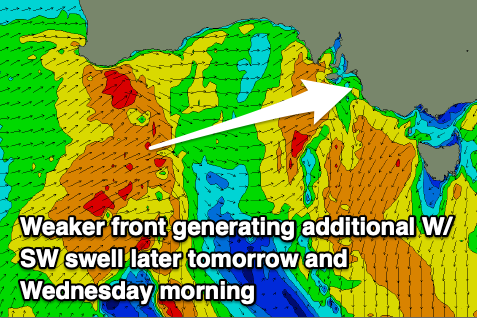
This looks to maintain 2ft to possibly 3ft sets across the Mid Coast Wednesday, easing from 1-2ft on Thursday. Middleton looks to only come in at 3-4ft Wednesday morning, easing though the day and then down from 2ft+ on Thursday.
Winds will be good for the South Cast on Wednesday with strengthening N/NE tending N/NW winds, strong W/NW on Thursday ahead of a W/SW and then SW change late morning and into the afternoon.
This will be as another mid-latitude low moves in from the west, with it not being too favourable for additional swell generation due to it riding a little too far north through the Bight.
What we'll see as it crosses us on Friday though is poor, strong S'ly winds and a localised increase in poor windswell down South.
The Mid Coast will be choppy and wind affected with sets likely to 1-2ft on the favourable parts of the day.
Come the weekend the low is due to move to to the east possibly allowing winds to swing back to the N/NE down South but with a weak, easing S'ly swell from 2-3ft.
Besides a small pulse of mid-period SW swell Sunday with morning offshore winds, the outlook for next week looks slow as the Southern Ocean becomes relatively benign storm wise.
The models diverge regarding a possible fun S/SW swell Monday with the European version, EC being less excited in this regard. A deepening trough to our west could bring persistent E/NE-NE winds but with no decent size. More on this Wednesday.