Improving surf on the weekend

South Australian Surf Forecast by Craig Brokensha (issued Friday June 30th)
Best Days: This morning ahead of a change down South, tomorrow afternoon South Coast, Sunday morning South Coast, Monday South Coast, Tuesday South Coast
Features of the Forecast (tl;dr)
- Building moderate sized + SW swell Fri PM with fresh W/NW tending stronger W/SW winds into the PM
- Slight drop in swell early tomorrow ahead of a reinforcing pulse of moderate sized + S/SW swell into the PM
- Moderate S/SW winds, easing and tending lighter S tomorrow (slim chance of dawn W/NW winds around Victor)
- Easing S/SW swell Sun with N/NE tending E-E/SE winds
- Smaller, easing surf Mon with N/NE tending E/NE winds
- Small, inconsistent SW groundswell early Tue, easing with strengthening N/NW winds (moderate in the AM)
- Moderate sized + mix of W/SW swells for mid-late next week
Recap
Tiny waves across the Mid Coast, lumpy yesterday and bumpy today, while the South Coast has provided plenty of size with moderate levels of mid-period SW-S/SW swell with favourable winds for protected spots. Today is 4ft off the Bay with more size towards Goolwa. Winds will shift W/SW through the afternoon so get in this morning.

Lots of size this morning
This weekend and next week (Jul 1 - 7)
Today we've got a reinforcing pulse of mid-period S/SW-SW swell across the South Coast and it should peak through the day to 4-5ft odd Middleton (looks to be already there).
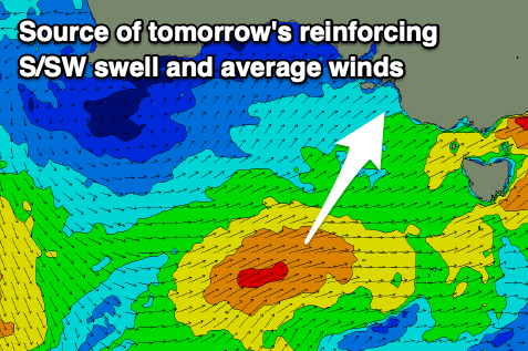
A slight drop in size is expected into tomorrow morning ahead of a final pulse of reinforcing mid-period S/SW energy through the afternoon. This is being generated by a final front on the backside of the progression seen through the week, with wind speeds coming in just below gale-force though acting on top an active sea state.
The morning looks to be mostly in the 4ft range across Middleton, though kicking back to 4-5ft through the day, then easing from 3-4ft Sunday morning. The Mid Coast looks to be in the 1ft range and only for beginners.
Now, winds are tricky thanks to the final front bringing a S/SW change around dawn tomorrow, with easing S'ly winds through the day. This will create improving conditions into the afternoon and the chance of a W/NW wind around Victor looks slim (but not out of the question). The Mid will be clean but tiny as touched on above.
Sunday looks much better for a surf with a N/NE offshore, shifting E-E/SE through the afternoon so try and get in before lunch.
Monday looks great as well with a N/NE tending NE offshore but smaller, easing 2-3ft sets across Middleton, best on the magnets.

Later in the day a new pulse of SW groundswell might be seen, with it due to peak overnight and ease Tuesday.
This funky swell is due to spread out radially from a great fetch of gale to severe-gale NW winds being projected towards the polar shelf this afternoon through early tomorrow, to the south-west of Western Australia.
Lower the expectations but slow sets to 2ft are likely to persist Tuesday morning before easing through the day and with strengthening N/NW winds (moderate in the morning).
The strengthening winds will be associated with the next flurry of mid-latitude frontal activity moving in from the west, starting in the southern Indian Ocean.
Multiple fetches of gale-force winds are forecast to be generated through our western swell window, with the progression moving in under Western Australia Tuesday and then through the Bight Wednesday.
This should bring with it building levels of groundswell and mid-period swell though with poor winds for the Mid Coast, out of the western quadrant. We'll have a closer look at this on Monday though. Have a great weekend!