Large windy west swell for the weekend

South Australian Surf Forecast by Craig Brokensha (issued Wednesday June 21st)
Best Days: This afternoon South Coast, keen surfers Friday afternoon South Coast, Sunday South Coast, Monday morning South Coast, Tuesday South Coast
Features of the Forecast (tl;dr)
- Small to tiny tomorrow with gusty NE tending NW winds
- Small, inconsistent SW swell Fri with strengthening W/NW tending N/NW winds
- NW windswell developing on the Mid Coast Fri, bigger Sat and holding Sun
- Large W'ly groundswell for the Mid Coast Sun (moderate in size down South) with strong N/NW tending NW winds, easing Mon with strong W/NW tending weaker W/SW winds
- Smaller Tue with gusty W/NW winds
Recap
Great surf across the South Coast all day yesterday with a moderate sized pulse of S'ly swell to a consistent 4ft or so under N/NE winds, easing back this morning from 2ft+ off Middleton with clean conditions again.
The Mid Coast offered decent, easing 1-2ft sets yesterday with today coming in tiny.

Great surf yesterday afternoon
This week and weekend (Jun 22 - 25)
The coming few days are tricky with smaller, slower swell pulses due across the South Coast while the Mid Coast sees a building NW windswell Friday and Saturday followed by a large W'ly swell Sunday.
Looking at tomorrow and the current easing trend will continue down South leaving tiny surf ahead of an inconsistent mid-period SW swell Friday. This has been generated by a distant, patchy fetch of winds to the south-west of Western Australia earlier this week and should provide inconsistent 2ft+ sets across Middleton, easing back from 1-2ft on Saturday.
Gusty NE winds will shift NW tomorrow as a mid-latitude low starts edging in from the west, with fresh W/NW tending stronger N/NW winds on Friday providing improving options down South through the day while also kicking up a building NW windswell to 2ft+ or so on the Mid Coast.
Now, the mid-latitude low linked to the strengthening N/NW winds will project a fetch of fetch of strong to gale-force W/SW winds through our western swell window tomorrow, Friday and Saturday while slowly pushing east.
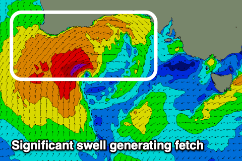
This will generate a large W'ly swell for the weekend, building Saturday and peaking Sunday.
At this stage the Mid Coast looks to offer building stormy waves from the NW Saturday, reaching 3ft+ along with strong N/NW tending NW winds, with the groundswell pushing to 4ft on Sunday. There'll still be 3ft of windswell in the mix, with the two combining to likely offer the odd 5ft peak at times duing Sunday. The metro beaches will also offer plenty of surf.
Strong N/NW tending NW winds will persist Sunday, favouring the South Coast which looks to build very late Saturday but peak Sunday afternoon to 4ft or so across Middleton, a bit bigger towards Goolwa.
Winds will shift less favourable to the W/NW and then W/SW on Monday as the low pushes east, bringing with it a drop in swell across both regions, smaller Tuesday under W/NW winds.
Now, we're looking at some healthy Southern Ocean frontal activity through early-mid next week, bringing some good S/SW groundswell for mid-late week, though winds look a little dicey for the South Coast and out of the SW to S. The Mid Coast should be cleaner but the swell is a bit too south in direction. We'll have a closer look at this on Friday.