Large, windy weekend of west swell

South Australian Surf Forecast by Craig Brokensha (issued Friday June 16th)
Best Days: Today South Coast, South Coast tomorrow, Sunday and Tuesday
Features of the Forecast (tl;dr)
- Building N/NW windswell on the Mid Coast Fri with strong N/NW winds
- Large W/SW groundswell for Sat with strong N/NW-NW tending W/NW winds
- Easing swell Sun with strong NW winds
- Moderate sized mid-period SW swell for Mon with fresh W/SW-SW winds (W/NW early around Victor)
- Easing S/SW swell Tue with moderate N/NW winds, smaller Wed with strengthening N/NE breezes
Recap
A drop in swell but with clean conditions and fun waves across the South Coast yesterday, a little smaller today and back to 1-2ft with clean conditions. The Mid Coast offered a window of OK waves yesterday while today we've got strengthening winds out of the N'th and a building windswell from the N/NW.

Small and clean today down South
This weekend and next week (Jun 17 - 23)
We can expected the N/NW windswell to continue building across the Mid Coast this afternoon but into tomorrow a large W/SW groundswell is due to fill in, generated by a slow moving Southern Ocean gyre that developed to the south-southwest of Western Australia earlier this week.
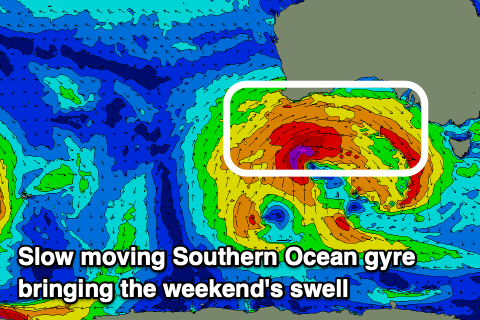
Back to back fetches of gale-force to severe-gale westerly winds have been aimed through our western swell window, with the gyre to to continue east on the weekend while slowly weakening.
This will see large surf across the Mid Coast tomorrow as the groundswell fills in, reaching 3ft+ (4ft at times through the day) while the South Coast should come in around 4-5ft along the Middeton stetch.
Strengthening N/NW tending NW and then W/NW winds tomorrow will favour the South Coast, though into the afternoon with the west swell direction, expect smaller surf in protected spots.
Strong NW winds will then persist on Sunday as the swell starts to ease back in size, dropping from 3ft on the Mid Coast and holding 4ft or so across Middleton.
Into Monday, the South Coast should see some reinforcing mid-period SW swell, generated by the backside of the Southern Ocean gyre, with a fetch of strong SW winds projected up and into us through Sunday.
We should see Middleton holding 4ft with 2-3ft sets on the Mid Coast along with less favourable, gusty W/SW-SW winds. The Victor region should see a morning W/NW breeze, but Tuesday looks the pick with good size, easing levels of mid-period S/SW swell from 3ft+ under all day, moderate N/NW winds.
Longer term a large cold outbreak is expected to push up and across the south-east of the country later next week, bringing some new swell next weekend as it moves east. At this stage it looks like it could all be a bit north to be favourable with windy swell pulses on the cards but check back here Monday for a clearer idea. Have a great weekend!