Large swell to end the week, north-east winds to follow

South Australian Surf Forecast by Craig Brokensha (issued Wednesday May 31st)
Best Days: Today South Coast, later tomorrow South Coast, Friday and Saturday morning South Coast, Sunday, Monday and Tuesday South Coast
Features of the Forecast (tl;dr)
- Large S/SW groundswell building tomorrow with fresh S tending variable E/SE winds
- Large, easing S/SW swell Fri with fresh NE winds
- Further drop in size Sat with mod-fresh N/NE tending E/NE winds
- Moderate sized S/SW groundswell building Sun with fresh NE winds
- Easing swell Mon with lighter NE tending E winds
- Smaller Tue with N/NE tending NE winds
Recap
The Mid Coast has been bumpy and not ideal with average 1-1.5ft waves yesterday, a little cleaner this morning and maintaining the same size.
The South Coast offered much better surf with solid sets still to 4-5ft out of the south yesterday, down to 3ft today. Conditions are great and there are options all over so make the most of it before winds go funky tomorrow.
Check out my review of the autumn just gone and why the South Coast is back in form: Autumn Review: Back In Black

Plenty of size left in the mix this morning
This week and next (Jun 1 - 9)
A strong frontal progression that's currently pushing up and towards us will bring a fresh S'ly change early tomorrow as it clips us, weakening and swinging variable E/SE through the late morning/afternoon. This will create poor but improving conditions especially after lunch.

The front linked to the change will bring a large, new S/SW groundswell, generated by rolling fetches of W/SW tending SW gales through our south-western and then southern swell windows yesterday and today.
Building sets to a strong 6ft are due later tomorrow across Middleton, easing back from a similar size range on Friday morning and then down from 3ft on Saturday morning.
The southerly angle of the swell will limit any major size being seen on the Mid Coast with 1ft waves due for the most part. Conditions will be best on the Mid tomorrow, while an approaching mid-latitude low through the Bight from the west will tip winds NE on Friday, being fresh in nature.
A touch more north is due in the winds on Saturday morning as the swell eases, moderate to fresh from the N/NE but tending E/NE into the afternoon.
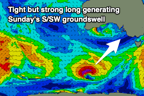
Into Sunday we'll see a new pulse of healthy S/SW groundswell arriving through the morning, generated by a strong, tight polar low. A fetch of severe-gale W/SW winds are due to move through our southern swell window tomorrow and Friday, with the swell building to 4ft by late morning/midday down across Middleton but not impacting the Mid Coast.
Winds look to persist out of the NE and remain fresh thanks to the mid-latitude low stalling west of us, weakening and Monday, bringing lighter NE winds. The swell will ease steadily, dropping back from 2-3ft.
Following this, next week looks slow as the mid-latitude low combined with a blocking high to its south, prevents any major swell generating systems from firing up towards us. Winds look to be favourable for exposed spots with winds out of the north-eastern quadrant along with small background pulses of groundswell. More on this in Friday's update.