Easing surf with favourable winds

South Australian Surf Forecast by Craig Brokensha (issued Monday May 29th)
Best Days: Today South Coast, tomorrow and Wednesday South Coast, Friday and Saturday South Coast, Monday South Coast
Features of the Forecast (tl;dr)
- Easing swell Tue with W/NW-NW winds (NW from late AM to mid-PM), smaller Wed with NW-N/NW winds
- Low point in swell Thu AM with variable tending SE then E/NE winds
- Mod-large S/SW groundswell building late Thu, easing Fri with N/NE-NE winds
- Easing surf Sat with N/NW tending S winds
- Moderate sized S/SW groundswell Sun with E-E/NE winds
- Easing surf Mon with N winds
Recap
Great conditions in protected spots on Saturday with a good 4ft or so of swell, larger on the magnets and poor across the Mid Coast.
Yesterday saw larger surf filling in down South, with an initial SW groundswell for the morning coming in at 4-6ft with workable W/NW winds, though pulsing larger to 8-10ft as the strongest pulse of long-period S/SW swell filled in.
This swell has eased back slightly this morning though conditions are great with easing sets from 6-8ft on the magnets and we should see conditions remaining clean all day.
This week and weekend (May 30 – Jun 4)
The size will continue to ease over the coming days and winds looks favourable with an offshore W/NW-NW breeze that will strengthen from the NW through the late morning and early afternoon, back to the W/NW later.
Middleton should still be in the 4ft+ range tomorrow morning, back further from 3ft on Wednesday. Winds will remain gusty from the NW-N/NW on Wednesday, opening up options across the more exposed beaches with the easing swell while the Mid Coast will back off from 1-1.5ft.
Thursday is a tricky one as we reach a low point in swell and a trough is expected to bring a funky SE tending E/NE wind as a mid-latitude low deepens to our west.
This will see varying conditions that will be generally bumpy, better into Friday with gusty N/NE-NE tending N/NE winds.
Swell wise, a moderate to large S/SW groundswell is expected to build later Thursday, peak overnight and ease through Friday.
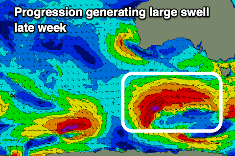
The frontal progression linked to this swell will develop south-southwest of Western Australia today but be patchy, strengthening and becoming more consolidated tomorrow evening and Wednesday, generating a great fetch of gale to severe-gale W/SW winds while projecting north-east towards us.
The swell should build to 4-6ft on dark Thursday with E winds, easing back from 4-5ft+ Friday with those north-east winds. The Mid Coast will unfortunately only be tiny with 1ft sets max.
Saturday morning will be great as the swell continues to ease under a light offshore wind and a trough will bring a shallow SE change.
This will be linked to the mid-latitude low to our west weakening while drifting slowly east and with this we're looking at E'ly winds on Sunday along with a fresh pulse of S/SW groundswell.
A strong but tight polar low should generate a fetch of severe-gale winds and good pulse of size to 3-4ft across Middleton Sunday, easing Monday under great N'ly offshore winds.
Longer term it looks like we'll see a run of W'ly swell as strong frontal systems push up and into Western Australia but we'll have a closer look at this on Wednesday.