Mostly clean down South with tons of swell
South Australian Surf Forecast by Craig Brokensha (issued Monday May 22nd)
Best Days: Both coasts today, South Coast tomorrow, Wednesday and Thursday afternoon, South Coast Saturday, Sunday and Monday ahead of the change
Features of the Forecast (tl;dr)
- Moderate sized + S/SW swell easing tomorrow, with a reinforcing pulse for later in the day, easing Wed
- Mod-fresh N/NW tending NW winds tomorrow, N/NW Wed, strengthening into the PM
- Low point in swell Thu ahead of a new S/SW swell into the PM and building windswell on the Mid Coast
- Strengthening W/NW-W winds ahead of an evening S/SW change
- Moderate sized mix of stormy swells on Fri with strong S/SW-SW winds
- Easing swell Sat with NW tending W/NW winds
- Moderate sized SW swell Sun ahead of a late increase in new S/SW groundswell, easing Mon
- NW winds Sun, fresher NW Mon ahead of a late PM change
Recap
Poor surf across the Mid Coast all weekend, tiny and choppy Saturday, a little better yesterday though not great. The South Coast provided better options Saturday morning with a period of light winds ahead of an onshore change late morning, poor yesterday with a sizey, stormy increase in swell.
Today we've got a mix of mid-period SW swell and stronger S/SW groundswell on the build along with light winds. The Mid Coast is 1-2ft with the South Coast coming in at 4-6ft and winds should hold from the W/NW-SW most of the day, favouring protected spots while being variable on the Mid Coast.
This week and weekend (May 23 - 28)
Tomorrow will be great all day down South with today's increase in S/SW groundswell due to ease slowly through the day, slowed a little later in the afternoon and Wednesday by a moderate sized mid-period S/SW swell.
The reinforcing swell was generated by a trailing front behind the system responsible for yesterday's and today's swell, and size wise, the South Coast should ease back from 4-5ft tomorrow morning, and then 3ft to possibly 4ft Wednesday morning.
The Mid looks to become tiny, easing back from 1-1.5ft.
Winds will be moderate to fresh from the N/NW tending NW tomorrow (N/NE early on the Mid Coast), with N//NW winds holding all day Wednesday, strengthening into the afternoon.

A temporary low point in swell is due on Thursday and an approaching front will see winds shift W/NW and strengthen through the day, tending W'ly late afternoon ahead of a strong evening S/SW change.
A building windswell is due on the Mid Coast through Thursday, reaching a stormy 2-3ft into the afternoon, with some larger mid-period W/SW swell from the earlier stages of the front due to fill in Friday. This should maintain 2-3ft waves on Friday but with those poor winds, easing back Saturday from 2ft to occasionally 3ft.
Down South, a fun new mid-period S/SW swell is due into Thursday afternoon, generated today, south of the country and with the W winds and building sets to 3ft+, Middleton should be OK.
Friday will be stormy and onshore, much, much better Saturday with NW tending W/NW winds and moderate-large sized SW swell to 4-5ft+.

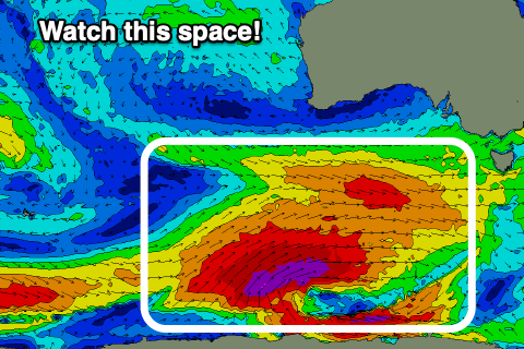
Of greater importance is a much more significant frontal progression forming under the country later week. We're expected to see a broad, elongated fetch of pre-frontal W/NW gale setting up an active sea state for post-frontal severe-gale to storm-force SW winds to project up and over on. This trailing fetch will push up and across Tasmania on the weekend, with a large, long-period S/SW groundswell due to follow.
EC has the system being a touch weaker than GFS but regardless we're looking at strong 6-8ft sets later Sunday and early Monday down South with the Mid Coast coming in 2ft+.
Winds at this stage will be out of the NW on Sunday and NW Monday ahead of late afternoon SW change, but we'll review this size and conditions on Wednesday.


Comments
I enjoy reading your forecasting to show my Groms
Do you write one for Yorke Peninsular also?
No he doesn't Krista - forecaster notes are for mid and south coasts only but if you know what ur looking for you can derive the yorkes forecast from the notes yourself
Thanks Krista, yeah we don't to a Yorkes forecast but you can infer conditions and sizes from the details in here if you're clued in :)