Good period with plenty of options

South Australian Surf Forecast by Craig Brokensha (issued Friday April 14th)
Best Days: Mid Coast later this afternoon, South Coast all day today, protected spots down South tomorrow, Monday and Tuesday both regions, Mid Coast Wednesday morning, both coasts Thursday, South Coast Friday morning
Features of the Forecast (tl;dr)
- Moderate sized W/SW groundswell and mid-period energy Fri with local morning offshore winds, tending N on the Mid and NE down South while freshening (winds easing across both coasts mid-late PM)
- Easing surf Sat with fresh to strong W/NW winds (W/SW-W on the Mid)
- New moderate sized W/SW swell for Sun with gusty, but easing SW winds
- Easing surf Mon with N/NE tending weak NW winds on the Mid, N/NW tending variable down South
- Fun, reinforcing W/SW swell Tue with similar winds to Mon
- Mod-large sized W/SW groundswell building Wed, peaking in the PM, easing Thu
- Gusty S/SW winds Wed (S/SE early on the Mid), light SE tending variable winds Thu
Recap
Yesterday morning was average down South with lingering onshore winds but plenty of swell, improving into the afternoon as winds eased and tending more W/SW. Today is the pick though with great conditions, sunny skies and 3ft of swell across Middleton.
The Mid Coast saw lumpy/bumpy 2ft waves through yesterday morning, best into the afternoon with the incoming tide pulsing to 2-3ft with a more than workable onshore wind. Today northerly winds are up and into the surf early, making choppy conditions with the 2ft of swell. Winds are due to ease into the mid-late afternoon across both regions, providing improving surf on the Mid and keeping the South Coast clean.


Decent size yesterday afternoon on the Mid and clean conditions this morning down South
This weekend and next week (Apr 15 - 21)
Yesterday afternoon's good pulse of W/SW groundswell which is holding this morning, will be followed by a reinforcing pulse this afternoon, easing slowly into tomorrow.
Winds will swing around to the W/SW-W on the Mid, creating choppy conditions while the South Coast should see W/NW winds most of the day and we'll see easing 3ft sets across Middleton, with 2ft surf continuing on the Mid Coast.
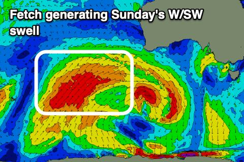
Now, the mid-latitude front moving in tomorrow will bring with it a good, moderate sized pulse of mid-period W/SW swell that's due to build through Sunday, peaking into the afternoon before easing Monday.
A great fetch of strong to gale-force W/SW winds have projected towards Western Australia, weakening while moving under their state today and then onwards through the Bight.
We should see plenty of size across the Mid Coast on Sunday to 2ft+ with Middleton building to 3ft to possibly 4ft. Winds will remain an issue though with strong but easing SW winds due on Sunday, creating poor conditions across both regions, easing into the evening and then tending N/NW down South on Monday morning, with early N/NE winds on the Mid Coast.

Conditions will be bumpy in the gulf but with easing 2ft sets, great across the South Coast with easing 3ft sets. Lighter winds in the gulf through the afternoon should provide fun options after lunch.
The Mid Coast doesn't look to drop below 2ft on the favourable parts of the tide on Tuesday thanks to persistent mid-latitude frontal activity generating reinforcing W/SW swell energy, 2-3ft across Middleton and with similar winds to Monday.
We've got more action due into the middle to end of the week as a strong frontal system pushing up and under Western Australia generates a good, persistent fetch of strong to gale-force W/SW winds through our western swell window. As the front approaches us, it's expected to form a low pressure centre, possibly producing an additional fetch of W/SW gales in our southern swell window.
The W/SW swell energy should fill in Wednesday, peaking through the afternoon, easing Thursday as a good S/SW groundswell fills in.
The Mid Coast should see strong 3ft sets into Wednesday afternoon, with 2-3ft waves Thursday, while the South Coast looks to peak Thursday morning to 4-5ft across Middleton.
Winds look like they'll favour gulf waters on Wednesday/Thursday as S/SE tending S/SW winds move in Wednesday, behind a cold front Tuesday evening, with Thursday seeing SE tending variable winds. The South Coast may see variable winds Thursday morning, but Friday is a greater chance of this.
Longer term we've got plenty more favourable, swell producing frontal activity on the cards for next weekend/week and with favourable winds. A healthy period indeed! Have a great weekend.
Comments
the roaring 40s have finally woken up from their slumber
On ya Craig!
My pleasure.
Nice waves today, down Sth, finally got my quota up.