Poor weekend, improving from Monday but more so Tuesday

South Australian Surf Forecast by Craig Brokensha (issued Friday April 7th)
Best Days: Today South Coast ahead of the change, Tuesday and Thursday South Coast, Friday South Coast (early Mid)
Features of the Forecast (tl;dr)
- Building W windswell on the Mid Coast Fri, easing Sat
- Poor Sat with strong SW winds and a building S/SW windswell
- Building mid-period S/SW swell Sun with strong S/SW winds
- Easing S swell Mon with light-mod E/NE tending S/SE winds
- Inconsistent SW groundswell Tue/Wed/Thu
- Strengthening N/NE winds Tue, easing later
- Fresh W/SW winds Wed
- Moderate N/NE tending variable winds Thu
- Building W/SW groundswell Thu PM, peaking Fri with gusty N/NE winds
- Stronger W/SW groundswell for Fri PM and Sat with W/SW winds likely
Recap
Clean surf yesterday morning but on the small, slow side and to 1-2ft across Middleton ahead of some new swell through the late afternoon/evening with freshening NW winds. The Mid Coast was tiny and bumpy.
This morning the swell is still in the water with 2-3ft sets off Middleton with early W/NW winds that are will shift onshore soon so get out now. The Mid is seeing a poor, building W'ly windswell.

Ahead of the change this AM
This weekend and next week (Apr 8 - 14)
Most of the weekend will unfortunately be a total write-off thanks to strong onshore winds and nowhere to really hide, along with a low quality swell.
This afternoon's strong SW change will persist tomorrow with strong SW winds holding all day as we see a mix of building windswell and mid-period S/SW energy thanks to a strong polar front pushing up behind a mid-latitude low that's currently pushing east across us.
Size wise Middleton looks to build to a stormy 3ft or so tomorrow, better in size and energy Sunday and to 3-5ft but with strong S/SW winds. The Mid Coast will see 1-2ft waves tomorrow morning, fading from 1ft Sunday.
We're now looking at a window of improving conditions on Monday as winds ease and tend E-E/NE for a short period. The swell will still be very raw and lumpy but better than the weekend with easing 3ft to occasionally 4ft sets off Middleton.
Tuesday looks fun as winds tend N/NE and strengthen ahead of a mid-latitude front, easing into the late afternoon as we see a mix of easing S'ly swell and inconsistent, new SW groundswell.
The groundswell has been generated by the initial stages of the front pushing into us this weekend. It'll be inconsistent but to 3ft across Middleton, easing later, while a reinforcing pulse of long-range groundswell should maintain 2-3ft waves on Wednesday.
The Mid Coast won't see any of this energy, though strong W/SW winds moving through Wednesday will kick up a weak, local windswell.
Thursday looks to remain similar in size to Wednesday with background levels of groundswell along with N/NE tending variable winds.
Later in the day a small pulse of inconsistent W/SW groundswell is due, peaking Friday morning ahead of a secondary pulse of W/SW groundswell into the afternoon.

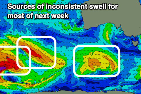
The source of these swells is a strong but patchy progression of frontal systems projecting up towards and under Western Australia from this weekend through next week.
A small, initial low only looks to generate inconsistent 3ft sets down South on Friday morning, with 1ft to possibly 2ft sets on the Mid Coast but with strengthening N/NE winds.
The secondary pulse of groundswell for the late afternoon looks to come in at 4ft across Middleton on the sets Saturday morning with 2ft+ surf on the Mid Coast along with W/SW winds as the swell generating front clips us. We'll have to review this on Monday though as there's a fair bit to get through before then.