Fun, small South Coast tomorrow, onshore until next Tuesday

South Australian Surf Forecast by Craig Brokensha (issued Wednesday April 5th)
Best Days: South Coast tomorrow, South Coast Tuesday ahead of late sea breezes, protected spots next Friday down South and Saturday
Features of the Forecast (tl;dr)
- Fun mid-period S/SW swell building tomorrow, peaking in PM with mod-fresh N/NE tending gusty NW winds, easing later
- Easing swell Fri with strong SW winds moving in around dawn
- Building W windswell on the Mid Coast later Fri, easing Sat
- Poor Sat with strong SW tending S/SW winds and a building S/SW windswell
- Building mid-period S/SW swell Sun with strong S winds
- Easing swell Mon with mod-fresh S/SE winds
- Inconsistent SW groundswell Tue with N/NE tending SE winds mid-PM
- Easing swell Wed with fresh N/NE tending variable winds
- Building W/SW groundswell Thu PM, peaking Fri with NW tending SW winds Thu and W/NW-NW winds Fri
- Stronger W/SW groundswell for Fri PM and Sat
Recap
Great conditions down South through the morning with fun waves to 2ft across Middleton, giving into weak sea breezes. Today the swell is smaller but nice and clean, best on the exposed breaks.
The Mid Coast has been clean but to 0.5ft+ yesterday, flat today but now showing 0.5-1ft on the sets.
This week and next (Apr 6 - 14)
Tomorrow should be another fun day across the South Coast magnets with a small pulse of new mid-period S/SW swell due to build through the day, coming in at 2ft across Middleton in the morning ahead of a peak through the afternoon to an inconsistent 3ft on the sets.

Winds will change through the day with morning N/NE breezes due to shift NW through the day and ease later. So there should be decent options most of the day.
Friday now unfortunately looks average with a mid-latitude low pushing in from the west expected to bring a SW change around dawn that will strengthen through the day.
This will bring a poor quality windswell to the Mid Coast, reaching 1-2ft later, and easing from a similar size Saturday.
The South Coast will see easing levels of S/SW swell, with some weak S/SW windswell on Saturday along with poor, strengthening SW tending S/SW winds.
Unfortunately a polar front pushing up on the backside of the mid-latitude low will maintain poor, gusty S'ly winds across both regions into Sunday along with a building mid-period S'ly swell down South.

Increasing surf to the 4ft range is likely through the afternoon, easing Monday from 3-4ft as winds shift S/SE. The Mid Coast will become cleaner on Monday but there'll be nothing of size to surf.
Winds will finally shift back offshore from the N/NE on Tuesday along with a small, long-range SW groundswell.
This groundswell is being generated by the initial, strongest stages of the polar front pushing up on the weekend, with a fetch of gale to severe-gale W/NW winds due to produce inconsistent 3ft sets across Middleton on Tuesday before easing later and down from 2ft Wednesday.
Sea breezes on Tuesday look to arrive mid-late afternoon, with fresh N/NE tending variable winds Wednesday.
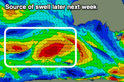
Now as touched on in Monday's notes, we're looking at increasing Southern Ocean storm activity developing in the Heard Island region this weekend, with it forecast to project east-northeast up towards Western Australia through the early to middle stages of next week.
It looks like an initial strong frontal system will generate a moderate sized W/SW groundswell for later Thursday and Friday morning, ahead of a secondary stronger but more northerly positioned low, generating more size into Friday afternoon and Saturday morning.
Onshore W/SW-SW winds will accompany Thursday's building swell, with W/NW winds on Friday, but we'll have a closer look at this and the sizes on Friday. Beyond this there's plenty more frontal activity to follow, but check back here in a couple of days.
Comments
Doh! Looks like the Romans got the Easter dates wrong this year.