Fun week of surf for the South Coast

South Australian Forecast by Craig Brokensha (issued Monday 3rd April)
Best Days: This morning South Coast, tomorrow morning and Wednesday morning South Coast, Thursday South Coast, Friday morning protected spots South Coast for the keen, Monday morning South Coast
Features of the Forecast (tl;dr)
- Slowly easing swell over the coming days with N/NE tending SE winds tomorrow, N/NE tending fresh E winds Wed
- Fun mid-period S/SW swell building Thu, peaking in PM with mod-fresh N/NE tending NW winds
- Easing swell Fri with strong W/NW tending W winds
- Building W windswell on the Mid Coast Fri, easing Sat
- Poor Sat with strong SW winds and a building S/SW windswell
- Easing S/SW windswell Sun with mod-fresh S/SW winds
- Easing swell Mon with variable tending S/SW winds
Recap
The building swell seen through Friday afternoon peaked on Saturday and conditions were lumpy but doable down South, cleaner and fun on the Mid Coast with 1-1.5ft peelers for the bigger boards.
Yesterday provided more organised surf down South with cleaner surf to 4ft through the morning, clean again on the Mid Coast but tiny.
Today conditions are great again on the South Coast with a little less size again, but holding 3ft across Middleton. Surf before midday ahead of sea breezes.

Good peaky waves this AM and still with a bit of size
This week and weekend (Apr 4 - 9)
The coming week looks fun for the South Coast with the weekend’s swell continuing to ease, but with favourable local morning winds and conditions.
Tomorrow will be clean with a N/NE offshore and further drop in swell from mostly 2ft across Middleton, bigger and better on the magnets.
Sea breezes will kick in around midday, with Wednesday due to play out similar but with fresher E’ly winds into the afternoon. Size wise Middleton looks to become smaller and drop to 1-2ft.
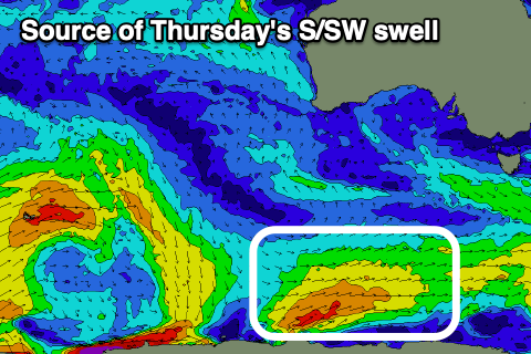
Into the end of the week we’ve got a fun pulse of mid-period S/SW swell due, generated by a relatively weak but favourably positioned polar front developing south of the country today. A fetch of strong SW tending W/SW winds will be projected through our southern swell window, with the mid-period energy expected to build through Thursday and peak into the afternoon.
Middleton should build to 3ft on the sets with smaller 2ft waves in the morning, easing back from 2ft+ on Friday morning. The Mid isn’t due to see much size, with a weak, high-riding mid-latitude low maybe producing 1-2ft of windswell for Friday, easing Saturday.
The mid-latitude low will move east across us on Thursday, bringing moderate to fresh N/NE tending NW winds, favouring the South Coast all day. Stronger W/NW winds are due on Friday as the S/SW swell eases, while also creating that 1-2ft of windswell for the Mid Coast.

The weekend looks poor, with the backside of the low expected to bring strong SW winds on Saturday along with a building S/SW windswell, easing Sunday as winds remain moderate to fresh from the S-S/SW.
There’s a chance winds go variable Monday morning with easing levels of weak S/SW swell in the 2ft to maybe 3ft range down South but we’ll review this Wednesday.
Longer term the Southern Ocean looks to become more active with a larger groundswell possible into the end of next week, but we’ll keep an eye on this and provide updates on Wednesday and Friday.