Windy, building surf, cleanest later week

South Australian Surf Forecast by Craig Brokensha (issued Monday March 6th)
Best Days: Protected spots South Coast tomorrow, Thursday morning both regions, Friday and Saturday mornings South Coast
Features of the Forecast (tl;dr)
- Moderate sized mid-period W/SW-SW swell for tomorrow with gusty W/NW-W winds
- Large mid-period S/SW swell Wed with gusty W/SW winds, easing and tending SW, then freshening again into the PM
- Easing S/SW swell Thu, with a reinforing S'ly swell for mid-late AM
- Light W/NW tending S/SW winds Thu
- Easing surf Fri with light N/NE tending SE winds
- Smaller Sat with N/NE tending SE winds
Recap
Lumpy but improving waves across the South Coast Saturday morning before sea breezes kicked in, best yesterday morning with clean, 2-3ft sets before winds stengthened from the W/NW. The Mid Coast was tiny all weekend.
This week and weekend (Mar 7 - 12)
The first in a series of deepening lows and fronts moved through last night, with this initial one being a bit further south in latitude compared to forecast on Friday, resulting in less size across the Mid Coast.

We've got plenty more action to come, though the South Coast will perform the best with the local winds as a slow moving Southern Ocean gyre sets up camp across Tasmania. This will project a series of strengthening storms up and into us, with a close-range low today, projecting strong to gale-force but weakening W/SW-SW winds to our south-west.
A moderate sized mid-period swell is due from this low tomorrow, coming in around 4ft+ across Middleton and winds look to be gusty out of the W/NW- most of the day, favouring protected spots down South. The Mid will be choppy and messy, coming in around 2ft to occasionally 3ft.
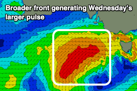
A slightly stronger and broader polar front will follow the low, projecting up out of the south-southwest during this evening and tomorrow, producing a larger mid-period S/SW swell for Wednesday that will provide 6ft surf across Middleton but with gusty, easing W/SW tending SW winds. The Mid Coast will start around the same size but also remain choppy and poor.
The easing trend in swell will be slowed by one final front generating a fetch of strong to gale-force S'ly winds up through our southern swell window tomorrow evening and early Wednesday, producing a reinforcing S'ly swell for Thursday mid-late morning.
Middleton should still be 4-6ft and with a lighter period of W/NW winds around Victor early before shifting more SW-S/SW through the day, with the Mid Coast dropping from 2ft on the sets with a possible early light S/SE breeze.
Smaller, easing surf from 3ft+ should be seen Friday with a light N/NE offshore ahead of SE sea breezes, with the swell bottoming out on Saturday under a N/NE offshore. Longer term the outlook goes a little quiet so make the most of the coming swell and local favourable winds.