A couple more options open up

South Australian Surf Forecast by Craig Brokensha (issued Wednesday January 25th)
Best Days: Friday morning South Coast and for the keen on the Mid Coast later tomorrow and Friday morning, Mid Coast Monday, Mid Coast for the keen Tuesday and Wednesday
Features of the Forecast (tl;dr)
- Inconsistent W/SW groundswell building today with variable offshore winds ahead of a S/SE sea breeze late AM and then a S/SW change into the PM
- Moderate sized mid-period SW swell building Thu PM, easing Fri
- Mod-fresh S/SE winds on Thu, NE tending E/SE winds on Fri
- Easing surf Sat with pre-dawn N/NE winds, shifting W at dawn, then W/SW and SW
- Weak W/SW swell building Sun with S/SE winds
- Better mid-period W/SW swell Mon with SE tending SW winds, S/SE later
- Moderate sized mid-period SW swell for Tue AM, with a stronger groundswell into the PM with gusty S/SE winds
- Easing surf Wed with S/SE winds
Recap
Lighter winds offered workable waves for the keen yesterday down South while today conditions are cleaner with a small, inconsistent swell to 1-2ft. Winds have since freshened with a trough moving in along with some better 2ft+ sets, though it'll get bumpier and chopier.

Lines of new swell with a freshening onshore wind late this AM
This week and weekend (Jan 21 - 27)
Today's groundswell should peak into this afternoon across the South Coast with 2-3ft sets off Middleton but with the freshening onshore wind. The Mid may see inconsistent 1ft sets max with winds improving into the evening.
Some better mid-period SW swell energy is due to build tomorrow afternoon and hold Friday morning, generated by weak fetches of W/SW to SW winds moving through our swell window the last couple of days. An initial fetch of W/SW winds south of WA earlier week is now being replaced by a slightly higher riding fetch of W/SW winds moving through our south-western swell window.
We should see Middleton build to 3ft on the sets into Thursday afternoon, easing from a similar size Friday morning with 1-1.5ft sets on the Mid Coast.

Winds tomorrow will favour the Mid with a moderate to fresh S/SE breeze, with Friday seeing winds tend NE down South, opening up plenty of options from Goolwa to Parsons.
Come Saturday morning we'll be looking at smaller, fading 2ft sets across Middleton, tiny on the Mid Coast but with a W/SW change moving in shortly after dawn, swinging S/SW through the day.
With a small dawn window of clean conditions it's unfortunately not worth chasing.
Saturday's change is linked to a weak trough clipping the state with no significant swell due in its wake, though the Mid Coast should see 1ft+ waves into the afternoon for beginners, with better mid-period energy to 1-2ft expected on Monday with SE tending SW winds. This swell will be generated by the weak fetch shown top left.
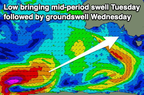
Moving into early to mid next week, a good pulse of mid-period SW swell is due later Monday/Tuesday ahead of a stronger SW groundswell Tuesday afternoon
This swell will be generated by a strong polar low forming around the Heard Island region tomorrow afternoon.
A fetch of severe-gale to storm-force W/SW winds are forecast to be projected east-northeast through our south-western swell window (generating the groundswell), while just ahead of the low, a pre-frontal fetch of strong W'ly winds will be linked to mid-period energy on Tuesday.
Surf to 3ft is due across Middleton Tuesday with 1ft sets on the Mid Coast, with the groundswell kicking into the afternoon to 4-5ft and 1.5ft respectively.
Winds will unfortunately be poor for the South Coast and gusty from the S/SE-S but we'll look at this closer on Friday.
Comments
what's the water quality like down south?
Brown frothy, dead fishy and smelly