Strong swells with tricky winds

South Australian Surf Forecast by Craig Brokensha (issued Monday November 28th)
Best Days: Tomorrow morning both coasts, Wednesday morning South Coast for the keen and experienced, Mid Coast Wednesday morning, Thursday afternoon Mid Coast, Friday morning South Coast, Saturday morning South Coast
Features of the Forecast (tl;dr)
- Moderate sized mid-period S/SW swell tomorrow with light W/NW tending S/SW winds late AM, S/SE-SE tending W/SW on the Mid
- Moderate-large S/SW groundswell Wed AM, easing with moderate S/SE winds, freshening
- Large SW groundswell building Thu PM with mod-fresh E/SE tending stronger S/SE winds
- Easing SW groundswell Fri with moderate E/NE-NE tending S/SE winds
- Easing surf Sat with N/NE tending weak S/SE winds
- Small new swell Sun with N tending SW winds
Recap
A small, slow start to the weekend on the South Coast but the afternoon offered a bit more size as a small S/SW swell filled in. Yesterday was average with the swell dropping a touch along with an onshore breeze.
The Mid Coast was bumpy and flat Saturday, tiny yesterday.
Today we've got a mix of new SW and S/SW swells with 3-4ft waves off Middleton with early W winds which are now onshore. The Mid Coast has also increased slightly in size with sets to 1ft+ but with poor conditions.
This week and weekend (Nov 29 – Dec 4)
 We've got a ton of swell due this week across the state, with an upgrade in the energy due Thursday/Friday. The main issue will be the local winds, not ideal for the South Coast while the swell will only be on the small side across the Mid Coast (which looks to become cleaner).
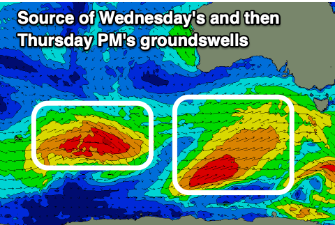
Looking at tomorrow, and our mix of SW and S/SW energy seen today is due to be replaced by some reinforcing mid-period S/SW swell ahead of a stronger groundswell on Wednesday.
These swells are being generated by a drawn out frontal system that's south of us, with the strongest winds within the fetch being generated at its tail.
We'll see mid-period energy from the head of the frontal system moving in tomorrow, keeping wave heights up around 3-4ft across Middleton with 1ft to occasionally 2ft sets due on the Mid Coast.
 The groundswell is due to arrive into Wednesday morning, with stronger 4-6ft sets due across Middleton and deepwater reefs, 1-2ft on the Mid Coast.
Locally winds will deteriorate in the wake of the frontal progression and a trough moving in tomorrow, but we should see a period of light W/NW winds at dawn tomorrow (S/SE-SE on the Mid Coast) before shifting S/SW and W/SW respectively across both coasts late morning.
Unfortunately Wednesday will see S/SE winds (only light to moderate) across the South Coast, creating workable conditions with clean morning conditions on the Mid Coast.
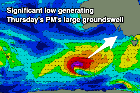
Moving into the end of the week, we've got a large, long-period SW groundswell due to arrive Thursday morning, peaking into the afternoon. This will be generated by a significant low that's now forecast to form on the backside of all the current activity, generating a fetch of severe-gale to storm-force W'ly winds through our south-western swell window.
The size from this low should push to 6ft+ across Middleton and other deepwater reefs, while the Mid Coast should continue around an inconsistent 1-2ft on the favourable parts of the tide.
Winds will improve slowly across the South Coast into the end of the week as a high moves under us, but Thursday will remain average with a moderate to fresh E/SE morning breeze, stronger S/SE into the afternoon.
Friday will be tricky with solid, steadily easing 4-5ft sets across the South Coast and a morning E/NE-NE breeze, much better Saturday with easing 2ft+ sets and a N/NE offshore ahead of relatively weak S/SE sea breezes.
Longer term it looks like we'll return to normal summer programming with a trough moving in Sunday followed by a strong high, and strong S/SE winds. This will be along with no decent swell so make the most of the coming swells, even if winds are dicey.