Poor week for the South Coast

South Australian Surf Forecast by Craig Brokensha (issued Monday September 21st)
Best Days: South Coast Saturday morning and more so Sunday morning
Features of the Forecast (tl;dr)
- Moderate sized SW groundswell building this afternoon, holding tomorrow AM before easing, smaller Wed
- Strong S/SW winds tomorrow, similar Wed AM before easing and tending more S
- Small-mod mid-period SW swell buiding Thu PM with light E/SE tending S/SE winds
- Easing mid-period SW swell Fri with moderate S/SE winds
- Easing surf Sat with E/NE-NE tending SE winds
- Late increase in SW groundswell Sat, peaking Sun with N/NE tending SE winds
Recap
A continuation of good, clean 2ft+ surf across the Mid Coast on Saturday with the surf fading back to 1-1.5ft yesterday. The South Coast was bumpy and average on Saturday with E'ly breezes, much better on Sunday but smaller and back to the 2-3ft range. The magnets were the pick and chunky, with this morning coming in a little smaller again.
A new W/SW groundswell due this afternoon is now on the build but conditions are average across both regions under a gusty SW breeze.

Great waves Saturday AM
This week and next (Sep 27 - Oct 2)
This afternoon's building W/SW groundswell which is showing strongly on the Cape du Couedic wave buoy should see sets reaching 3-4ft across Middleton by dark with developing 2ft sets on the Mid Coast, easing from a similar size tomorrow morning but with poor winds.
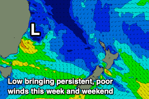 The trough linked to today's change will feed into a broad, inland low to our east, then forming into a strong low in the Tasman Sea. This will create issues for the South Coast all week while spoiling the Mid Coast when the swell is biggest.
A gusty, strong S/SW breeze is due most of tomorrow, holding S and easing back a touch in strength through the afternoon on Wednesday.
On Thursday we may see a variable E/SE breeze down South, with clean conditions on the Mid Coast, but swell wise we'll be in between pulses with background energy due to provide 1ft sets on the Mid Coast and 2-3ft surf down South.
Into the afternoon some new mid-period SW swell is due to arrive, generated by a relatively weak but healthy low that's currently south-west of Western Australia.
Size wise, the Mid Coast is due to remain tiny with 1ft+ sets into Thursday afternoon and Friday morning, while Middleton should see stronger 3ft waves. Moderate S/SE breezes will continue to create average conditions down South on Friday, with a slow improvement expected on the weekend as winds tend E/NE-NE on Saturday morning and more N/NE on Sunday.
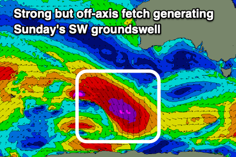 Size wise, Saturday will see easing surf from Friday, backing off from 2ft across Middleton while on Sunday we've got a tricky but fun source of new swell.
This will be produced by a strong but slightly poorly aligned fetch of gale to severe-gale NW winds projecting south-east towards the polar shelf mid-late week. Due to radial spread we should see some fun waves showing across the region Sunday morning with sets to 3ft due across Middleton with that favourable morning breeze.
Moving into next week we've got troughy weather and more mid-latitude storms on the cards along with a possible good SW groundswell, but more on this Wednesday.