Windy and solid, cleaner from Friday

South Australian Surf Forecast by Craig Brokensha (issued Monday August 22nd)
Best Days: Keen surfers early Wednesday protected spots down South, Mid Coast Thursday morning, Friday through Sunday South Coast
Features of the Forecast (tl;dr)
- Moderate + sized mix of mid-period SW swell and groundswell tomorrow with strong S/SW tending SW winds
- Moderate sized + mid-period SW swell Wed with gusty W/SW winds (W/NW for a period around Victor)
- Moderate sized, reinforcing SW swell Thu and Fri with S/SE tending S/SW winds on the Mid, S/SW down South
- Light NE tending E/SE winds on Fri
- Easing S/SW swell Sat with N/NE tending variable winds, smaller Sun with mod-fresh N/NW winds
- Moderate sized, long-period W/SW groundswell for Mon PM with S/SW winds
Recap
Fun waves across the Mid Coast all weekend as conditions improved, initially bumpy on Saturday but cleaning up through the day as winds became light and then variable for the late. The South Coast wasn't great but workable with plenty of swell and an easing onshore wind.
Sunday offered cleaner conditions and sets across all regions, holding 2ft across the Mid Coast with great surf down South as a reinforcing W/SW swell kept waves around 2-3ft across Middleton, easing through the day.
This morning we've reached a low point in swell with clean conditions on the South Coast and tiny, choppy waves on the Mid Coast. A strong SW change is due into this afternoon which will spoil tomorrow's new mix of swells. More on this below.
This week and weekend (Aug 23 - 28)
 From tomorrow onwards we've got plenty of swell inbound, with this afternoon's change linked to the first of a progression of cold fronts pushing up towards us through the Southern Ocean.
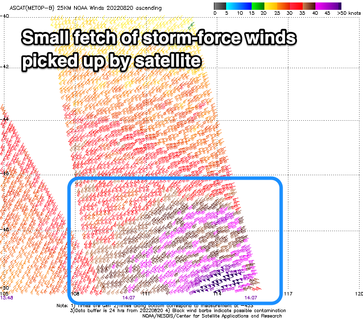
A good pulse of SW groundswell is due to peak tomorrow, generated by an initial polar low that was moving through our swell window last week, though strongest through Friday before weakening on the weekend as moving east and expanding.
The core winds speeds in this fetch were actually fairly impressive and reached storm-force at its core, a little stronger than the models were forecasting.
This will result in a mix of mid-period and groundswell energy tomorrow, peaking through the day to 4ft+ across Middleton with 2ft sets on the Mid Coast, with those stronger winds generating 5ft bombs across Middleton. Unfortunately as touched on in the recap, this afternoon's change will leave strong S/SW winds into tomorrow, shifting back to the SW through the day.
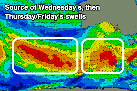
Moving into Wednesday winds should tend more W/SW and be fresh in strength, creating poor conditions on the Mid Coast along with a period of W/NW winds due early around Victor. Swell wise, a slightly bigger mid-period S/SW swell is due on Wednesday, generated by a polar fetch of strong to gale-force SW winds projecting north-east today, weakening tomorrow.
 Stronger surf to 4-5ft is due across Middleton while the Mid Coast should see sets to 2ft though with poor conditions.
The swell should drop a touch into Thursday but a reinforcing mid-period SW swell generated by a great fetch of strong to gale-force W/NW tending W winds swinging in under the country will steady wave heights through the day, holding Friday. Sets to 4ft are due to hold across the Middleton stretch while the Mid Coast will start easing back from 1-2ft.
The South Coast will see winds go back to the S/SW as another cold front clips us. There might be a chance for a dawn W/NW breeze again but we'll confirm this on Wednesday. The Mid should be cleaner with early S/SE winds and weak sea breezes.
From Friday onwards, the South Coast looks cleaner as the frontal activity starts to settle and a high moves in, bringing a NE offshore Friday morning and weak E/SE sea breezes.
 Easing mid-period S/SW energy is due through the weekend, dropping back from 3ft+ across Middleton on Saturday with N/NE tending variable winds, smaller Sunday and easing from 2-3ft and with moderate to fresh N/NW winds. A great weekend of winter surf!
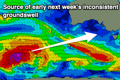
Longer term, a moderate sized, long-period W/SW groundswell is due Monday afternoon across the state, generated by a very strong low developing south of the Heard Island region mid-late week. It looks to generate 4-5ft sets across Middleton with 1-2ft sets on the Mid Coast and a trough looks to bring a S/SW-S change, though we'll have a closer look at this Wednesday.