Windy, sizey surf developing on the Mid Coast

South Australian Surf Forecast by Craig Brokensha (issued Wednesday August 3rd)
Best Days: Keen surfers South Coast Friday, early Saturday South Coast, Sunday South Coast and Mid Coast in the AM, South Coast Monday afternoon and Tuesday
Features of the Forecast (tl;dr)
- Strengthening N/NW winds and a building NW windswell on the Mid Coast tomorrow
- Building W groundswell tomorrow PM, peaking Fri with fresh W/NW winds, strengthening
- Easing W swell on the weekend with mod-fresh early W/NW winds, shifting gusty W/SW mid-late morning
- Moderate sized mid-period S swell building Sat, easing Sun with light W/NW tending SW winds (possibly variable on the Mid early)
- Inconsistent, small W/SW groundswell building Mon with N/NW winds
- Slightly better mid-period W/SW swell for Tue PM with strong N/NE tending N/NW winds
Recap
Fun waves across both coasts yesterday morning with clean conditions and 2ft surf across Middleton, 2ft on the Mid Coast as well with cross-offshore winds and workable waves. The surf deteriorated into the afternoon across both coasts with strengthening N/NW winds on the Mid and easing surf down South.
Today the surf is poor with tiny, windy waves down South and choppy conditions across the Mid Coast along with 2ft of W and NW swells.

Bumpy surf yesterday AM
This week and weekend (Aug 4 - 7)
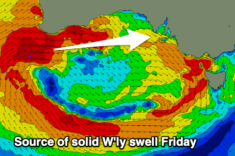
The current run of NW winds and overcast weather is linked to a broad low pressure system that's currently moving in from the west across Western Australia, with multiple embedded cold fronts rotating clockwise around it. These fronts are then tracking south-east on approach to us bringing with it cloudy weather and passing showers.
Swell from this setup is tricky and not ideal for the South Coast, with it being very west in nature and blocked by Kangaroo Island. The Mid Coast will see plenty of size but conditions will be average to poor owing to the persistent strong NW winds.
 Looking at tomorrow and strengthening N/NW winds will create building levels of N/NW windswell on the Mid Coast, likely to 2-3ft into the afternoon while the South Coast will be clean, windy but tiny.
Some new W'ly swell should build on the Mid Coast but it'll be near impossible to distinguish while Friday should see the best pulse coming in at 3ft or so. Winds are due to ease into Friday morning but still be fresh out of the W/NW, strengthening into the afternoon with the next approaching front.
Size wise on the South Coast Friday, some small W/SW swell should refract in past Kangaroo Island with 2-3ft sets due from Middleton to Goolwa. With the wind though, protected spots will be cleanest but small to tiny. A tricky one.
Our better pulse of S/SW swell for the weekend down South is on track, with a funky but healthy fetch of strong to gale-force S/SE winds due to be aimed mostly towards Western Australia but move more into our swell window while weakening Friday.
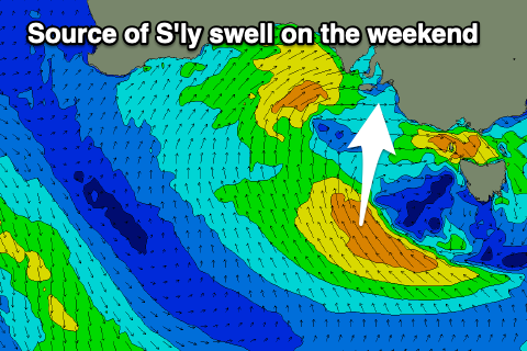 A moderate sized mid-period S/SW swell is due from this source on Saturday, building towards a peak into the afternoon with sets to 3-4ft across Middleton. The Mid Coast will see easing surf back from 2-3ft and winds will be a little dicey for both coasts, W/NW early down South but strengthening from the W/SW through the day and then W/SW all day on the Mid, freshening.
Lighter winds are expected into Sunday and possibly variable early on the Mid Coast with easing 1-2ft waves, fun down South with a light W/NW breeze and easing 3ft+ sets out of the south.
Winds should swing back to the N'th next week with some small, inconsistent new W/SW swell energy Monday afternoon through Wednesday.
The source of W/SW groundswell and reinforcing mid-period energy will be a polar low forming around the Heard Island region today.
An initial brief burst of W'ly gales are due to be followed by strong W/SW winds. The gales will generate a groundswell that will arrive Monday and likely build to a slow 2ft across Middleton (1ft Mid Coast), with the strong winds generating a slightly better mid-period swell for Tuesday afternoon to 2-3ft across Middleton.
Longer term a significant mid-latitude low may fire up under Western Australia during next week generating a large W/SW groundswell for late next week but more on this Friday.
Comments
Can you please tell me if the forecast wind you have in the notes for Sunday, as WNW whereas in the graph & charts & windy com has it as sw all day, is a typo or anomaly? Cheers
Yeah winds are light so local overnight cooling and topographic effects should swing it W/NW.
Agree Barney but Seabreeze shows around 4 knots so its light whichever way it blows