Coupla fun days ahead, then stormy haunts to get a thorough workout

South Australian Surf Forecast by Ben Matson (issued Wednesday 27th July)
Features of the Forecast (tl;dr)
- Light variable winds Thurs (gen W tending S), building swells across both coasts... AM looks fun at Victor, PM on the Mid
- E/NE tending NE winds Fri with plenty of fun surf both coasts
- Small windy weekend down south
- Extended onshore patern next week favouring the Mid Coast and metro beaches
Recap
The Mid picked up 2ft to almost 2-3ft sets on Tuesday, easing to 1-2ft today with generally light to moderate onshore (W’ly) tending cross shore (N’ly) winds making for wobbly conditions. Victor delivered more size on Tuesday with 3-4ft sets at Middleton under a fresh W’ly tending SW flow, easing to 2-3ft today as winds veered NW.
This week (Jul 28 - 29)
We’ve got some new swell inbound over the next few days, and conditions are looking pretty good too.
This energy is sourced from a strong frontal progression south of the continent over the last few days that lined up reasonably well inside the Mid’s swell window, so we should see an increase to 2ft+ through Thursday afternoon (smaller earlier), holding through Friday at a similar size. Expect long waits for the bigger sets.
Even better, local winds are looking favourable with a light variable flow on Thursday - perhaps a light W’ly early, tending S’ly later as a weak front slips south of the state - before veering E/NE on Friday as a high moves in from the west.
Victor should also do well over the coming days, with surf size slowly building to 3-4ft at Middleton throughout Thursday, holding into Friday before starting to ease into the afternoon.
The early session on Thursday will be your best down south as the afternoon will see the southerly ruffle things up, and Friday will require a focus towards locations that can handle a touch of east in the wind direction. But there'll be plenty of options.
This weekend (July 30 - 31)
Looks like we can hone in to the weekend with a little more specificity than Monday's notes - there’s no new swell inbound, apart from some local N’ly windswell in the gulf (ideal for kiteboarders, that’s about it).
Friday’s swell will ease steadily through Saturday and a series of approaching fronts will strengthen N’ly winds to gale force at times, so it’ll be small and windy down south - early 2ft+ sets at Middleton down to 1ft+ by the afternoon and likely even smaller on Sunday.
The Mid Coast won’t see any new groundswell until overnight Sunday, so expect small blustery waves at best, initially some minor leftover groundswell Saturday and then just windswell on Sunday.
Next week (Aug 1 onwards)
Although there is still some model divergence for the long term outlook, the broadscale patterns are looking like delivering a classic wintry pattern ahead with back-to-back fronts marching through the Bight, resulting in plenty of wind and swell for the gulf.
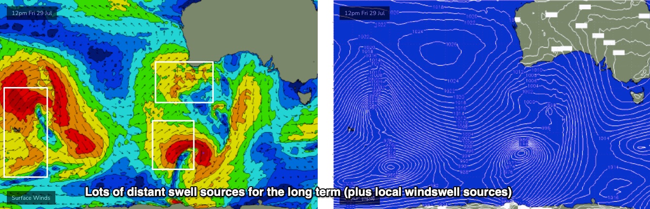
Sunday night will see the first front arrive, delivering gusty onshore and a mix of swells from several source - local and distant. Had the local synoptics been more favourable, I’d go into more detail about the origin of these swells (see some of 'em below), but as you probably won’t be surfing anywhere but the usual stormy haunts, it’s simply not worth the time.
Essentially, this is shaping up to be an extended pattern of small windy waves at Victor - the W’ly swell direction will be heavily attenuated by Kangaroo Island, resulting in plenty of NW days favouring Waits/Parsons (maybe Mon, most likely Tues/Wed/Thurs).
Otherwise, it’s looking like a bumpy all-week affair on the Mid, with select days for the metro beaches when the winds get above 25kts. I’ll fine tune the specifics in Friday’s outlook on which days will see the most size. But you’re gonna need boots, gloves and a hood to combat the windchill and embedded hailstones.