Poor weekend, better options next week

South Australian Surf Forecast by Craig Brokensha (issued Friday June 17th)
Best Days: South Coast Monday afternoon and Tuesday morning, both regions Wednesday
Features of the Forecast (tl;dr)
- Tiny W swell for Fri PM, easing Sat PM with mod-fresh N/NE winds Sat
- Tiny Sun with strong N/NE winds
- Building, moderate sized mid-period W swell Mon, holding Tue, easing Wed
- Gusty N tending NW winds Mon (N/NE early on the Mid), fresh W//NW tending W/SW Tue
- Moderate NW winds down South Wed, NE tending NW on the Mid Coast
- Moderate sized W/SW groundswell for Friday-Sun next week
Recap
Workable and improving surf across the Mid Coast yesterday with early light onshore winds tending variable along with 1-2ft sets. The South Coast was cleaner but small and weak, best in semi-protected spots.
Today the Mid is clean but back to 1ft, with nice conditions also down South and peaky 1-2ft sets.
This weekend and next week (Jun 18 – 24)
 The weekend isn't too exciting regarding surf prospects with a small to tiny, inconsistent W/SW swell due to move in this afternoon and ease through tomorrow. The Middleton stretch may see inconsistent 1-2ft sets but it'll be mostly 1-1.5ft and easing through the day. The Mid Coast looks to hold around 1ft.
Looking at the winds and a moderate to fresh N/NE breeze will favour the South Coast with the Mid becoming wind affected, more so Sunday as wind strengthen further from a similar direction owing to an approaching mid-latitude frontal system.
With the tiny swell down South though there'll be nothing to recommend.
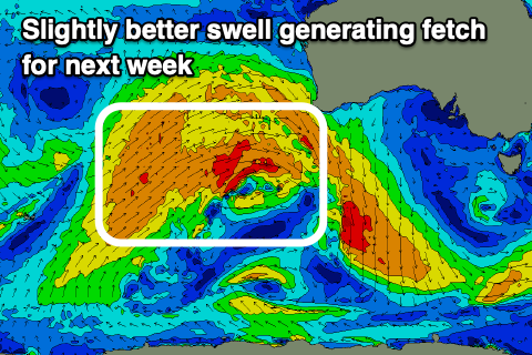
Looking at the outlook for next week and we've got a bit of an upgrade of the mid-period W/SW swell due Monday through Wednesday with the broad, elongated frontal progression that's currently pushing up and into Western Australia.
A good fetch of strong to sub-gale-force W/SW-W winds are being aimed through our western swell and we'll see a moderate sized swell building through Monday and reaching 2ft+ across most breaks, holding Tuesday and then easing from 2ft Wednesday.
 Owing to the westerly swell direction the South Coast will miss out on a bit of size but should come in around 2-3ft across Middleton (inconsistent).
Winds will favour the South Coast with gusty N tending NW winds on Monday (N/NE early on the Mid Coast) with fresh W/NW tending W/SW breezes Tuesday. Lighter NW winds might be seen on Wednesday favouring the South Coast again.
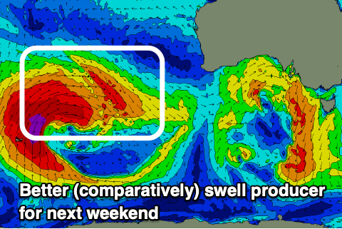
A temporary low point in swell is expected on Thursday but into Friday and the weekend, we're looking at the arrival of a moderate sized W/SW groundswell. This will be generated through the southern Indian Ocean and looks to be prolonged but with winds out of the western quadrant. More on this Monday, have a great weekend!
Comments
Wow, today is showing a bit better than expected across Middleton and further west, and the source, a long-range SE groundswell from under New Zealand.
You can see it on the wave spectral analysis..
The background W/SW-SW energy is so weak but the SE lines strong but inconsistent. Incredible!
Well there’s a first for everything (at least observed anyway)
Very interesting
Hit Gippsland pretty solid too
Looks like it may have even taken the buoy outta action for a fews hours
Spewing I missed this one. Always like to get on the road & clock up some miles to see what something rare like this can bring
that is very unusual indeed Craig. The cdc buoy is showing some combined swell size, but here on the ep its small, just the west swell, 2ft at my local.