Large swell inbound with tricky winds

South Australian Surf Forecast by Craig Brokensha (issued Monday May 2nd)
Best Days: South Coast today and tomorrow, Mid Coast early tomorrow, Thursday Mid Coast, Friday morning Mid Coast, Saturday morning South Coast, Sunday South Coast
Features of the Forecast (tl;dr)
- Mix of inconsistent W/SW and SW groundswell tomorrow AM, easing with mod-fresh N/NE tending stronger N/NW then NW winds on the Mid, N tending fresher NW winds down South
- Large mix of building mid-period W/SW swell Wed with a late pulse of groundswell, peaking Thu AM
- Strong W/SW-SW winds Wed (possibly W/NW dawn Victor)
- Strong S/SW winds Thu (likely S/SE early on the Mid)
- Moderate S/SW winds Fri (S/SE early on the Mid) with fading surf
- Smaller Sat with light, local offshore winds and afternoon sea breezes
- Fun S/SW swell Sun with NE tending variable winds
Recap
New levels of W/SW swell arrived into Friday afternoon with the surf building further Saturday but with lots of bumps and chops owing to a fresh onshore wind, easing into the afternoon allowing the 3ft sets to clean up. Yesterday was better with lighter winds and fun, bumpy 2-3ft sets on the Mid.
The South Coast saw a bit of size kicking in Saturday, cleanest Sunday with offshore winds and strong sets.
Today both coasts are back a bit in size to 1-2ft on the Mid Coast swell magnets though still 3ft off Middleton.

The mythical Bay barrel
This week and weekend (May 3 - 8)
Make the most of the current clean conditions down South (including tomorrow) as we'll see onshore winds kick in from Wednesday, spoiling a large W/SW groundswell due into the afternoon/Thursday.
Looking at the next 24 hours and a new pulse of W/SW and SW groundswell are due later today, easing through tomorrow.
The SW energy was generated by a strong, small polar low that formed south-southwest of Western Australia, with the W/SW energy produced by a front moving in under Western Australia, generating W/NW gales.
The W/SW pulse should maintain 2ft sets across the Mid Coast tomorrow, with Middleton continuing at 3-4ft with the SW groundswell.
Conditions will be best early on the Mid though a touch bumpy with a moderate to fresh N/NE tending stronger N/NW breeze, NW into the late afternoon. The South Coast should be clean all day, best across the exposed breaks in the morning before winds shift more NW.
We'll see a W/SW-SW change moving through Wednesday as a strong frontal progression pushes up and across the state, linked to our larger mix of swells into Wednesday afternoon and Thursday morning. There might be a dawn W/NW'ly around Victor but it's not worth driving from Adelaide for.
Swell wise, a mix of mid-period W/SW energy is due to be in the water Wednesday morning, building through the day ahead of some late, larger W/SW groundswell.
Both these swells have been generated by the same frontal progression.
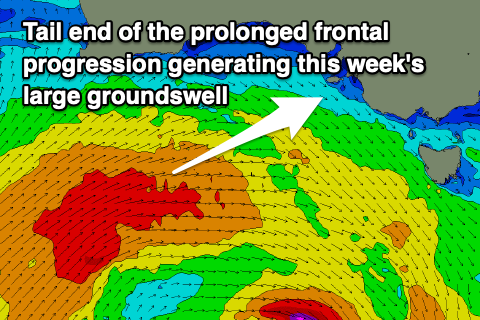 That being an intense polar low that formed in our far, far swell window late last week, west of the Heard Island region, pushing slowly east on the weekend while generating a fetch of weakening severe-gales. The progression has since projected up and under Western Australia while continuing to generate a broad fetch of W/SW gales and will weaken while tracking up and across us tomorrow.
This final stage of the progression will bring the mid-period energy, with Middleton due to be around 3ft Wednesday morning, though building to 4-5ft+ later in the day with the Mid Coast being around 2ft, building to 3ft into the afternoon.
Thursday should see solid 5-6ft sets across Middleton (easing into the afternoon) though a little inconsistent with 3ft+ surf across the Mid Coast and winds will shift S/SW, remaining strong across the South Coast. The Mid Coast will likely see early S/SE winds, swinging gusty S/SW mid-morning.
The remnants of the frontal progression will form into a broad, multi-centred low across Victoria into the end of the week and this will see persistent S/SW winds aimed into both our coasts on Friday as the swell eases, S/SE early on the Mid Coast again.
Saturday morning should see winds become lighter, tending SE on the Mid Coast and W/NW down South before shifting W/SW through the day along with tiny 1-1.5ft leftovers in the gulf, but 2-3ft surf down South.
Some new, mid-period S/SW swell is expected Sunday, generated by an unfavourably aligned frontal system tracking towards the polar shelf, generating NW gales. This should boost Middleton back to 3ft while the Mid Coast looks to become tiny. Light NE winds are expected, creating great conditions down South ahead of weak sea breezes.
Longer term a high will move in resulting in smaller, less consistent swells through next week but we'll have a closer look at this Wednesday.