Windy week with plenty of surf, improving slowly on the weekend

South Australian Surf Forecast by Craig Brokensha (issued Monday March 7th)
Best Days: Mid Coast Wednesday, Friday and Saturday mornings for keen surfers down South, Sunday, Monday and Tuesday mornings down South
Features of the Forecast (tl;dr)
- Moderate sized SW groundswell for Wed with fresh SE tending strong S/SE winds, easing a touch Thu with lighter morning E/SE winds and S/SE sea breezes
- Reinforcing mid-period SW swell Fri with E-E/NE winds and S/SE sea breezes, easing Sat with similar winds
- New SW groundswell Sun AM with E/NE-NE tending S/SE winds, easing Mon and Tue with NE tending S/SE winds
Recap
A fun pulse of swell for the Mid Coast on Saturday with workable winds and 1-2ft sets, cleaner yesterday but tiny and back to 1ft. The South Coast cleaned up Friday evening but the weekend was a mess with strong onshore winds and a junky mix of swells.
Today conditions are still a mess on the South Coast with tiny, bumpy surf on the Mid.
This week and weekend (Mar 8 - 13)
Looking at the week ahead and unfortunately we're still in an entrenched summer pattern with dominant high pressure, squeezed on its eastern flank by a strong low forming off the East Coast.
This will result in strong, persistent SE-S/SE winds during the coming week, improving slowly through the weekend as the low pushes off east towards New Zealand.
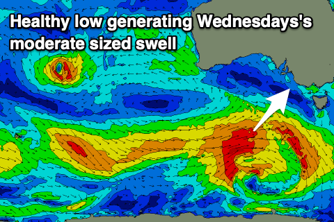 Tomorrow and Wednesday will see gusty SE tending stronger S/SE winds developing across the South Coast along with a new, moderate sized SW swell. This swell is being generated by a healthy polar low that's currently moving in under the country with a fetch of strong to near gale-force W/SW winds being produced the last couple of days.
Some decent size is due off this low, peaking to 4ft+ across Middleton on Wednesday morning but with those poor winds, while the Mid Coast should see 1-1.5ft sets.
The swell will ease into Thursday but weaker, trailing polar frontal activity should generate some reinforcing mid-period SW swell Friday, maintaining 3ft+ waves across Middleton but only to 1ft on the Mid Coast.
Winds will try and improve later in the week, shifting lighter E/SE on Thursday morning, but Friday should see slightly better E-E/NE winds through the morning, creating peaky, lumpy conditions.
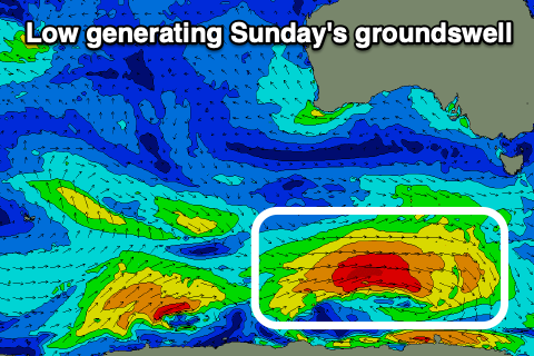 Saturday should ease back from 2-3t across Middleton and a light E-E/NE wind is again expected across the South Coast, with Sunday seeing a better E/NE-NE breeze. Swell wise, a new S/SW groundswell is due Sunday, generated by a strong polar low firing up south-west of Tasmania later this week. A tight fetch of gale to severe-gale W/SW winds are forecast, producing a fun kick in size to 3ft+ across Middleton (tiny on the Mid Coast).
This swell will ease into Monday and Tuesday but conditions will become cleaner with morning NE winds ahead of sea breezes.
Longer term, the outlook is slow for the rest of next week with no decent swells owing to the persistent progression of high pressure systems across our swell window. We may see some new swell later next weekend but check back through the week for more on this.
Comments
Hopefully we only have to put up with this relentless awful weather pattern for a couple of weeks longer!
Fingers crossed!