Good surf tomorrow, then windy with a new swell for Saturday

South Australian Surf Forecast by Craig Brokensha (issued Wednesday September 22nd)
Best Days: South Coast tomorrow and protected spots early Friday, Mid Coast for the keen Saturday, Sunday morning South Coast, Monday morning South Coast, Tuesday South Coast
Features of the Forecast (tl;dr)
- Moderate sized S/SW groundswell building tomorrow, peaking later with mod-fresh NW tending weaker W/NW winds
- Easing S/SW groundswell Fri with fresh to strong W/NW winds, shifting strong W/SW mid-morning and SW late
- Mod-large SW groundswell for Sat with strong S/SW winds, easing through the day and tending S. S/SE winds on the Mid, shifting S/SW at periods through the day
- Easing SW swell Sun with E/NE-NE tending SE winds, smaller Mon with fresh NE-N/NE tending E/NE winds
- Small, mid-period SW swell for Tue with N/NE tending NW winds
Recap
The South Coast was large, poor and onshore yesterday while the Mid Coast offered a window of cleaner conditions and 2-3ft sets through the morning, a but smaller and sloppy into the afternoon.
This morning the South Coast has cleaned up while hanging in there at 3-4ft, while the Mid Coast saw a light onshore breeze but tiny, lumpy/bumpy 1ft sets.
This week and weekend (Sep 23 - 26)
The end of the week is looking even better surf wise for the South Coast, with a good quality S/SW groundswell due along with great winds before a change moves through Friday.
The source of the swells, the first building tomorrow (peaking into the afternoon) is a vigorous polar frontal progression that's swung in from the south-east Indian Ocean.
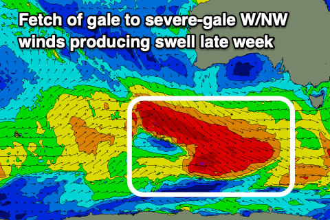 A initial fetch of gale-force NW winds was followed by severe-gale W/NW winds, moving east-southeast and then east through our south-western and southern swell windows. While not ideally aimed in our swell window, the stronger frontal system moving in on top of the active sea state generated ahead of it will produce a significant open ocean swell, with good amounts of energy spreading radially up and into us tomorrow.
The surf should be around 3ft in the morning across Middleton before pulsing to a good, strong 4-5ft through the late afternoon as the Mid continues at 0.5-1ft.
The swell is then due to ease back from 3-5ft on Friday morning, remaining tiny on the Mid Coast.
Winds will be moderate to fresh from the NW tomorrow morning, tending W/NW while abating a little into the afternoon (N/NE early on the Mid), while come Friday a fresh to strong W/NW breeze is due to give into a W/SW change by mid-morning so try protected spots early.
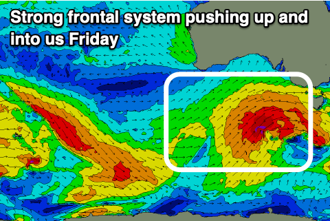 This change will be linked to a strengthening polar low pushing up and into Victoria, with some tiny windswell possible into the afternoon on the Mid Coast. The South Coast will likely see some building mid-period SW swell later in the day but with strong SW winds.
Into Saturday, the swell from the low proper is due to fill in, producing moderate to large surf across the South Coast owing to a great fetch of gale to severe-gale W/SW tending SW winds being projected through our swell window.
The swell looks bigger than forecast on Wednesday with Middleton now due to see 4-6ft surf, easing slowly through the day and down from 3-4ft on Sunday. The Mid Coast only looks to reach 1ft to occasionally 2ft.
Winds will unfortunately be strong from the S/SW on Saturday morning (easing through the day) as a high starts to move in behind Friday's change, with the Mid Coast seeing morning S/SE winds, shifting S/SW through the day and back to the S/SE late.
As the high pushes further east winds will swing back around to the E/NE-NE on Sunday morning, creating cleaner, though still lumpy conditions down South as the swell eases.
 Into early next week, much cleaner and better surf is due across the South Coast swell magnets with a fresher N/NE-NE breeze, tending E/NE into the afternoon but with easing 2-3ft waves across Middleton.
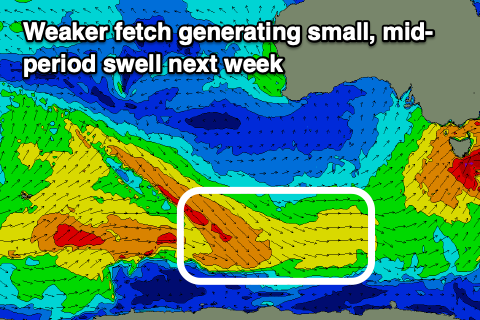
Tuesday looks smaller again (2ft Middleton), though steadying as a small, background SW swell fills in from weaker polar frontal activity south of Western Australia on the weekend. Winds look to be N/NE tending NW as a mid-latitude low starts pushing in from the west, NW to SW on Wednesday as the low pushes further east.
The Mid Coast should see a small W'ly swell Wednesday/Thursday from the northern flank of the low but only to 1ft to possibly 2ft or so at this stage. We'll have a closer look at this on Friday,
Comments
Looking good this morning..