Wintery period ahead with strong, windy swells

South Australian Surf Forecast by Craig Brokensha (issued Wednesday September 15th)
Best Days: Friday morning down South, Saturday protected spots down South, Sunday morning down South, protected spots Monday and Tuesday, South Coast Thursday and Friday
Features of the Forecast (tl;dr)
- Small, inconsistent surf to end off the week with fresh NE tending E/NE winds tomorrow, strong N/NE tending weaker N/NW Fri AM, W/NW-W into the PM and strengthening
- Inconsistent SW groundswell Sat with strong W/NW winds
- Large, building W/SW groundswell later Sat, easing Sun (biggest down South Sun AM) with strong NW tending W/NW winds Sun
- Large SW groundswell building Mon with strong W/NW tending W/SW winds, still large Tue AM but easing with strong W/SW-SW winds
- Easing surf Wed with weaker SW winds
- Fun Thu with N/NW winds
- New S/SW groundswell building late Thu, peaking Fri AM with fresh N/NW winds
Recap
Monday's fun waves eased back into yesterday on the Mid Coast with smaller, but cleaner 1-2ft sets left across the swell magnets, clean again today but tiny.
The South Coast was much more settled and a fun 2-3ft across Middleton with clean conditions, while today is another beautiful one with light offshore winds and 2ft sets continuing across Middleton.

Fun options down South
This week and next (Sep 16 - 24)
We've got small waves due to persist across the South Coast to end out the week, with a mix of inconsistent background swells due to keep infrequent 2ft sets hitting the Middleton stretch.
Winds tomorrow aren't ideal and will be blowy from the NE, shifting E/NE through the afternoon, favouring spots like Goolwa and other eastern ends of beaches.
A trough moving through Friday will see strong, dawn N/NE winds, quickly abating and tending N/NW through the morning and W/NW-W after lunch. Therefore the mid-late morning session looks best.
From the weekend we'll be looking at an overactive period of surf as a series of strong lows and cold fronts push in from the west and south-west.
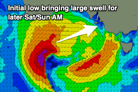 Firstly though, we've got a good, inconsistent SW groundswell due Saturday, generated by a strong, broad polar frontal progression firing up around the Heard Island region last Sunday/Monday.
It'll be inconsistent but we should see good 3ft waves across Middleton during the morning (1-1.5ft on the Mid Coast), but into the afternoon we're due to see a larger W/SW swell start to build across both coasts.
The source of this swell will be a strong low firing up under the Western Australian coast tomorrow evening, projecting a fetch of severe-gale W/SW winds through our western swell window, then passing under us Saturday afternoon and evening while slowly weakening. The low is now forecast to be broader and positioned further south, bringing more size for the South Coast.
This low will bring strong W/NW winds on Saturday, and some building W/SW groundswell into the afternoon, large late with the Mid Coast due to build to 3ft with the South Coast kicking to 3-5ft. We should see the groundswell easing from the 3ft range on the Mid Sunday morning, but the South Coast will see the peak in energy with strong 4-5ft+ surf, easing into the afternoon.
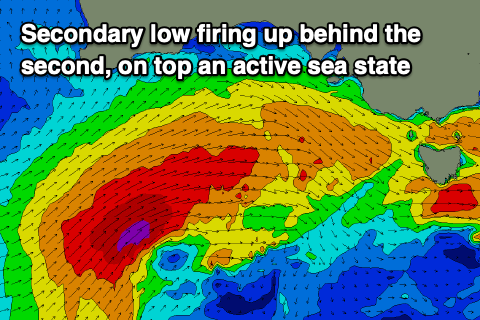 A secondary approaching low will tip winds around to the NW Sunday morning, though still strong and becoming stronger from the W/NW into the afternoon as the low nears closer. This will favour protected spots down South, and create, choppy, poor conditions on the Mid.
This secondary low will be positioned a touch further south again, and project a broader fetch of severe-gale to storm-force W/SW winds up through our south-western swell window (more favourably aimed into the South Coast) through Saturday, easing under us Sunday.
This will produce a larger SW groundswell for the South Coast, building Monday and likely peaking overnight, easing Tuesday.
Size wise, building surf from 3-5ft to 6-8ft+ is due across the South Coast into later Monday, easing from a similar size on Tuesday morning but with strong W/NW tending W/SW winds Monday, strong W/SW-SW on Tuesday. This won't be favourable for any locations besides novelty breaks, while the Mid Coast looks to build to a stormy 3ft Monday afternoon, easing from 2-3ft Tuesday.
 Weaker SW winds are likely into Wednesday as the swell continues to ease, possibly light S/SE early on the Mid, but Thursday looks a better day to surf with N/NW tending variable winds down South and 3ft of leftover swell across Middleton.
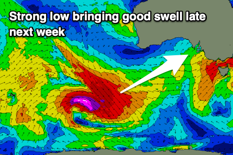
Now, later in the day Thursday but more so Friday, a strong new S/SW groundswell is on the cards along with fresh N/NW winds, generated by a strong polar low firing up south-west of Western Australia early next week, but more on this in Friday's update.