Windy weekend with building, stormy surf Sunday, cleaner as it eases next week

South Australian Surf Forecast by Craig Brokensha (issued Friday September 10th)
Best Days: Today down South, protected spots South Coast tomorrow morning, Mid Coast Monday, South Coast Tuesday
Features of the Forecast (tl;dr)
- Easing mix of mid-period S/SW swell and W/SW groundswell tomorrow with fresh W/NW winds, strengthening through the day (light NW on the Mid early)
- Stormy mix of swells building Sun with strong W tending SW winds into the PM
- Large SW groundswell easing Mon with strong S winds (S/SE on the Mid and weaker)
- Easing SW groundswell Tue with N/NE tending SE winds down South, E/NE tending SW on the Mid
- Slow end to the week with NE winds
- New mix of W/SW swells late Fri and next weekend
Recap
Great conditions across the South Coast yesterday morning with a drop in size from Wednesday's strong sets, easing from 2-3ft across Middleton. The Mid Coast was tiny and wind affected, choppy into the afternoon.
Today the swell has lifted a bit for the morning surf with clean, glassy 2-3ft waves off Middleton again, with 1-1.5ft sets on the Mid Coast though more of a tease than anything. The afternoon incoming tide should give it a push to 2ft but winds will remain gusty from the N'th. The South Coast should also see more size to 3-4ft across Middleton with a building mid-period S/SW swell as winds remain favourable from the N/NW.

Nice sets this afternoon
This weekend and next week (Sep 11 - 17)
This afternoon's pulse of mid-period S/SW swell will ease through tomorrow, while the Mid Coast will also see the W/SW energy easing with less favourable winds and conditions. The Mid looks to ease back from 1-1.5ft with a light NW breeze, giving into a strong, late afternoon W/SW change.
 The South Coast looks to ease back from 3ft on the sets across Middleton with fresh W/NW winds, strengthening into the afternoon, so stick to protected spots.
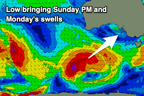
The strengthening W'ly winds will be linked to a polar low that's currently south-southwest of Western Australia, projecting north-east and up towards us today, through the Bight tomorrow and then across us Sunday.
Today, a great fetch of severe-gale SW winds are being generated, with this fetch weakening slightly as the low pushes up towards us. On approach Sunday a small intensification will see strong S/SW winds projected up into the southern Eyre Peninsula and gulfs, a little further west than ideal regarding generating a sizey stormy swell for the South Coast.
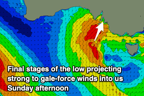 This will keep winds blowing more favourably from the W for a longer period Sunday morning, shifting strong SW into the afternoon and this is when we'll likely see the swell starting to really build.
The South Coast looks to be only a weak 2ft or so off Middleton Sunday morning and average with that strong W'ly wind, kicking through the day and reaching 4-6ft later in the day, though peaking Monday to 5-6ft across Middleton as the groundswell from the initial stages of the low peaks. The Mid Coast will see stormy, choppy waves building Sunday to 3ft through the morning, easing from 2ft on Monday with a lighter, morning S/SE breeze, shifting S/SW through the day and back to the S/SE late.
The South Coast will be poor Monday with strong S'ly winds, easing through the day.
We should see winds improve fairly rapidly into Tuesday as a strong high moves in from the west, bringing a light N/NE breeze to the South Coast, E/NE on the Mid, with weak afternoon sea breezes across both regions.
Size wise, Monday's SW groundswell will be on the ease, dropping from 3ft or so across Middleton, tiny on the Mid. The rest of the week looks clean in the mornings, but swell wise, the high will prevent any significant swell producing systems developing.
Also a strong, slow moving mid-latitude low forming off the Western Australian coast will initially sit too far north to generate any swell, slipping south and into the Mid Coast's swell window Thursday evening. This should produce a good W/SW groundswell for late Friday/next weekend, mixed in with a longer-range groundswell from the Heard Island region.
No major size is due off these swells for the South Coast but the Mid looks to see 2-3ft surf with west to north-west winds. More on this Monday though. Have a great weekend!
Comments
Pity about the wind on the Mid..
Looks fun down South..