Strong westerly swell with favourable winds for the Mid

South Australian Surf Forecast by Craig Brokensha (issued Monday August 23rd)
Best Days: This afternoon on the Mid Coast, Mid Coast tomorrow and Wednesday morning, South Coast Thursday morning but more so Friday morning, South Coast Monday morning
Features of the Forecast (tl;dr)
- Mod-large W/SW groundswell tomorrow with gusty S/SW-S winds down South (mod S/SE-SE in the AM on the Mid, shifting SW and then S/SE late)
- Easing W/SW groundswell Wed with morning SE winds on the Mid, mod S down South
- New S/SW groundswell for Thu with E/NE tending SE winds down South, better Fri and easing with fresh N/NE tending E/NE winds
- Tiny Sat
- Inconsistent W/SW groundswell building Sun PM with strong N/NE tending NW and then W/NW winds
- Easing W/SW groundswell Mon with gusty N/NW winds
- Large swell for mid-next week
Recap
A low point in swell and slow start to the weekend, but clean down South and best across the swell magnets, while some new, inconsistent W/SW groundswell filled in through the afternoon and held yesterday to 2-3ft across Middleton.
The Mid Coast started tiny but kicked a bit more to 1-2ft yesterday though with choppy conditions. The Yorkes Classic was run and won, with Digby Tooze taking out the Mens and Sky Faddy the Womens in great 3-5ft surf.
Today we've got a continuation of moderate sized W/SW swell, 2ft or so on the Mid Coast and workable, 2-3ft down South but with an onshore change moving through. This is a little under expectations but we should see our stronger W/SW groundswell pushing in on dark today, but tomorrow will be a better chance to surf.

Fun waves on the Mid this AM
This week and weekend (Aug 24 - 29)
The swell seen over the past couple of days has consisted of mostly mid-period W/SW energy, with larger, and stronger surf on the way for tomorrow.
The source of tomorrow's W/SW groundswell was a strong polar low firing up from the Heard Island region, towards and then under Western Australia, weakening over the weekend while pushing towards us.
The remnants of this storm has brought today's change (in the form of a trough rather than front) and we'll see the groundswell arriving late today but peaking tomorrow morning (the swell has just hit the CDC buoy).
The Mid Coast should see good 3ft sets on the favourable parts of the tide for most of the day, with 4-5ft waves across Middleton. Winds will be poor and gusty from the S across the South Coast tomorrow as the trough forms into a low off the southern NSW coast, but this will favour the Mid with lighter, morning S/SE-SE winds, shifting SW into the afternoon and back to the S/SE late.
 The swell will ease into Wednesday as moderate S'ly winds persist down South with 3ft+ sets across Middleton, SE on the Mid in the morning but back to a smaller 2ft on the sets.
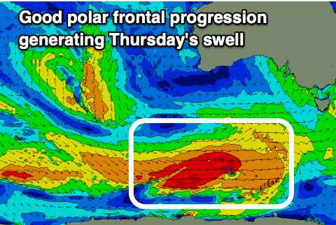
Into Thursday, we've got a good, moderate sized S/SW groundswell on the way, generated by a healthy polar frontal progression firing up under the country over the coming days.
Good fetches of W-W/SW gales will be generated through our south-western and then southern swell window, producing a moderate sized S/SW groundswell that should kick on dark Wednesday but peak Thursday with strong 3-5ft sets across Middleton. The Mid Coast won't see much in the way of swell owing to the direction with 0.5-1ft sets due.
Winds will start to improve down South, likely tending E/NE for a period during the morning but it won't be great. Afternoon SE sea breezes are also due.
 Friday looks the pick with 3ft of easing S/SW groundswell and offshore N/NE winds, shifting E/NE into the afternoon.
The surf will fade and bottom out into the weekend owing to a broad, slow moving high pushing in from the west through the middle to end of this week (linked to the improving winds). This will block any major swells firing up and we'll have to rely on longer range energy.
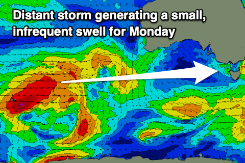
One such W/SW groundswell is due Sunday afternoon and Monday morning, generated by a distant polar low firing up around the Heard Island region tomorrow, projecting a fetch of W/SW gales through our distant western swell window.
 It'll be inconsistent but sets to 1-2ft are due on the Mid into Sunday afternoon, easing from a similar size Monday morning, with Middleton coming in at 2ft+.
Winds will swing from a strong N/NE to NW and then W/NW breeze on Sunday as a weak frontal system moves through, with winds swinging back to the N/NW on Monday but remaining fresh, favouring the South Coast.
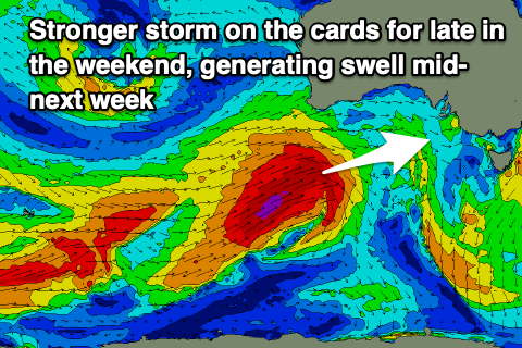
Longer term, a much more significant frontal progression is forecast up through our western swell window on the weekend and early next week, likely bringing another large, windy W/SW groundswell episode. More on this in the coming updates.