Great run of surf for the South Coast

South Australian Surf Forecast by Craig Brokensha (issued Monday August 16th)
Best Days: Every day on the South Coast through this Period, the Mid Coast for the keen tomorrow morning
Features of the Forecast (tl;dr)
- Sizey, slowly easing S/SW groundswell tomorrow, easing much more noticeably Wednesday while dropping in period and strength
- Light morning W/NW winds down South with S/SW sea breezes, NE tending NW on the Mid
- N/NW tending variable winds down South
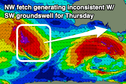
- Inconsistent W/SW groundswell for Thu with moderate N/NE winds, shifting N/NW-N into the PM
- Easing W/SW groundswell Fri with strengthening N/NW-NW winds
- Inconsistent W/SW swell building Sat, holding Sun with a mid-period W/SW swell in the mix
- Gusty W/NW winds Sat AM, easing into the PM, with strong N/NW winds Sun
- Large W/SW groundswell likely early next week
Recap
Great surf down South Saturday with a strong, new SW groundswell and offshore winds, clean and a fun 2ft on the Mid.
The swell dropped into yesterday but the South Coast was still great with better options across more exposed breaks, smaller on the Mid and more wind affected.
Today we've got a strong, large new SW groundswell with favourable winds for protected spots down South, bumpy and a small 1-2ft on the Mid owing to the swell direction.
This week and weekend (Aug 17 - 22)
Today's large mix of SW groundswell and mid-period energy will peak this afternoon, with the swell swinging more S/SW in direction through tomorrow while easing.
The low linked to the swell was still generating S/SW gales in our southern swell window this morning, and this should keep wave heights up into tomorrow afternoon ahead of a more noticeable drop in size on Wednesday. The Mid Coast may see slow 1-2ft sets, but expect waves mostly to 1-1.5ft while the South Coast should still see 4-5ft waves across Middleton, easing slightly later and then from 3ft on Wednesday.
 Winds will improve and be lighter from the W/NW tomorrow morning though there might be a bit of lump still in the surf down South, with light NE winds on the Mid. Weak afternoon sea breezes are due across both coasts, NW on the Mid and S/SW down South.
Come Wednesday, light N/NW winds are due down South, opening up all options, with variable breezes due into the afternoon.
On Thursday moderate N/NE winds will favour exposed breaks, shifting N/NW-N into the afternoon along with a new, inconsistent W/SW groundswell.
The source of this swell is quite unique, that being a fetch of gale to severe-gale NW winds ahead of a strong mid-latitude low, drifting south-east through the southern Indian Ocean.
 This system is now breaking down on the polar shelf, south-southwest of Western Australia, with an inconsistent, tricky swell due to fill in Thursday. We'll see swell spreading radially our from this fetch, likely offering inconsistent 2ft sets across Middleton, with 3ft sets at Goolwa, tiny and to 1ft on the Mid Coast.
This is under model forecasts which are over-forecasting the size, mixing mid-period leftover swell from Wednesday with the new long-period signal.
Fading surf from 2ft is due on Friday across the Middleton stretch, tiny on the Mid with strengthening N/NW-NW winds.
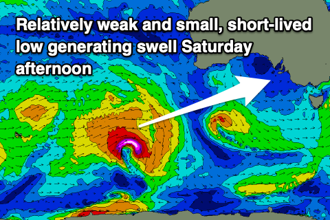
Moving into the weekend and there are a couple of smaller, mid-period W/SW swells on the cards for Saturday afternoon and more so Sunday.
Firstly a relatively short-lived low firing up south-west of Western Australia should produce an increase Saturday afternoon, increasing to 2-3ft across Middleton, 1-1.5ft on the favourable parts of the tide across the Mid Coast.
 A secondary weaker front passing under the country late week should generate a similar sized pulse for Sunday. Winds will be a bit of an issue though and gusty from the W/NW, possibly easing late in the day. Sunday looks much better with strong N/NW winds ahead of a vigorous low pushing in from the west.
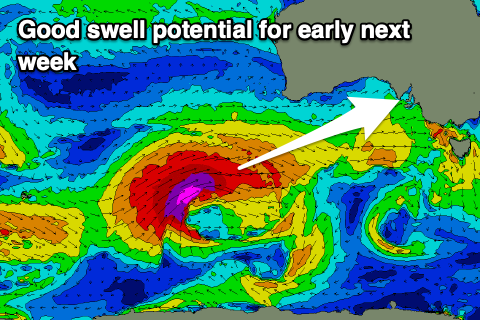
This low is due to form just east of the Heard Island region on Thursday, projecting an excellent fetch of severe-gale to storm-force W/SW winds up and under WA, towards us Sunday while weakening.
This will produce a large, long-period W/SW groundswell for Monday afternoon and Tuesday morning along with what at this early stage looks to be W/SW winds Monday and S/SW winds Tuesday. More on this in Monday's update.