Large, stormy surf on the way, improving as it eases

South Australian Surf Forecast by Craig Brokensha (issued Friday July 16th)
Best Days: South Coast tomorrow AM and stormy spots on the Mid, both coasts Sunday, South Coast Monday
Features of the Forecast (tl;dr)
- Large, stormy waves on both coasts tomorrow with strong W/SW winds (likely W/NW around Victor in the AM), easing late
- Easing W/SW swell Sun with W/NW winds (variable on the Mid in the AM)
- Inconsistent SW groundswell for Sun PM and Mon AM with strengthening N/NW tending NW winds Mon
- Strong S/SW change with a new S/SW swell Tue, easing Wed with W/sW winds
Recap
Choppy, small 1-2ft waves out of the NW on the Mid Coast yesterday with strengthening NW winds, larger today with a mix of W and NW swells to 2-3ft. We'll continues to see the surf building in size as stormy conditions continue to develop under strengthening W/NW tending W winds.
The South Coast offered a touch more size than expected with 1-2ft sets though bumpy conditions with NW winds yesterday and W/NW winds today. We did see yesterday afternoon clean up for a period though as winds tended N/NW.
This weekend and next week (Jul 17 - 23)
The strengthening winds on the coast today are linked to a vigorous, strengthening cold front pushing in from the west, bringing a cold, windy change this evening.

Vigorous cold front pushing through the Bight (note the speckled cold air)
We'll see a large, stormy swell developing on the Mid Coast late today, likely peaking overnight and still solid tomorrow morning but easing as strong, morning W/SW winds slowly abate. Size wise easing 3-5ft surf is due, while the South Coast should see solid 6ft surf across Middleton but with those strong, poor W/SW winds. Hi-res modelling has winds out of the W/NW through the morning so try protected spots for a raw wave.
Winds are due to ease right back into Sunday morning as we fall in between fronts and the Mid now looks likely to see a period of variable breezes, only light to moderate onshore into the afternoon. The South Coast should see a W/NW breeze, shifting NW later in the day.
Size wise, the Mid Coast looks to ease back from 2ft to possibly 3ft with surf in the 4ft range across Middleton. With the favourable winds both coasts should offer fun waves all day.
Now, our inconsistent SW groundswell for the afternoon is still on track, generated by a strong polar low firing up east of the Heard Island region the last couple of days. It'll be inconsistent but stronger with sets due to hold 3-4ft across Middleton into the afternoon when it fills in Sunday, easing from a similar size Monday morning. The Mid will be back to a slower 1ft to maybe 2ft on Monday.
Winds will favour the South Coast Monday as a vigorous cold front approaches from the west, fresh and N/NW early but strengthening while tending NW.
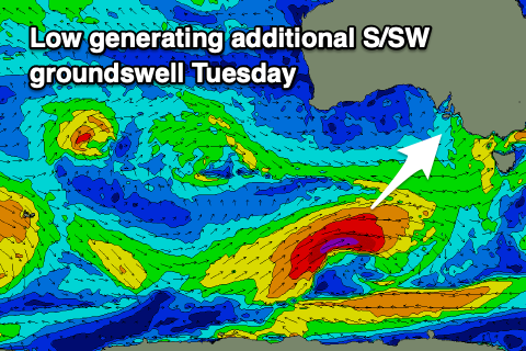 Come Tuesday conditions will be poor across all locations as a strong S/SW change moves through in the wake of the front.
This will spoil a good, new reinforcing S/SW groundswell, generated by a great pre-frontal fetch of strong to gale-force W/NW winds moving in from the south-east Indian Ocean, followed up by slimmer W/SW gales as the front forms into a polar low, south of the country.
So an increase in size is due from both the front and the groundswell with Middleton holding the 4ft range, though a mess, easing Wednesday from the same size as winds shift back to the W/SW. Thursday looks better wind winds around to the N'th though strengthening again ahead of high-riding mid-latitude low. More on this Monday though. Have a great weekend!